
As Washington, DC developed its climate adaptation plan, Climate Ready DC, the city commissioned downscaled climate change projections for the city. The projections show a significant increase in the number of dangerously hot days and longer and more frequent heatwaves in the coming decades – underscoring the need to address heat and potential impacts to public health. In order to inform the implementation of Climate Ready DC, the Department of Energy & Environment sought to better understand which areas of the city are home to the most heat-sensitive populations; have the highest outdoor heat exposure; and are most vulnerable to adverse heat-health outcomes.
The team developed maps of vulnerability to extreme heat in Census Block Groups in Washington, DC. In a Geographic Information System, we combined socio-demographic census data with variables describing the built environment and assembled, separately, indices of sensitivity and exposure to extreme heat and combined them into a cumulative Heat Vulnerability Index.
They obtained publicly-available data from the U.S. Census Bureau, as well as weather monitoring network observations and remotely-sensed data describing land cover in the built environment. Theydownloaded the data and assembled them in a commercial GIS software package using a license provided by one of the team member’s institution. In addition, the open source statistical analysis software R was used to conduct analysis and assemble data into an index. The team had hoped to use 911 call and patient data from the District’s 911 dispatch system. However, due to the limited time range of the data and concerns about its quality, it was not used in the final analysis.
The team met regularly, roughly every 2-4 week. The project lasted longer than anticipated due to challenges obtaining data.
The primary output of this project include:
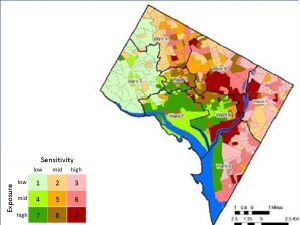
Map showing the results of the Heat Vulnerability Index by Census Track. Photo courtesy of Juan Declet-Barreto and Olga Wilhelmi
The Department of Energy Environment (DOEE), which is leading the implementation of Climate Ready DC, will use the results of this analysis to help target is strategies and programs related to urban heat island mitigation. They will also share the results and recommendations with their partner agencies working on emergency preparedness and the city’s broader resilience efforts. The results will also be shared with community members, especially in those areas identified as being most vulnerable. Specifically, DOEE will use the analysis in its engagement work in Ward 7, which is a priority planning area for the implementation of Climate Ready DC.
The recommendations and maps can be used to inform the targeting of programs to address urban heat islands and better prepare for extreme heat.
The team attributes its successful completion of this project to:
Should they have the opportunity to do this project again, they would:
For those anticipating starting their own community science project, the team advocates clearly defining/refining your research question as early as possible. A refined research question is key so that you can involve the necessary stakeholders, data sources, and partners as early as possible.
As the capital of the United States, the District of Columbia grapples with human-induced and natural threats ranging from counter-terrorism to hurricanes. The U.S. Global Change Research Program reports that average temperatures are already increasing in the District, along with the frequency of extreme heat, storms, and heavy rain events. Thanks to the urban heat island effect, the District experiences summertime temperatures that are nearly 5° higher on average than surrounding areas. Through collaborations with scientists, the District studied the potential health benefits of reducing the urban heat island and found that strategies like installing cool roofs and pavements, green roofs and shade trees could substantially reduce heat-related mortality. As the first step in developing a citywide climate adaptation plan, the District recently developed downscaled climate change projections for the city. The projections show a significant increase in the number of dangerously hot days and longer and more frequent heatwaves in the coming decades – underscoring the need to address heat and potential impacts to public health.
The District has a robust heat emergency plan that is activated whenever actual temperatures of the heat index reaches 95°F. However, while this solution helps respond to extreme heat events, it does not address how the District could leverage its built environment to help mitigate extreme heat risks over the long-term. Therefore, DC’s Climate Programs Analyst for the District’s Department of the Environment, Kate Johnson, would like additional ideas for what the District can do to substantially address extreme heat the city will continue to face over time. These ideas will help the District move towards sustainable solutions to combat heat extremes, and to incorporate those solutions into their climate adaptation planning
The DC team met on March 13th to discuss the preliminary results. The data that they received from the DC Fire and Emergency Management Services (FEMS) Department reveals that there is a high incidence if 911 calls in Wards 2, 5, 7 & 8. Many downtown calls had no home address, presumably indicating that they were either tourists or homeless residents. Since only one year of data is provided, this analysis is exploratory. For any conclusions to be made about the threshold for heat emergencies, the team says they will need data going back several years. So far, policy implications include:
• Identifying areas for investments such as tree planting for residential units and developments
• Identifying the most at risk populations, based on location; and,
• Sensitivity for targeted outreach
In their next steps, the team will await as to whether they can obtain data going back to the Summer of 2010. The team also hopes to obtain stroke data to include in their analysis. Juan Declet-Barreto will be providing a map with street level data to identify any shelters that may be near 911 call hot spots. Alexis Goggans will ascertain whether a presentation at the Vulnerable Populations Healthcare Coalition meeting in April is possible. Regardless of whether they get further data, Juan already has census block group level vulnerability analysis ready for sharing in any upcoming public meetings.

Alexis Goggans currently serves as a Program Analyst in the Department of Energy and the Environment’s (DOEE) Urban Sustainability Administration. As a program analyst, Ms. Goggans coordinates public, private and non-profit stakeholders to advance green building and climate change programs and policies in the District.
Prior to DOEE, Alexis was a Neighborhood Planner with the DC Office of Planning (OP), where she served as the East of River Planner/Ward 4 Planner and managed the Sustainable Congress Heights EcoDistrict Initiative. Before working at OP, Alexis was the Civic Engagement Manager for Justice & Sustainability Associates where she worked on the 11th Street Bridge Replacement Project and the H-Benning Streetcar Line. She also worked as the National River Cleanup manager with American Rivers.

Dr. Olga “Olya” Wilhelmi is a geographer with the National Center for Atmospheric Research whose research interests focus on interactions among weather, climate and society across scales, with the main emphasis on understanding societal risk, vulnerability and adaptive capacity to extreme weather events and climate change. She is a project scientist in the Research Application Laboratory and is the head of NCAR’s Geographic Information Science Program.

Dr. Juan Declet-Barreto is a Fellow in the Climate and Clean Air program at the Natural Resources Defense Council in Washington, DC. Juan has a Masters in Geography and a PhD in Environmental Social Sciences from Arizona State University. He has extensive expertise in the social, ecological, and human health dimensions of climate change impacts, and has developed a research program centered on an interdisciplinary approach to researching human vulnerability to climate change.