
In 2021, Thriving Earth Exchange’s Natasha Udu-gama took the Hano Wene Indonesian Foundation through our approach to community science. Hano Wene works in Indonesia to address education through a holistic approach that includes not only formal education but also bringing electricity to communities, clean water, and food security. Recently, they teamed up with former Thriving Earth Exchange Community Science Fellow and now a Research Fellow at the Earth Observatory of Singapore, Nanyang Technological University Singapore, Neel Kasmalkar for a community science project in Tangma, Papua, Indonesia. Together, they worked on a community mapping project to better understand risks of floods, landslides, and other aspects of the local river.
They shared an update about this project, which you can read below. It is an exciting example of how former fellows continue to be engaged ambassadors for community science and how community science can make an impact around the world.
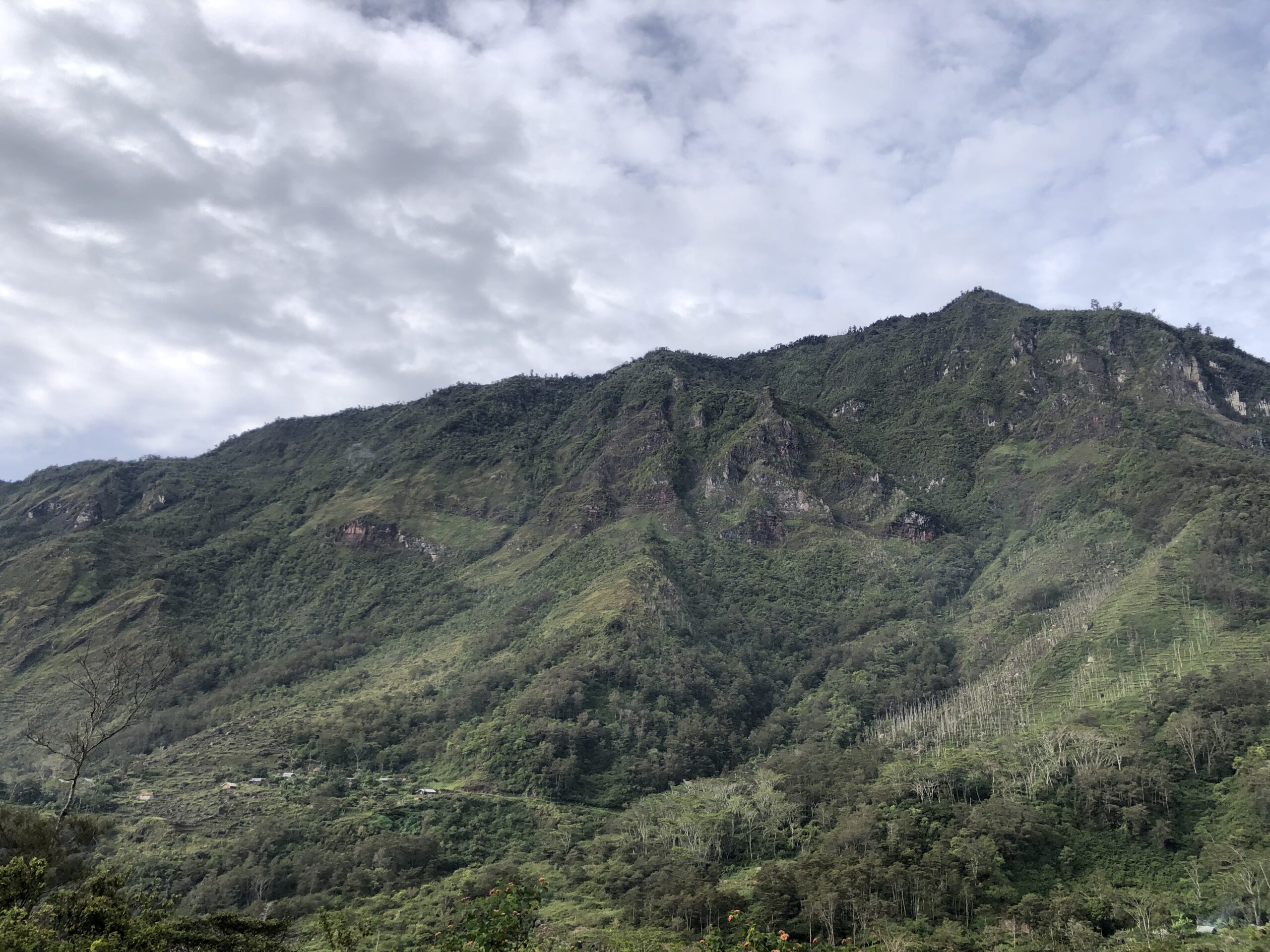
Photo of the site in Papua. Courtesy of the Hano Wene Foundation
The Hano Wene Indonesia Foundation in collaboration with the Earth Observatory of Singapore conducted Community Science Project research activities on the Anemage river, in Huewi village Papua. To get accurate and reliable results, this Community Science project activity involves many local stakeholders, such as local communities, village heads, women leaders, religious leaders, youth, and students from Huewi village. Each stakeholder had an opportunity to tell about their experiences with the Anemage River. This community science project aims to find out the current flow of Anemage water, floods, landslides, and other properties of the Anemage river.
Huewi village is located under Esilek and Wurupoma mountains. People in Huewi village live from . There are 300-500 people living in this place. There were more than 1000 people, but many of them moved to other villages to find a job and better life. To reach this village, it takes 8 hours driving from Wamena to Huewi approximately.
Anemage River is located in Huewi village, Tangma sub-district, Yahukimo Regency, Papua Mountain Province. This river flows from Mount Esilek to the downstream. Its water is clear and clean and thus used for drinking, bathing, cooking, bathing livestock and many other things by people in Huewi. Its name is taken from the local language which means blood purifier. In 1957, there was a landslide that destroyed people’s homes accompanied by flooding from the mountain. As a result of this, 23 people died. Only 5 residents survived the disaster, according to the oldest person in the Huewi village.
Community conversations. Courtesy of the Hano Wene Foundation.
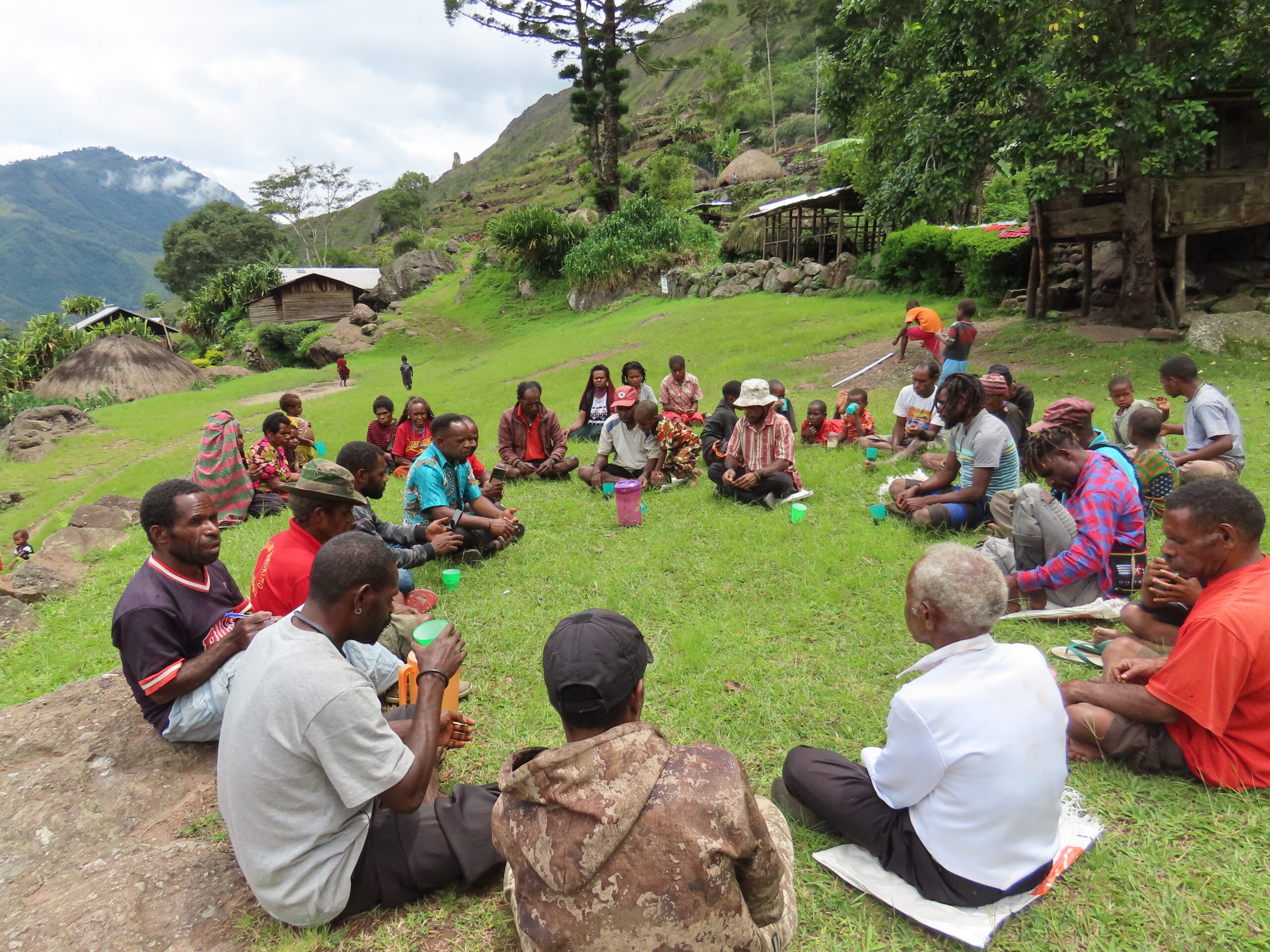
In the Community Science project, we sat with the local people in an open field and had a discussion about the Anemage river. There were about 20-25 people involved in this activity coming from Huewi village and neighboring villages. We also followed the customary rules of the village for the whole process, because it is difficult to tell the past trauma of floods and landslides to the new people. Before we started the map activity, we distributed sticky notes and pens to some representatives. They put some marks on well-known places, such as airports, churches, villages, bridges, mountains and rivers. After they wrote the name of the place, each person put the sticky notes on the map that was already available in front.
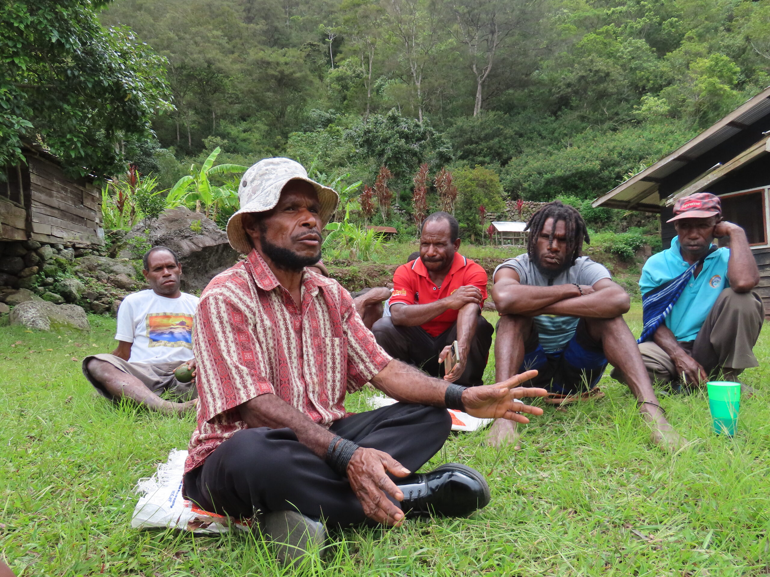
A community member shares their experiences with the community science team. Courtesy of the Hano Wene Foundation.
The interaction between people during the activity was extremely good. People were happy with the activities since it became an event in which they can discuss the issues faced by the village’s inhabitants, especially issues on the Anemage river. So far, there has been no activity like this in the village and they feel excited to have such positive and insightful activities in their village.
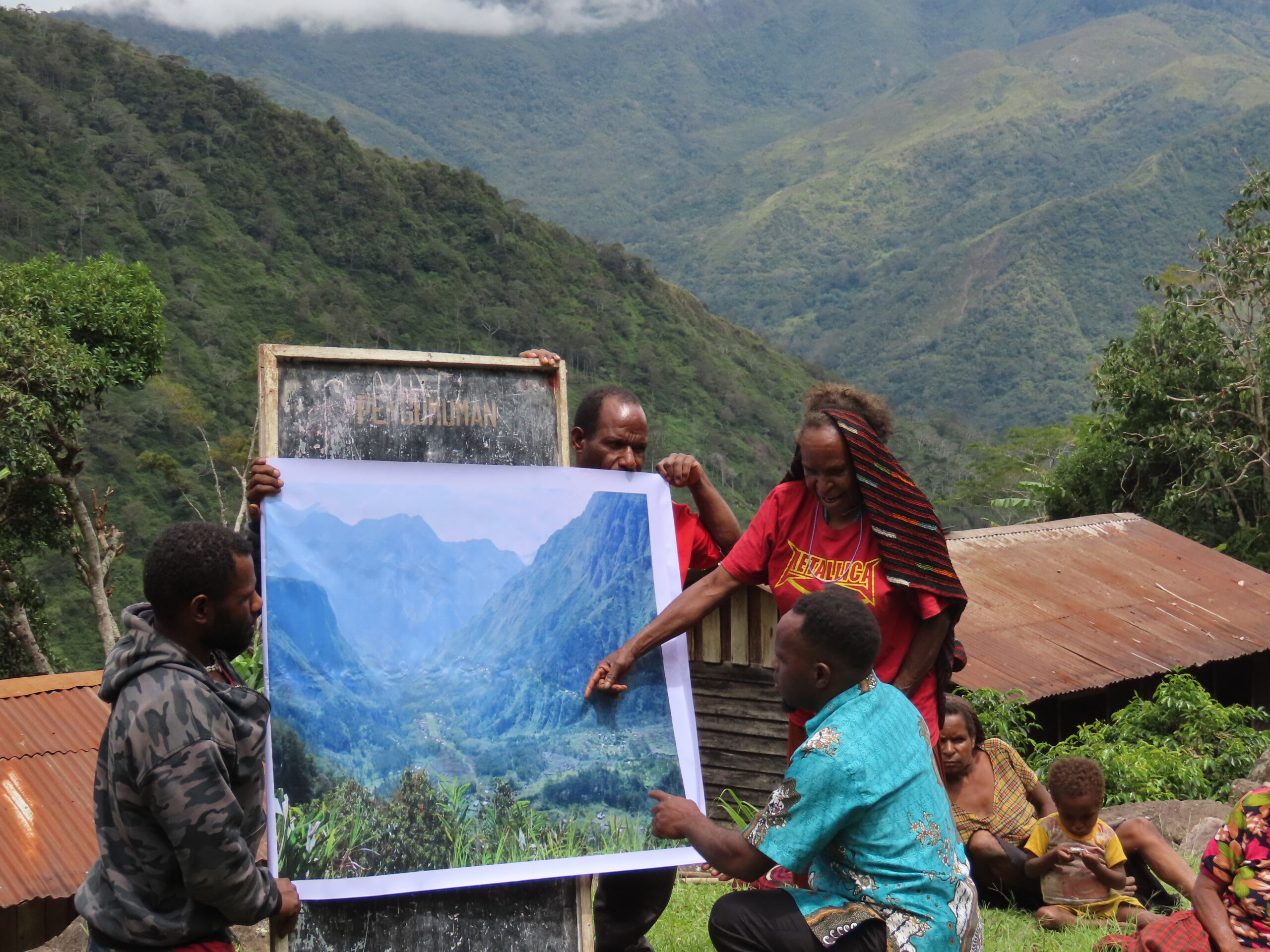
Community members comment upon the map. Courtesy of the Hano Wene Foundation.
List of questions and answers during the activity (translated and summarized from the original dialogue)
Question 1: Can you see anything on this map?
Answer 1: On the map we see a house in the village, a small airport, a church, a mountain and a village. There is Anemage river flowing near Huewi village, but it was covered by the mountain in the map, so we cannot see it. There is also the Aware, Pese and Kulugi rivers but they are all covered with green trees and mountains.
Question 2: Can you remember the location of the Anemage river that usually overflows at different times of the year?
Answer 2: Every year, the weather changes frequently from November to February and June to September. During the rainy season in November to February, the flow of water usually increases four times. Floods and landslides actually rarely happen in the Anemage river, even when it rains heavily only the water flow increases. Floods can occur when there are landslides from Mount Esilek. Landslides in Mount Esilek happens every 2-3 years. If the landslide is at a large scale, it can impact Anemage River, bringing large rocks, sand, and wood to the downstream affecting the destroyed residential area. But if the landslide is small scale, it does cause any damage to the river and residential areas downstream.
Question 3: Can you remember a time when the Anemage river overflowed unusually?
Answer: The Anemage River had been overflowed twice, accompanied by floods and landslides. The first was in 1957, when the Anemage and Aware rivers were still a single river. A landslide came from Mount Esilek to the residential area in a blink, resulting in 23 victims. This incident is one of the unforgettable phenomena since many of our relatives are victims. The second was in 2007 and accompanied by landslides, damaging crops around the river. Fortunately, there were no casualties.
The place that often overflows during the rainy season is around the pedestrian bridge, the only one bridge here. When it rains, the Anemage River overflows 4 – 6 meters from its normal level. The Anemage River also overflows near the Wulumo village. In this village, the Anemage River flows swiftly accompanied by landslides and can overflow up to 10 – 15 meters from its normal level. Those two places are close to the farms and thus the overflows damage crops.
During landslides and floods, the river can make other paths to flow, and will carry a lot of rocks, wood and soil from the top of the mountain to near the village. When these happen, they always damage crops.
Question 4: Can you remember in a year, around Huewi village where landslides often occur?
Answer 4: Above Huewi village, there is a mountainous area that crosses from the south to the west. The mountain is long and has several names, including Paliai, Wurupuno and Esilek. Landslides in these mountains do not occur every year, they only occur during the rainy season and during earthquakes. After the landslide, the Aware River used to flow in another direction, but now flows in the same direction as the Anemage River.
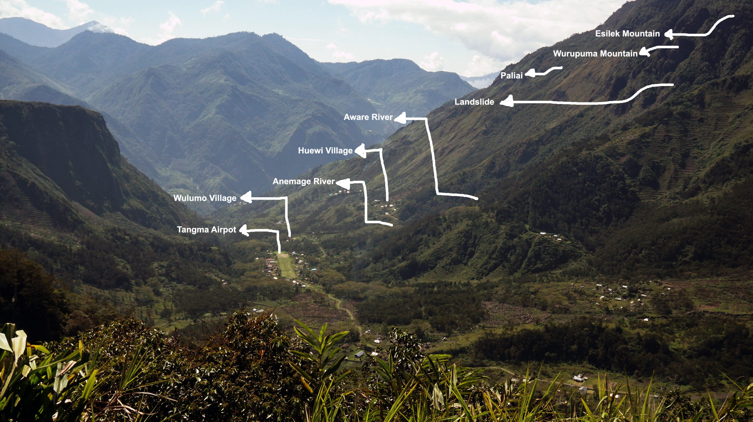
Community map developed through this project. Courtesy of the Hano Wene Foundation.
Details on the map (translated and summarized from the original dialogue):
- The small airport that was opened by the Missionary in Tangma village. Before the road was not yet developed in Tangma district, we always used a small plane to to the nearby city. But now there is a road, so we now go to town by car. We use the small airport when there is an important event, such as the district government coming to the village.
- Wulomo Village is one of the villages that is affected when the Anemage River overflows with landslides. Wulumo village is located in the downstream part of the Anemage river. When the Anemage river overflows, it can be up to 10-15 meters higher than usual because the area in Wulomo village is a flat and plain area.
- The Anemage river flows from under Mount Esilek through Huewi village, Esenapunu village and Wulukmo village. At the end of the river, it joins with the Kulugi River. In this map, it is not visible because the river is hidden by hills and green trees.
- Huewi village is located under Esilek mountain, close to Wulomo, Hipela and Songai villages. Huewi village is inhabited by four major tribes: Wolom, Elopore, Heluka and Heselo. People in Huewi village are farmers.
- The Aware River flows from the top of Mount Esilek. The Aware River is small, not as big as the Anemage. During the summer it does not flow. But during the rainy season, it flows abundantly and often causes landslides.
- In the past, landslides have occurred from Mount Esilek and Mount Wurupoma. The landslides were accompanied by floods, causing casualties and damaging crops.
- Paliai is one of the inactive mountains with landslides. People often open land to grow some plants. There are some residents who also have livestock there. There used to be some residents living there. However, since there is extremely limited access to reach Huewi village that is far away, they moved to Huewi village.
- Mount Wurupoma is above Huewi village. It is one of the active mountains causing frequent landslides, damaging the Anemage spring, and causing floods in the Anemage river.
- Mount Esilek is adjacent to Mount Wurupoma. Both are above Huewi village. Mount Esilek is slightly higher than Mount Wurupoma. The Aware river flows from Mount Esilek. When it rains heavily, its floods often damage people’s farms.
Conclusions
People in Huewi village love Anemage river since it is a source to fulfil their daily needs, such as drinking, washing and bathing. However, there are some bad memories of that because frequent landslides from Mount Esilek and Wurupoma causes an overflow on the Anemage River, making the water dirty and thus cannot be used for fulfilling their needs.
Authors: Neas Wanimbo and Dr. Handriyanti Diah Puspitarini, co-founders of Hano Wene Indonesia