
Assessing Flood Risk of Food Distribution Centers
Boston, Massachusetts, United States
Results
Final Project Summary: Assessing Flood Risk of Food Distribution Centers
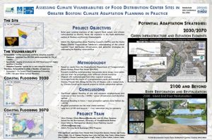
The primary objectives of this project were to build upon existing analyses of the region’s food system and climate vulnerabilities to identify flood risk exposure to the food distribution centers in Chelsea and Everett, Massachusetts in the greater Boston area. Chris Watson and Ellen Douglas were chosen by the Metropolitan Area Planning Commission (MAPC) lead, Axum Teferra, to collaborate with them to inform MAPC and the Metro Boston Climate Preparedness Taskforce of addressing the flood vulnerabilities of this critical regional food distribution infrastructure.
The MAPC-TEX project on “Assessing Flood Risk of Food Distribution Centers” completed in December 2016. To accomplish the project’s objectives, Watson, Research Fellow at UMass Boston, based the project’s results on the Massachusetts Department of Transportation’s Boston Harbor Flood Risk Model (BH-FRM). The BH-FRM used dynamic modeling techniques that incorporated storm surge, wave action and sea level rise projections under different climate scenarios. By using BH-FRM results, this project’s methodologies were aligned wtihother regional analyses. Further, he leveraged the results of a complementary study by Stantec/Woods Hole Group for the City of Chelsea and a design study by Climate Creatives to expand the project to include various adaptation options.
The final project outcome is a poster developed by the team for the meeting of the American Geophysical Union in December 2016. It was presented by Axum Teferra.
The project concluded the following:
- There will be significant coastal flooding of the food distribution centers and their adjacent neighborhoods and roadways by 2030;
- By 2070, there will be extensive flooding;
- Regional protections are the most viable solutions; and,
- Beyond 2100, restoration of the River End River may be necessary.
The team learned a few key lessons:
- Having a weekly planned conference call on a certain day and time facilitated clear and open communication throughout the life of the project.
- Learning about a regional perspective and exposure to regional coalitions can be eye-opening for the scientist.
- The regional boat trip organized during project was a unique opportunity to showcase the differences between observing a vulnerable coastal site from land and from the water. Such trips can also facilitate understanding to those in policy not familiar with the science.
For scientists who would like to become part of a future TEX project and have questions about how much time is required for a project like this one, Watson expressed that he spent from 2to 10 hours a week from its mid-February 2016 start until its December 2016 completion.
If you are interested in learning more about specifics of this project and how you might replicate this process in your community, please contact Chris Watson, Research Fellow, University of Massachusetts – Boston at [email protected] or Axum Teferra, Energy Planner, MAPC at [email protected].
More information available:
Description
The Challenge
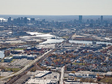
The Metro Boston region, an area where civic leaders have been at the forefront of climate resilience initiatives in recent years, is undergoing a comprehensive flood vulnerability assessment of its food distribution networks north of Boston. Much of the metro region’s food supply passes through two major distribution centers in the cities of Everett and Chelsea, just north of the Mystic River. The Metro Boston Climate Preparedness Taskforce, made up of 14 inner core cities and towns, as well as state, regional, and federal agencies, is organized through the Metropolitan Area Planning Council (MAPC). MAPC found two scientific partners who can build upon existing analyses of the region’s food system and climate vulnerabilities to develop a comprehensive report identifying flood risk exposure to the food distribution centers in Chelsea and Everett and their larger regional implications.
Project Team
The Community Lead

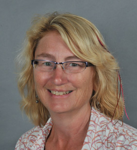
Axum Teferra joined the Clean Energy Division of MAPC in December 2014. As an Energy Planner, Axum is focused on renewable energy generation initiatives and on MAPC’s development of a regional climate preparedness and resiliency plan. Her areas of expertise include Climate preparedness and resiliency, renewable energy generation, cleantech innovation, energy efficiency, and climate equity.
The Scientist Liaisons

Dr. Ellen Douglas is a hydrologist, an engineer, and an associate professor at University of Massachusetts Boston. Her research utilizes computer modeling and data analysis to define and support sustainable management policies and practices related to water resources and climate change adaptation.

Chris Watson is a research fellow with the School for the Environment at University of Massachusetts Boston. His areas of interest focus around sea level rise and coastal flooding. He holds a particular interest in the applicability of his research to predict flood impacts in Boston in the coming century.
Status:
Complete,
Location:
Boston,
Massachusetts,
Managing Organizations:
Thriving Earth Exchange,
Project Categories:
Climate Change,
Flooding,
Natural Hazards,
Project Tags:
No tags