
Developing a Methodology for Measuring Changes in Albedo to Reduce Urban Heat Island Effect
Cambridge, Massachusetts, United States
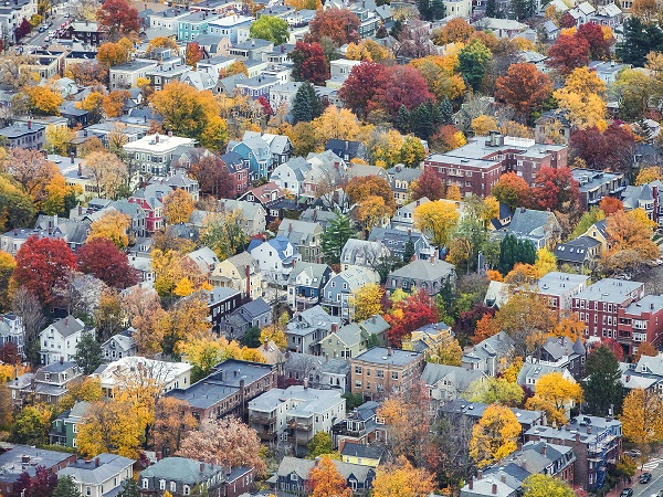
Photo courtesy of Kyle Klein
Results
The Team
- Julia Jeanty: Community Science Fellow, Thriving Earth Exchange,
- Drew Kane: Land Use Planner, Cambridge Community Development Department
- John Bolduc: Environmental Planner, Cambridge Community Development Department
- Mehdi Heris: Assistant Professor in Urban Policy and Planning at Hunter College
- Celeste Gambino: NASA DEVELOP National Program Boston Fellow, NASA DEVELOP National Program
- Sophie Barrowman: NASA DEVELOP National Program Summer Developer, NASA DEVELOP National Program
- Liam Bhajan: NASA DEVELOP National Program Summer Developer, NASA DEVELOP National Program
- Olivia Cronin-Golomb: NASA DEVELOP National Program Summer Developer, NASA DEVELOP National Program
- Nicole Ramberg-Pihl: NASA DEVELOP National Program Summer Developer, NASA DEVELOP National Program
The Initial Challenge
The City of Cambridge is working to plan and prepare for the impacts of climate change. The city is currently in the midst of developing a citywide Climate Change Preparedness & Resilience (CCPR) Plan in order to help the city adapt to the future and be better equipped to handle climate change. The CCPR Plan is developing strategies to reduce the Urban Heat Island Effect, and to ensure that the CCPR Plan is effective, the City is developing metrics that can be tracked to guide and adjust implementation over time. Cambridge is currently able to measure and track impervious surface area and urban forest canopy cover, but does not have the capability to track changes in rooftop albedo. Since February, the project team has been working to develop a replicable, practical, affordable, and consistent methodology to track changes in albedo over time to enable evaluation of whether the City is successfully reducing the Urban Heat Island Effect.
The Methods
The Cambridge team developed a Python procedure that calculates albedo from two sources: National Agriculture Imagery Program (NAIP) and Ortho imageries (geometrically corrected aerial photos). This process uses raster datasets in which the cell-size is 1 meter. The original photos (with different resolutions) were resampled to 1 meter. Both images offer four bands (blue, green, red, and infrared) that are required for calculating albedo. Our Python procedure uses all four bands of each imagery (NAIP and Ortho) to calculate the albedo at cell-level. Then the rasterized building polygons were used to mask the results and measure median albedo values for each building. The original resolution of Ortho imagery is 15 cm, which offers a very detailed photo of building rooftops. Converting this resolution to 1 m creates considerable noise due to shade effects of various objects on building rooftops. To minimize this noise, we used the 80th percentile of the albedo values of all cells for each rooftop. This process is repeated for three years (2010, 2013, and 2018). The team generated visuals to show how each resource can be used for tracking change in the city. The team’s Github page provides the codes to run this procedure and visualize the results.
In this study, the team used a variety of resources. They used National Agriculture Imagery Program (NAIP) images (downloaded from the Earth Explorer portal of U.S. Geological Survey), high resolution ortho images provided by the City of Cambridge (2010 images were downloaded from the Earth Explorer portal), and building footprints (downloaded from City of Cambridge’s open data catalog). These resources were used to calculate albedo for three years (2010, 2013, 2018).
Prior to the start of the NASA DEVELOP collaboration, the project team met on a monthly basis, in addition to meetings that were held on an as-needed basis. The project team began meeting more frequently once the DEVELOP team came on board, roughly on a weekly basis.
The Results
- Code provided by Dr. Mehdi Heris and used by the NASA DEVELOP team to determine albedo.
[caption id="attachment_24084" align="alignright" width="397"]
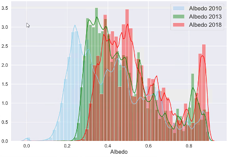 Figure 1: The histogram of rooftop albedo measurements for years 2010, 2013, and 2018[/caption]
 - Rooftop albedo maps showing rooftop albedo for three distinct years and the change in Cambridge rooftop albedo from 2008 to 2018.
- A nighttime land surface temperature record for summers in Cambridge from 2003 and 2019.
- Temperature anomaly maps for Cambridge compared to a portion of Eastern Massachusetts from 2004 to 2019.
- The Cambridge Urban Heat ArcGIS Online Dashboard.
- Additional science communication products, such as:
- Additional maps, imagery, and data to be used by the partner’s consulting agency for future UHI modeling
The project resulted in creating a replicable methodology that enables the City to map and track rooftop albedo over time. This expands the City’s capacity to manage the urban heat island effect and increasing climate change-driven heat vulnerability by making albedo another factor, along with urban forest canopy and pervious/impervious cover, that can be modified.
The results from mapping over time indicates that rooftop albedo has increased since 2010 which probably reflects improvements in the market availability of higher albedo roofing materials and the overall trend of green building design and use of the US Green Building Council’s Leadership in Energy and Environmental Design (LEED) standards.
The results will be used to inform the citywide Climate Change Preparedness & Resilience Plan and the recommendations of the Climate Resilience Zoning Task Force. The City will also make the data accessible to the public and property owners to help drive rooftop improvements to buildings.
Since the code developed by Dr. Meris will be open source, other communities and interested individuals can map rooftop albedo.
Reflections
The team notes that the following contributed to their success:
- Regular meeting times and frequent communication.
- Collaboration with NASA DEVELOP.
- Positive attitudes and eagerness to accomplish the tasks at hand.
If they were to do this project again, some things that they would do differently would be:
- To have a better understanding of the City’s capacity to support Mehdi (resolved by NASA’s collaboration).
- To have a realistic expectation for how timely projects can become/expecting project evolution & scope-creep.
Model limitations: The developed model uses a four band aerial image. Considering that the spectral resolution is low, the albedo measurements do not account for reflection in longer wavelengths. Furthermore, our model does not account for rooftop angels. A more sophisticated model can be developed to incorporate reflection in all directions and longer wavelengths. Another important limitation in this study is the use of ortho images from different years. These aerial images do not have consistent configurations and detailed metadata similar to satellite images. Even though we scaled the digital numbers, we observed inconsistent brightness in different years.
[caption id="attachment_24086" align="alignleft" width="391"]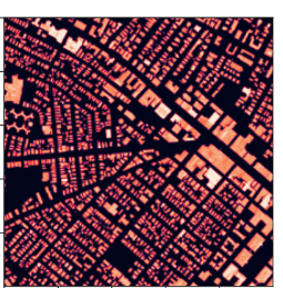 Figure 2: An example of rooftop Albedo measurement
Image Credit: Mehdi Heris[/caption]
Some advice for those considering pursuing similar community science projects:
Keeping an open line of communication is crucial. Being able to express when you need additional time to complete tasks, that a task is going well or is challenging, or that you would benefit from additional support can help alleviate many of the issues that might otherwise arise in a collaborative setting.
[caption id="attachment_24088" align="alignright" width="654"]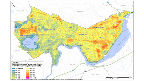 Figure 3: Urban heat islands in Cambridge, MA. Image Credit: Kleinfelder[/caption]
Description
The Urban Heat Island (UHI) Effect is a phenomenon that makes urban areas more vulnerable to the effects of high temperatures compared to less developed areas. As climate change progresses, cities like Cambridge, which has not historically been exposed to extreme heat, expects as a result of climate change to experience impacts to health, environment, and infrastructure. The UHI effect will therefore become an important factor to manage. Cambridge is a dense, diverse urban community of approximately 110,000 people that is home to academic institutions and a major life science sector. The city is part of the Boston metropolitan area, and like a lot of New England cities, Cambridge is dense and tightly packed. Approximately 60 percent of Cambridge’s land area is impervious – covered by buildings and pavement – with some areas having sparse amounts of public shading and tree cover, which contributes to the UHI Effect. Perhaps the worst suffering is being experienced by residents in neighborhoods with a particularly low percentage of tree canopy cover. Although the heat vulnerability problem is emerging since Cambridge currently has a cold weather climate, climate projections demonstrate a shift towards overall hotter temperatures during the summer months along with increasing humidity. According to Part 1 of the City of Cambridge’s Climate Change Vulnerability Assessment (CCVA), which focuses on the increasing risks of heat and flooding, the annual number of days with temperatures over 90 degrees Fahrenheit (90°F) may triple in Cambridge by 2030. By 2070, Cambridge may experience nearly three months of temperatures over 90°F, compared with less than two weeks in present day. Climate change poses a threat to Cambridge’s infrastructure, public services, public health, and economic well-being, so in light of these projections, the city is planning ahead.
Cambridge is working to plan and prepare for the impacts of climate change. The city is currently in the midst of developing a citywide Climate Change Preparedness & Resilience (CCPR) Plan, which is anticipated for an early 2020 release date. The premise of the CCPR Plan is that climate change is already happening and ignoring it is no longer an option for Cambridge. The city is currently designed based on the past climate. Community leaders want to design it to be adapted to the future and transform city to be better equipped to handle climate change.
As part of the CCVA and CCPR Plan, the City has developed projections for temperature, precipitation, and sea level out to 2030 and 2070. The CCPR Plan is developing strategies to reduce the Urban Heat Island Effect, mainly by replacing impervious surfaces with vegetated surfaces, restoring and expanding urban forest canopy, and deploying physical shading and reflective surfaces. To ensure that the CCPR Plan is effective, the City is developing metrics that can be tracked to guide and adjust implementation over time. The City is currently able to measure and track impervious surface area and canopy cover, but does not have the capability to track changes in surface albedo.
The main objective of this project is to develop a methodology to track changes in albedo over time to enable evaluation of whether the City is successfully reducing the Urban Heat Island Effect. The community would like this methodology to be replicable, practical, affordable, and consistent. More specifically, the community is interested in determining:
- How to measure albedo
- What data sources are needed and available
- What calculations can be done to assess albedo and how
- What indicators can be used to make a judgement for progress in Cambridge’s climate CCPR Plan
Cambridge is an engaged community in which stakeholders and the public are very involved with, and knowledgeable of, the planning processes and the proceedings of city government. Advisory committees, focus groups, public meetings have all been used to involve stakeholders and the public in the development of the CCVA and CCPR, and the community leaders are keen on maintaining this level of collaboration with the community.
A common issue with city planning is that many plans are conceived but do not come to fruition. The community would like to see a set of real expectations facilitated by measurable projects that are shared with the larger community in a clear and accessible manner. It is important to the city that this project serves as an example for how transparency can pave the way for true progress in city planning, and how collaborative visions for the future can transform their city into one better adapted to handle the inevitable effects of climate change.
Project Team
Community Leads
 Drew Kane is the Land Use Planner at the City of Cambridge Community Development Department. Prior to the City of Cambridge, he worked as a consultant in architecture and planning firms in Atlanta, New York and Boston. Drew’s areas of expertise includes public realm design, master planning, and regulatory development with an interest in waterfronts, resilience, and urban industrial districts. He is currently working on implementation of the recent citywide plan, Envision Cambridge, which serves as the city’s roadmap for inclusive and sustainable growth to the year 2030.
 John R. Bolduc is an environmental planner with the City of Cambridge Community Development Department where he manages climate change initiatives. He manages the City’s Climate Change Vulnerability Assessment and the Climate Change Preparedness and Resilience Plan; coordinates the Climate Protection Action Committee, an advisory group to the City Manager on local climate change policy and implementation; administers the Building Energy Use Disclosure Ordinance; and participates in a range of other municipal sustainability efforts. John has been with the City of Cambridge since 1997 and has over 30 years of experience in municipal sustainability and environmental protection. He holds a Bachelor of Science degree from the University of California at Davis and a Master of Arts from Tufts University in Urban and Environmental Policy.
Community Scientists
 Mehdi Heris is an environmental planner and works as a postdoctoral fellow at the University of Colorado Denver. Mehdi’s research interest is measuring the impact of urban form elements on environmental factors such as microclimates, air quality, and stormwater. He is an expert in modeling the impact of urban form elements on urban heat. Currently, he works on Ecosystem Accounting Using Earth Observation Data project that is funded by NASA. In this project, he has developed national ecosystem models including monetizing the impact of urban trees on cooling energy savings across the U.S. He uses advanced geospatial methods to run complex models at local and national scales. As a planner, he also studies the policy-making processes that shape our urban environments. Through studying regulatory tools such as zoning and design guidelines, he connects the science of urban ecosystems to the practice of planning.
 Celeste Gambino is the Massachusetts – Boston Fellow for the NASA DEVELOP National Program. She graduated from Bryn Mawr College in 2016 with a B.A. and graduated from Boston College in 2018 with a M.S., both in Geology. Her research focus was in geochemistry and paleoclimatology. Celeste has been with the DEVELOP Program since January 2019.
The NASA DEVELOP National Program is part of NASA’s Applied Sciences Program and addresses environmental and public policy issues through interdisciplinary research projects that apply the lens of NASA Earth observations to community concerns around the globe. DEVELOP is excited to partner with Thriving Earth Exchange on its Cambridge Massachusetts Albedo project! A team of four DEVELOPers will collaborate with Thriving Earth and partners at the City of Cambridge Community Development Department to analyze how Cambridge urban albedo has changed through time, and create various science communication deliverables to display results in interactive, user-friendly ways.
NASA DEVELOP team:
 Sophie Barrowman is a recent graduate with a degree in Geographic Science from James Madison University, and will start a master’s in the Fall at UC Davis. Her academic interests include GIS, urban sustainability, and agriculture. This is her second term with NASA DEVELOP and hopes to expand skills in coding and the applications of remote sensing.
 Liam Bhajan completed his undergraduate degree in Geology at Stanford University (’17) and is currently a graduate student at Boston College (’20) in Earth and Environmental Sciences. His research involves mapping land cover / land-use change in urban watersheds in order to further understand how these changes may impact the local hydrology. Overall, he is interested in understanding how remote sensing and GIS techniques can be used to better manage natural resources particularly focusing on water and agriculture.
 Olivia Cronin-Golomb received a BA in Earth and Environmental Sciences with a minor in Marine Science and an MA in Remote Sensing and Geospatial Sciences from Boston University (2020). She has focused her research on using a combination of remote sensing and GIS to study coastal biogeochemical processes by measuring optically-active constituents within the water column. She is especially interested in using geospatial data to understand how humans impact coastal health and what we can do to mitigate the effects of global climate change on coastal communities. Through this project, she would like to better understand how to use data visualization strategies to effectively communicate scientific results to policy makers. She is also excited to expand her knowledge of remote sensing and GIS to a more urban landscape.
 Nicole Ramberg-Pihl is interested in both the social and ecological issues that threaten the well-being of our planet. She holds a B.S. in Environmental Biology from Plymouth State University (2009), a M.S. in Biology from Plymouth State University (2012), and is currently completing her PhD in Ecology and Environmental Science at the University of Maine. As an NSF IGERT Fellow, she gained experience working on interdisciplinary teams that research complex issues surrounding extreme events stemming from abrupt climate change. It was during her first term with NASA DEVELOP in the Fall of 2019, that she learned to apply the unique perspective that remote sensing provides to address local environmental concerns. She enjoys working on interdisciplinary projects and strives to generate impactful science that informs adaptive management and policy.
Community Science Fellow
 Julia Jeanty is a 2018 graduate from the University of Florida with a dual degree in Environmental Geosciences and Sustainability Studies, as well as certificates in Geospatial Information Analysis and Meteorology and Climatology. Most recently, Julia worked at the American Geosciences Institute as a Geoscience Policy Intern, and then as a Talent Pool Intern at the American Geophysical Union.
Status:
Complete,
Location:
Cambridge,
Massachusetts,
Managing Organizations:
Thriving Earth Exchange,
Project Categories:
Climate Change,
Project Tags:
No tags