
Assessing sea level rise and flooding events to promote community engagement and action
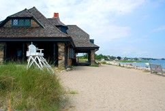
Greenwich, Connecticut, United States
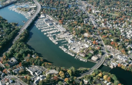
Aerial photograph of Greenwich, CT. Provided by Sarah Coccaro
This project will promote awareness of the local effects of sea level rise and flooding events in Greenwich, CT using data collected by local citizens for local citizens.
Description
The town of Greenwich is located in Fairfield County in southwestern Connecticut and home to 62,840 inhabitants as of 2019. It is best known for its proximity to New York City, the annual Town Party, the Greenwich Food and Wine Festival and a plethora of natural areas, parks and beaches. This coastal town is the largest on Connecticut’s ‘Gold Coast’ due to its many hedge funds and large financial service companies. Only a 50-minute train ride to New York City, the residents of this coastal town have access to all the excitements of city life without sacrificing the feeling of a New England town.
The town’s coastal location makes it a prime target for the adverse effects of flooding. Not only are Greenwich’s shoreline and marine ecology in danger, but the local oystering and fishing communities are at risk. Town beaches, local roads, park areas, and tidal ponds are regularly submerged. The public’s awareness of the immediate risks and danger to personal livelihoods is rising and should be nudged further into the direction of supporting local infrastructure changes that address said risks.
Currently the town is working on a longitudinal survey of tidal ponds and infrastructure systems in relation to a series of record breaking high tides and more frequent and severe storms. Kate Dzikiewicz, Bruce Museum Seaside Center Manager, Corinne Flax, Bruce Museum Manager of School and Community Partnerships and Science Curatorial Associate and Sarah Coccaro, the Conservation Resource Manager for the Town, believe this study could serve as a jumping off point for a long-term citizen driven project, focussed on monitoring tidal levels from multiple points throughout the Town, and developing an abatement plan.
The Project
The aim of this project is to encourage citizens to make connections between sea level rise, flooding events, extreme tides, and their personal livelihood. To that extent citizens will be involved in monitoring, recording, and analysing historical and current tidal data. The project consists of two interconnected phases.
Phase 1: Data collection and analysis
This first phase will focus on acquiring data to document changes to the local sea level, flooding events, and local tides. The data collection will be performed by groups of local citizens including local student groups, local families, and any eager volunteers. The data will be a combination of aerial photography, satellite records, photographs of popular town spots, historical data, oral anecdotes, tide gauge data, third-party studies, and other appropriate measurements. The final decision on which data to collect will be made in conjunction with the advising scientists. The data collection will take place over the summer and fall of 2021.
The local high-school Innovation Lab and other interested volunteers will use the collected data to create a report outlining the effects the recorded events have had and potentially could have on the local Greenwich community. The term report is used loosely here to describe any data analysis output that can be used during phase 2 of this project. The data analysis will be assisted by the advising scientist.
One additional long-term goal of this project will be to explore hosting a tidal gauge recorder in partnership with the United States Geological Survey.
Phase 2: Science communication
During this project phase the generated output from phase 1 will be used to spread awareness and promote community buy-in on topics surrounding sea level rise and flooding. Ideally, the results will be put in a local as well as broader context. The science communication portion of the project will involve an exhibition at the Bruce Museum, Greenwich Town Hall, or Seaside Center, a public talk series, and a First Sunday Science Seminar. Hosting the results on a local website will be explored as an option. These events will be scheduled for the fall and winter of 2021.
Summarizing, the community will participate in developing a citizen-driven science project that facilitates understanding the local effects of sea level rise, flooding, and tidal changes. They will share the project outcomes with locals, which will hopefully change public opinion on the adverse impacts on rising sea level.
Timeline and Milestones
- The project is set to take approximately 6-12 months
- The preparations are ongoing with involvement of the general public planned for the summer and fall.
- Key Milestones include:
- Developing the detailed terms of the data collection phase together with the advising scientist(s).
- Sharing the project details with the public to promote engagement.
- Hosting a kick-off & participant recruitment event at the Bruce Museum/Seaside Center in the summer.
- Presenting the results at a local exhibition
- Coverage in the local press
Project Team
Community Leaders
 Sarah Coccaro is the Conservation Resource Manager for the Greenwich Conservation Commission. She holds a B.Sc. in Marine Biology and Foregin Languages from Roger Williams University and a M.A. in Maritime Archaeology from Flinders University. Sarah’s work blends management, preservation and conservation of natural and cultural resources, while engaging town departments and community partners. Sarah serves on town committees, such as the Greenwich Sustainability Committee, Greenscape Committee, Open Space Committee, Green Schools Committee and local groups, such as the Friends of Pinetum, Pomerance, and Tuchman, and Pollinator Pathways. In her free time, Sarah volunteers with the Newtown Underwater Search and Rescue dive team and Lewisboro Sustainability Committee.
 Corinne Flax is the Manager of School and Community Partnerships at the Bruce Museum in Greenwich CT. She holds a B.A. in Art History from Drew University and a M.S.E. in Museum Education from The Bank Street School of Education. Corinne’s educational practice is grounded in object and place based learning, and embraces science and art as twin modalities of exploration and discovery. Corinne works with community partners to create engaging programming and learning opportunities for schools, community centers, after school programs and adult learners. Corinne presented at the NYCMER Annual conference in 2020 and 2015, the 2018 NEMA conference and has been published in the NEMA Journal and the Journal of Museum Education.
 Kate Dzikiewicz is the Science Curatorial Associate and Seaside Center Manager at the Bruce Museum, located in Greenwich, CT. She has a diverse academic background, encompassing both molecular biology and paleontology. She received a B.S. in Biology from the University of Virginia, where she studied microRNA, and after a year spent as an intern at the National Museum of Natural History, went on to North Carolina State University to pursue graduate studies in molecular paleontology. She graduated with her Master in 2014, briefly returned to the National Museum of Natural History to work in the Education Department, and then joined the Bruce Museum as the Paul Griswold Howes Fellow. In 2019, she became the Seaside Center Manager and Curatorial Associate at the Bruce, and now shares her time between seaside education and exhibition curation.
Community Scientist
 Dr. James O’Donnell is a Professor at the University of Connecticut and the Executive Director of CIRCA (Connecticut Institute for Resilience & Climate Adaptation). His research focuses on understanding the physical processes that determine the circulation and transport of materials in the coastal ocean. With students and research associates, he is currently involved in both the construction and testing of models and the development of technology to make observations. He is also interested in fundamental geophysical and environmental fluid dynamics and the application of mathematical and statistical methods to the development of models of biogeochemical processes.
As Executive Director of CIRCA, he is responsible for bringing together the world class research and outreach capabilities of the University of Connecticut and the extensive practical experience of the Connecticut Department of Energy and Environmental Protection to create and disseminate practical and sustainable strategies to enhance the resilience of the built environment while protecting natural ecosystems in Connecticut and the northeast.
Community Science Fellow
Dr. Kim Drouin is a Physical Oceanographer and Postdoctoral Associate at Duke University working with Dr. Susan Lozier. Her current research focuses on the pathways of the upper-ocean in the South Atlantic. She holds a M.S. in Meteorology and Physical Oceanography and a B.S. in Marine and Atmospheric Sciences from the University of Miami. Kim is the Director and Co-Founder of the ELEMENT program at Duke, an after-school outreach and mentoring program created to enhance exposure to the STEM field for underrepresented elementary school students. Passionate about education and community outreach, Kim also served as the Camp Coordinator for Duke’s Environmental Science Summer Program. Last year, Kim was selected for the Duke Environmental Impact Fellowship that focuses on enhancing leadership, self-awareness, teaching, and communication skills.
Collaborating Organizations
Bruce Museum
 Sitting high on a hill overlooking Greenwich Harbor, the Bruce Museum offers a changing array of exhibitions and educational programs that promote the understanding and appreciation of art and science.
The Bruce Museum was originally built as a private home in 1853 for lawyer, clergyman and historian Francis Lister Hawks. Over the years, the community, through its generosity, has built the Museum collection to nearly 15,000 objects representing the arts and sciences.
The Museum is immersed in a transformative $60 million capital expansion plan, soon to be highlighted by the new construction of the contemporary and spacious William L. Richter Art Wing and its leading-edge galleries and inventive public spaces to educate, entertain, and enchant the community’s increased demand for an even greater museum. With its Endowment growing by $15 million, the reimagined Bruce will be enjoyed and sustained for generations to come.
Seaside Center
 The Seaside Center is a beachside marine education center located in Greenwich Point Park, Old Greenwich, about 6 ½ miles from the Bruce Museum. The Seaside Center is typically open from the last week of June through Labor Day, six days a week, with fish tanks, dioramas portraying local species, touch tanks, and daily education programs free and open to the public. Education themes focus on the ecology of Long Island Sound, as well as more general environmental issues.
During the summer of 2021 and partnering with the Make-A-Wish Foundation, Luke’s Wish will open at the Seaside Center, an interactive display showcasing the effects of climate change and sea level rise on the local Greenwich shoreline and Long Island Sound. This display will encourage visitors to consider ways they can reduce their personal carbon footprint.
Town of Greenwich
 The town of Greenwich, Connecticut consists of several distinct neighborhoods, such as Banksville, Byram, Cos Cob, Glenville, Mianus, Old Greenwich, Riverside and downtown Greenwich. Greenwich is one political and taxing body and is governed by a Board of Selectman and a Representative Town Meeting (RTM) form of government.
In addition to the selectman’s offices, the RTM and the Board of Estimation and Taxation having governing power are a number of independent volunteer boards and commissions, which also have influence over how the town is run. These boards and commissions include: Architectural Review, Board of Ethics, Board of Health, Board of Standards & Appeals, Commission on Aging, Conservation Commission, Flood & Erosion Control, Historic District, Housing Authority, Inland Wetlands & Watercourses Agency, Nathaniel Witherell, Parks & Recreation, Planning & Zoning, Planning & Zoning Appeals and Shellfish Commission.
MyCoast
 MyCoast is a tool for local citizens to document flooding events, storm damage, king tides, beach cleanups, and more. Since 2013, thousands of people across the US have submitted over 23,000 photos via the free MyCoast app. State and municipal decision makers, emergency managers, and policy makers subsequently use these photo reports to make more informed decisions on protecting people, property, and the nation’s coastline ecosystems. As such, MyCoast acts as a bridge to connect citizens, scientists, and decision-makers, all working towards the same goal of ensuring a sustainable future.
Status:
Complete,
Location:
Connecticut,
Greenwich,
United States,
Managing Organizations:
American Meteorological Society,
Project Categories:
Climate Change,
Flooding,
Project Tags:
No tags