
Analyze Urban Heat: Relating it to Community Impacts, Community Resources, and Tree Canopy Cover
Montgomery County, Maryland, United States
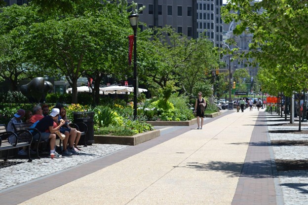
A woman walks down a sunny, urban sidewalk in Montgomery County, Maryland on a hot day while several people are seated in a small area of shade. Credit: Montgomery County, MD Department of Environmental Protection.
As more areas become urbanized and climate change creates new weather extremes, Montgomery County, Maryland is concerned about the impacts of urban heat island on the county. We are interested in understanding how urban heat may disproportionately impact communities in Montgomery County, how that relates to tree canopy cover, and needs and potential locations for public cooling centers. We are interested in analyzing intersections in data describing urban and community heat, tree canopy, demographics, and cooling center locations. We also will want to build a GIS tool or Geodatabase that presents this data well as results of any analyses. This tool will be used by Montgomery County and local advocacy groups to identify areas of high vulnerability and help prioritize tree planting areas, as well as locations for cooling centers; this tool may also be useful to residents in helping them understand how they can escape the heat.
Description
About the Community
Montgomery County, Maryland includes many small cities and suburban areas and is part of the Washington D.C. metropolitan area. The county also includes an agricultural reserve and extensive park system. The county is the most diverse jurisdiction in the State. However, the county is also marked by vast wealth disparities between the wealthiest residents and other communities with high poverty. The county has tremendous scientific resources in large part due to federal facilities located in the county (such as FDA, NIST, NOAA, and NIH) and is largely a progressive jurisdiction; however, not all residents have a seat at the table. The Metropolitan Washington Council of Governments predicts significant population, household, and employment growth within the county until at least 2045, so it is pertinent to understand how urban heat is impacting and will impact the county.
We understand that urban heat may be disproportionately impacting some communities in Montgomery County in part due to a lack of tree canopy cover. Simultaneously, mature canopy trees and forests are also being lost in developing areas, while reforestation mostly often occurs along stream valleys or within conservation areas. These two ongoing changes lead to large impervious areas with few and unprotected trees, causing heat island pockets throughout the county. Much of our understanding about these intersections is anecdotal, so through this project, we would like to use data to quantify how and where urban heat is impacting Montgomery County.
About the Project
We would like to build a tool that helps Montgomery County to understand urban heat, locations of all heat islands, how heat may disproportionately impact some communities, and how heat relates to tree canopy cover and impervious surfaces. This tool will be used by county employees, and potentially additional government agencies such as larger State organizations, local municipalities, and local advocacy groups. The tool should: identify areas of the county with greater vulnerability to urban heat; relate data to the county’s Climate Action Plan to identify vulnerable communities and later link these impacts to health risks; and identify where diminished tree canopy could be exacerbating urban heat issues. These results will help us to prioritize tree planting, identify locations for future cooling centers (such as outdoor spray areas, public water fountains, shaded zones, public buildings, etc.), develop stronger individual and group tree protection measures on both private and public lands, and implement other heat-management strategies and resources. The tool may also be useful to county residents, particularly those impacted by urban heat. We also expect for the tool to align with other county urban heat and land use initiatives.
We anticipate that the following four prongs of data will be used to construct the tool and conduct analyses: 1) urban heat data, 2) tree canopy data, 3) demographics data (such as locations of disadvantaged or lower income communities, vulnerable populations, race and ethnicity, and health data), and 4) locations of cooling centers, such as public buildings like libraries and recreation centers. Montgomery County has access to some data relating to all four of these prongs, but we need the assistance of one or more technical expert(s) in understanding the relevance and usability of our data for this project, generating additional data needed for this project, analyzing the data, and building a GIS tool and/or Geodatabase presenting the results of the analysis with metadata. In the production of this tool, we will need to collaborate with GIS-specialized employees in the Department of Environmental Protection (DEP) and/or Park and Planning (M-NCPPC) so it will fit within current county systems, and the methods of data collection and analysis should be clearly outlined so it could be replicated in the future by county employees.
Montgomery County has been selected for a 2022 NOAA heat mapping grant. This project aims to determine urban heat islands through temperature and humidity measurements. The data will be collected through volunteer effort under NOAA guidance in August 2022. Once this data has been collected, we would like assistance in analyzing it independently and understanding the data in terms of other urban heat data (including local maps, local surface temperature readings, and national datasets). Most importantly, the technical expert should assist with relating the urban heat data to the other three prongs of data. Additionally, we have access to data on the location of tree cover for multiple years, and will have access to NAIP 4 band lidar imagery investigating tree cover. However, we would like the advice of a technical expert in deciding if it is useful or feasible to pursue a more granular tree canopy data set that includes information such as tree health or forest vs non-forest tree canopy. Montgomery County should be able to provide the locations of cooling centers within the county and demographics data.
The County is also receiving technical assistance through the Urban Sustainability Directors Network’s Nature-Based Climate Initiatives (formerly the Urban Drawdown Initiative), utilizing its Managing Urban Landscapes for Climate Action Strategy Development Guide to establish a framework that evaluates the County’s existing programs, plans, and policies to identify gaps in our current capacity and create a comprehensive roadmap for the Climate Action Plan on Natural Climate Solutions. This, in turn, will help the County evaluate existing prioritization and measurement tools, such as the Trust for Public Land’s Carbon Management Tool for Urban Decision Lands, and inform development of a tailored tool that meets the County’s specific needs. The project kicked off during Spring 2022 and is scheduled to be completed in Fall 2022. Ideally, this initiative should dovetail with the work being conducted by the Thriving Earth Exchange project.
Timeline and Milestones
To understand our timeline and milestones, we would like to meet with a technical expert to identify what granular data collection is useful and feasible. We recognize that the project should be completed within 6-18 months.
Project Team
Community Leads
Adriana Hochberg serves as the Climate Change Officer for Montgomery County, Maryland and as Acting Director for the Department of Environmental Protection (DEP). She leads Montgomery County’s efforts to combat climate change while building a healthy, equitable, and resilient county. Ms. Hochberg coordinated the development of the Climate Action Plan, a strategic roadmap for the County to cut community-wide greenhouse gas emissions by 80 percent by 2027 and reach zero emissions by 2035.

Marianne Souders serves as the Acting Director for the Office of Emergency Management and Homeland Security (OEMHS) where she sets the strategic direction for the office and oversees the office’s budget and grant projects. She worked on the Climate Adaptation and Carbon Sequestration workgroups during the initial phase of the climate action plan. She is the Treasurer of the Maryland Emergency Management Association. Marianne grew up in Maryland and served for over 15 years in Anne Arundel County as an Emergency Medical Technician-Paramedic Lieutenant and 911 Shift Supervisor. Marianne is a Certified Emergency Manager (CEM) and has a Bachelor’s in Emergency Health Services from the University of Maryland and a Master’s in Emergency Management from Millersville University.

Tina Laboy (she/her) serves as the Acting Planning Division Chief in the Office of Emergency Management and Homeland Security (OEMHS) where she leads several emergency preparedness projects to promote community resilience. Tina is a member of the County’s Climate Leadership Team, focusing on climate adaptation and climate resilience. Tina is a Certified Emergency Manager (CEM). She holds a Bachelor’s in Meteorology and a Master’s in Emergency Management from Millersville University. She also holds a Master’s in Law and Policy of Crisis Management and Homeland Security from the University of Maryland Francis King Carey School of Law.

Michael Boldosser is a veteran of the US Air Force, with over 21 years of active duty service, half of which was dedicated to piloting a flying gas station for midair refueling. He has over 15 years of emergency management experience at the county level, the last five at the Montgomery County Office of Emergency Management and Homeland Security. Michael has a Bachelor’s degree in Chemistry, a Master’s in Aeronautical Science and is a Certified Emergency Manager.

Mara Parker (she/her) works as a grants coordinator in the Office of Emergency Management and Homeland Security (OEMHS) in Montgomery County. She is a member of the County’s Climate Leadership Team, where she worked with the Climate Adaptation and Carbon Sequestration workgroups. Before coming to OEMHS she worked for over ten years as a senior legislative aide at the Montgomery County Council. Mara grew up in Alaska and Washington state, where she studied Geography at the University of Washington. In her free time she enjoys languages, hiking, kayaking and travel.

Steve Findley has held various positions with the Maryland-National Capital Park and Planning Commission for over 32 years. He has worked with the Montgomery County Parks Department as a Natural Resources Specialist and as a Nature Center Director, and with the Montgomery County Planning Department as an Environmental Planner. He currently works as a Planner IV with the Midcounty Planning Division focusing primarily on environmental planning issues, analyzing environmental conditions, making sustainability recommendations for Master Plans, modeling greenhouse gas emissions, and reviewing developments for compliance with the Montgomery County Forest Conservation Law and other environmental policies and regulations. In 2020, he became a Certified Climate Change Professional, a credential granted jointly by the Association of Climate Change Officers and the State of Maryland.

Zach Dreyer is the Climate Change/Flood mapping GIS Specialist for Montgomery County’s DEP. He graduated from the University of Richmond with a bachelor’s degree in Economics and Geography, and earned a master’s degree in Environmental Remote Sensing at the University of Trier in Germany. Earlier in his career he held a variety of positions including park ranger in the Everglades, GIS planner for Maryland State, coffee shop barista in Lambertville, NJ, agroforestry volunteer in Africa with the Peace Corps, GIS Transportation Planner for Montgomery Planning, and bartender at an Irish Pub in Germany. These days you can find him enjoying one of his hobbies like baking bread, mountain biking on the trails around the county, videogaming, or off playing soccer.
Community Scientists

Jean-Michel Guldmann is Professor Emeritus and Academy Professor of City and Regional Planning at the Knowlton School of Architecture (KSA), where he has taught from 1977 to 2012 and served as KSA Interim Director from 2005 to 2007. He has a Master’s in Industrial and Systems Engineering from the Ecole des Mines, Nancy, France, and a PhD in Urban and Regional Planning from the Technion-Israel Institute of Technology, Haifa, Israel. He has taught courses on optimization, decision analysis, population/economic forecasting, and energy and regional modeling at OSU, Capital Normal University in Beijing, and Gazi University in Ankara. He has supervised to successful completion the dissertations of 31 PhD students, including 6 students since his retirement in 2012. He has also hosted and mentored six Visiting Scholars from China and Turkey. His current research focuses on the analysis and modeling of the urban heat island and its mitigation, the role of green infrastructure in urban sustainability, air pollution from transportation and other sources, urban energy consumption, and land-use change dynamics. His research methodologies include spatial econometrics, simulation, and optimization, with, as input, big geospatial data (LiDAR, remote sensing, Census, cadaster). He has published a book entitled Industrial Location and Air Quality Control: A Planning Approach (John Wiley), 100 peer-reviewed journal articles, and 2 book chapters. He has been a member of the OSU Emeritus Academy since 2014.

Dr. Hari Kandel is an Assistant Professor in the School of Natural Resources and Environment at Lake Superior State University (LSSU), Michigan. He teaches geology, environmental science, and GIS courses at LSSU. His research interests span studying human-environment interface with a focus on land use/land cover change and its hydrologic impacts. He extensively uses remote sensing products and spatial analysis techniques in GIS for modeling processes related to hydrologic and human-environment alteration. He is a native from Nepal where he got his educational degrees up to MSc in Geology, continued to receive his MS in Geology/ Graduate Certificate in Geospatial Technology from Bowling Green State University, Ohio, and a PhD in Geology (Hydrologic Modeling and Geospatial Applications) from Florida International University, Florida. He enjoys being in nature: visiting places, hiking, cycling, playing volleyball; working with communities; getting updated with news; and occasionally watching sports.

Dr. Bumseok Chun, Ph.D., is an Associate Professor and Acting Chair in the Department of Urban Planning and Environmental Policy, specializing in urban analytics for interconnected human–environment systems. His expertise includes statistical simulation using spatial econometrics and the application of AI/ML techniques in digital twins. Dr. Chun earned his Ph.D. in City and Regional Planning from The Ohio State University and completed post-doctoral research at Georgia Tech’s Center for Geographic Information Systems before joining the faculty at Texas Southern University.
Driven by a commitment to impactful research, Dr. Chun focuses on developing practical, preventive interventions that identify environmental determinants and propose solutions through advanced geospatial and statistical modeling. His work integrates environmental studies with technological innovation, particularly in areas such as microclimate change, satellite-derived air pollution, environmental impacts of emerging transportation systems, and public health risks across mega-region areas using urban big-data analytics.
He is currently engaged in several major initiatives, including funded research projects with the Texas Department of Transportation (TxDOT), NASA-funded environmental studies, and The Gulf Scholars Program (GSP).
Community Science Fellow
Sydney Shelton (she/her) is a PhD candidate in geology at the University of Maryland. Sydney completed a B.S. in Environmental Science and Sustainability Studies at Rensselaer Polytechnic Institute, where her senior thesis focused on how researchers can overcome academic hurdles and participate in community science. In her free time, she enjoys hiking, biking, and traveling to any location with snow.
Status:
Complete,
Location:
Maryland,
Montgomery County,
United States,
Managing Organizations:
No organizations
Project Categories:
Natural Hazards,
public health,
Project Tags:
No tags