
Mapping the extent of the Tar Creek Superfund Site and other potential risks
Ottawa County, Oklahoma, United States
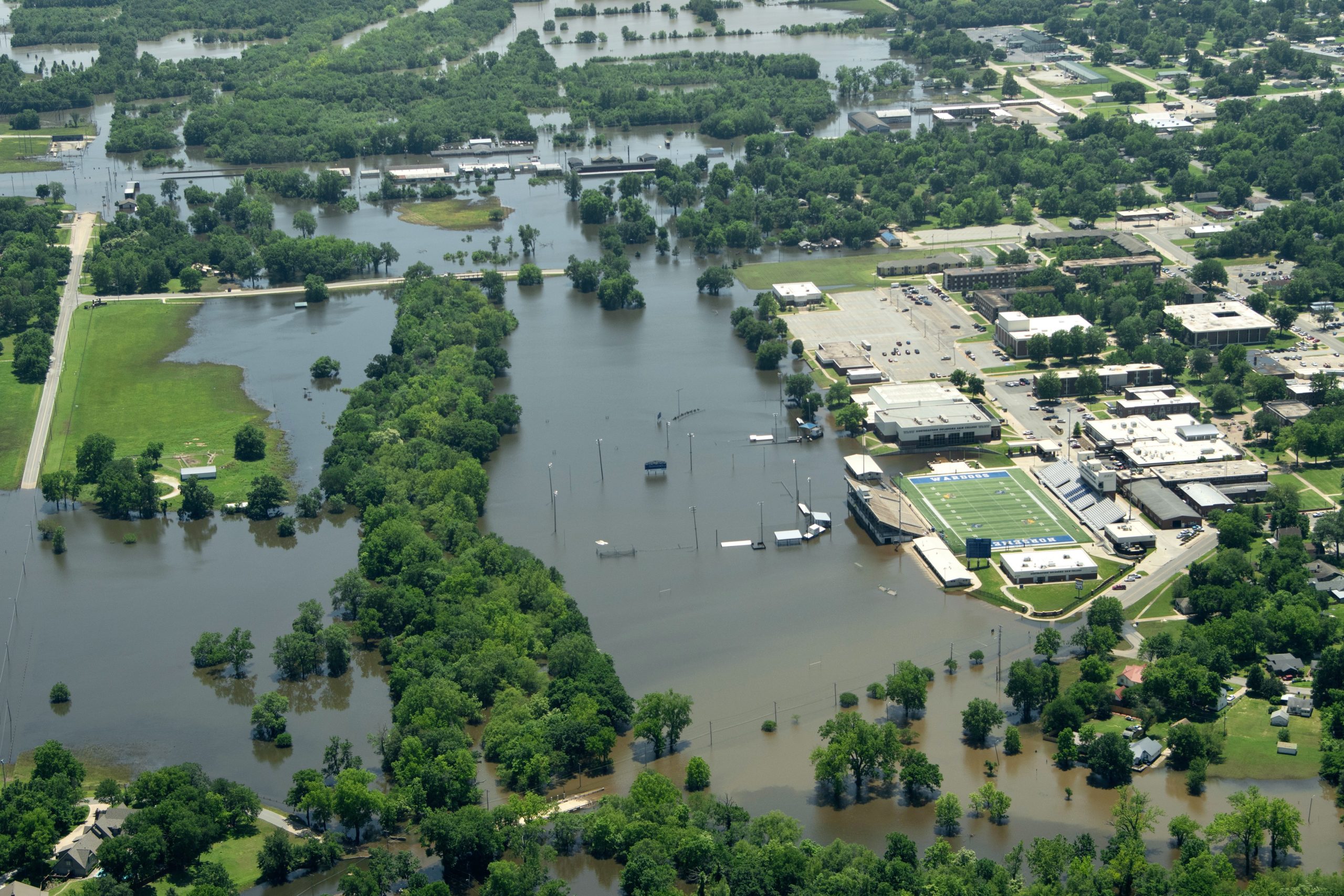
Flood waters cover areas in Miami, Oklahoma, May 30, 2019 (Photo by J Pat Carter/LEAD Agency)
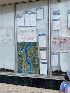
From September 2020 – August 2023, we developed an interactive flood map of Ottawa County, Oklahoma to share with residents. The map illustrates which households may be located within a flood zone, and it includes additional data layers with information on tribal boundaries, land parcels, and more. To share the map with residents we made it publicly available online (at http://bit.ly/LEADfloodmap), and we distributed USB drives of the map layers to residents at community events throughout Ottawa County. This project has successfully increased residents’ awareness of flood risks and environmental harms. Additionally, with the project team’s collaborative process the work has led to additional ongoing research opportunities and connections.
Results
This project remains in progress, but you can view the interactive map developed by the project team here.
Description
About the Community
Local Environmental Action Demanded (LEAD Agency) is a community-led non-profit environmental justice organization founded in 1997. The organization focuses on ensuring that the northeastern Oklahoma region is safe for all community members. LEAD Agency looks at not only the environment, but also at how community members interact with and are shaped by the environment and environmental changes. Additionally, the organization has longstanding partnerships with institutions and universities such as the Harvard School of Public Health, Tulsa University, and Mount Sinai Hospital.
LEAD Agency has an office in Ottawa County, the northeasternmost county in Oklahoma. The county’s 31,000 residents live in several small towns and surrounding rural areas, and while many residents identify as white, the county is home to nine federally recognized Indian tribes and Native Americans make up over 20% of the population. The community has a long history tied to mining. After 80 years of operating the world’s largest lead and zinc mine, the industry moved on in the 1960s and ‘70s, leaving behind 75 million tons of lead-contaminated tailings piles, also known as “chat”. For the last 40 years, one million gallons of mine water has discharged daily into Tar Creek.
LEAD Agency’s community science project is centered on impacts stemming from the Tar Creek Superfund Site. Designated in 1983 and encompassing the entire area of Ottawa County, OK, over $300 million dollars have been spent cleaning the Tar Creek Superfund Site. Nevertheless, children continue to suffer from lead poisoning, the creek is still orange, and chat piles loom on the horizon. LEAD Agency believes that the EPA’s conceptual site model, which determines the source, transport, and fate of all pollutants from the site and guides remediation efforts, is outdated and omits key factors that leave residents at risk of further health impacts.
The Project As It Happened
In the early stages of the project, Rebecca Jim, Earl Hatley, and Jessica Tran scoped what this project could look like and sought to identify what potential questions could be answered through a Thriving Earth Exchange Community Science Project. After determining our goals, we recruited and on-boarded our scientists, Dr. Kate Meierdiercks and Jim Kuipers, and began doing an “inventory” of what data layers were available and what is actually feasible. This helped us narrow down our goals into a realistic and feasible project.
Then, for most of our project’s lifetime, we worked on the interactive map while simultaneously presenting preliminary findings and insights at conferences such as the AGU Fall Meeting and The National Tribal and Indigenous Climate Conference. We sought out and received grants from 500 Women Scientists to support our project, and in the summer of 2022, we hired two undergraduate summer interns from Siena College.
When the map was ready to be shared and distributed, we developed a tutorial guide to accompany the map. In order to ensure that as many residents as possible could access the map regardless of wifi connectivity, we distributed it via a public link and through physical USB memory drives which had pdf files of the map as well.
This project was transformational for both the residents of Ottawa County and the project team. Residents benefited because they gained access to information about their community which was previously inaccessible. Additionally, this project allowed residents to explore their direct potential for flooding in the future. For the project team, this work allowed us to better understand the potential of community engaged science, and it gave us the skills and experiences to continue with this work in other roles and spaces.
This project has built the foundation for continued ongoing partnerships between the project team. Dr. Kate Meierdiercks is continuing to provide technical advice and support to LEAD Agency staff and volunteers in order to ensure a smooth transition of the map ownership and to expand LEAD Agency’s capacity to revise and manage the map in the future. Additionally, this project’s strong collaborative environment has led to other research projects, including Jessica Tran’s doctoral research with LEAD Agency on the value and efficacy of community engaged research in environmental justice advocacy.
Ultimately, through this work we collaboratively came up with a project which will continue to support LEAD Agency’s future research and advocacy work. By continuously reevaluating our expectations, we were able to adapt to new ideas and let those conversations inform the scope of our work. A unique aspect of the Thriving Earth Exchange Model that supported the project’s success was having the Community Science Fellow, Jessica Tran, hold the project team accountable and on track through each stage of the work. Additionally, by having flexible funding sources, the project team had the ability to pursue new questions and ideas.
The interactive map has been integrated in LEAD Agency’s other research projects and collaborations, including a local survey of well water property owners. Additionally, the Vermont Law and Graduate School has submitted comments on behalf of LEAD Agency about future dam relicensing proposals, and in their submission cited the flood map. The map continues to be a source of useful information for LEAD Agency’s ongoing work.
Read more about their project here.
Secrets to Success and Lessons Learned
- Rebecca Jim: Our community needed to SEE the issues impacting their lives and with that knowledge understand the urgency to take actions at pivotal times to protect their property and improve their lives. This project took us from inception to action.
- Martin Lively: This project showed me what is possible when a funded project need not be clearly defined or precisely delineated during the application stage. Our work has had more impact than I’d imagined possible precisely because we did not have to know its exact shape to secure funding. In our early meetings we explored together the realm of the possible and built a community resource far more valuable than anything we’d have proposed at the beginning.
- Earl Hatley: Our drive to demonstrate the flooding impacts to our community and the connection between the lake/watershed flooding and the Superfund Site, drove us to develop the map. However, once we began, the map took on a life of its own as more layering ideas developed and we could actually see what we were working with. We had no idea when we started what a wonderful and powerful tool we had developed for our community and our work. We can use it for most environmental issues we work on in the watershed, and I am able to use it as a tool, and example of community science, in my organizing work around the country. It has helped other communities. We are very grateful for this gift of true collaboration!
- Kate Meierdiercks: If I were to do this project again, I would spend more time at the beginning of the project learning about the community and all of the wonderful work that is ongoing before jumping right into mapping. I might ask, “what are the three things I need to read or watch to get to know your community better?” I would try to visit the project location earlier on.
- Jessica Tran: Our project team relied on open communication and reflections to not only further our work, but also to share gratitude and appreciation for each other’s effort. This helped foster a collaborative team dynamic that was rewarding and joyful to work in.
Timeline
- September 2020: LEAD Agency and Jessica Tran were matched through AGU TEX as a part of the Science, Policy, and Engagement Cohort. As a part of this cohort, they received $10,000 in project funds. They began to meet regularly through Zoom to develop goals for the project.
- February 2021: Kate Meierdiercks and Jim Kuipers joined the project team as Community Scientists. The group began meeting on Zoom for one hour, every two weeks to create the map.
- March 2021: Jessica Tran received the 500 Women Scientists Fellowship for the Future Award, which granted the project team an additional $2,500 in research funds.
- June 2021: A preliminary draft of the map was completed.
- July 2021: The project team met with the City of Miami, OK to show preliminary drafts of the map and get feedback.
- December 2021: The project team shared an oral and poster presentation at the AGU Fall Meeting on our research process.
- May 2022: The project team presented a poster at the C*Sci Conference on interactive digital maps as tools for storytelling.
- August 2022: The project team gave an oral presentation at the National Tribal and Indigenous Climate Conference on mining on Indigenous lands.
- October 2022: At the Tar Creek Conference, hosted by LEAD Agency, the project team shared and distributed the map to residents, regulatory officials, and other conference attendees. At this event, Dr. Kate Meierdiercks presented a tutorial on how to navigate the map.
- December 2022: The project team shared a poster presentation at the AGU Fall Meeting on iterative authorship practices.
- February 2023: Jessica Tran traveled to Oklahoma to meet with LEAD Agency in person for the first time.
- February 2023: After discussing how we’ve accomplished most of our original goals, the project team decided to begin concluding the work.
- March 2023: The project team received the ESRI GIS Mentorship Grant which gave LEAD Agency licenses to utilize ArcMap. This began the transition of map ownership to LEAD Agency.
- March 2023: LEAD Agency launched their new website which featured the flood map and a survey on residents’ flooding experiences.
- May 2023: Kate Meierdiercks began transferring the map to LEAD Agency and training LEAD Agency staff and volunteers how to manage the map.
- June 2023: Kate Meierdiercks traveled to Oklahoma to meet with LEAD Agency in person for the first time.
- August 2023: After transferring the map to LEAD Agency, the project concluded.
Project Team
Community Leaders
Rebecca Jim has served as LEAD Agency’s Executive Director since its incorporation in 1997. Holding a B.A. in Behavioral Sciences and M.A. in Education, Counseling, she was formerly the Indian Counselor for Miami Public Schools sponsoring the Cherokee Volunteer Society that started the Tar Creek Project. She asked Earl Hatley to serve as a consultant with the student group’s work, and then in 1997 they, with other residents, co-founded LEAD Agency. Rebecca is a member of the Cherokee Nation and is recognized as the Tar Creekkeeper by the Waterkeeper Alliance. She has co-edited Making a Difference at the Tar Creek Superfund Site, Community Efforts to Reduce Risk, and other publications featuring collected art, poetry, and writings that continue to inspire others to action.
 Earl L. Hatley is co-founder of LEAD Agency. He was the Executive Director for the Oklahoma Toxics Campaign when in 1993 he was asked by Rebecca Jim to become a technical advisor to her Cherokee Volunteer Society at the Miami High School. As more residents became involved, in 1997 LEAD Agency was incorporated. Earl was the first Board President for LEAD Agency until 2003 when he stepped down to become the Grand Riverkeeper. Earl still serves as the Grand Riverkeeper and technical leader for the staff at LEAD Agency. Earl is a well-trained organizer with 35 years experience in organizing and providing technical assistance to Indigenous and non-Indigenous non-profit groups and tribes in the US (including Alaska), with academic training that includes a MA in Political Science and ABD in Environmental Science.
Martin Lively is the Grand Riverkeeper with LEAD Agency. He grew up in Miami, Oklahoma, and has family roots there going back four generations. He has supported LEAD Agency’s environmental justice work since the 1990s as a volunteer and a law school public service fellow intern. In his first career, Martin practiced law in Georgia for almost a decade. After moving back to Oklahoma in 2012, he renewed his ties with LEAD Agency, working as an AmeriCorps VISTA for three years before becoming the Grand Riverkeeper. Martin holds a B.A. in English from Grinnell College and a Juris Doctor, Certificate in Dispute Resolution, and a Public Service Fellow Certificate from The Ohio State University Moritz College of Law. When time allows, Martin can be found backpacking in the Ozarks or traveling the middle of the country on long-distance solo bicycle tours.
Community Scientists
Dr. Katherine Meierdiercks is Associate Professor of Environmental Studies and Sciences, and Director of the Academic Center for Sustainability at Siena College, Loudonville NY, where she teaches courses in watershed management; environmental field techniques; environmental research methods; Geographic Information Systems (GIS); and analysis techniques for soil, air, and water. She received her B.S. in Civil Engineering from Tufts University and her Ph.D. in Environmental Engineering from Princeton University. For the past several years, she and her students have been collecting field data and doing GIS mapping in the Kromma Kill and Patroon Creek watersheds, both tributaries to the Hudson River. She serves as President of the Board of the Hudson River Watershed Alliance, a regional nonprofit whose mission is to, “unite and empower communities to project our shared waters.”
Jim Kuipers is a mining environmental consultant, and the principal and a consulting engineer with Kuipers and Associates based in Wisdom, Montana. He received a B.S. from Montana College of Mineral Science and Technology in mineral process engineering, and is a registered professional engineer in Colorado and Montana. He grew up in a mining family and has worked on mining and environmental projects including project development, engineering design, permitting, operations, reclamation and closure, water treatment and financial assurance for over 40 years. Since 1996, his primary work has been as a consultant providing engineering and other technical expertise to governmental and non-governmental organizations relative to hardrock mining and other extractive resource environmental issues.
Community Science Fellow
Jessica Tran is the Thriving Earth Exchange Community Science Fellow from the Science, Policy, and Engagement cohort. As a fellow, her role is to facilitate a collaborative, co-developed community science project that results in on-the ground impact in the local community and connects science to action. Jessica graduated in 2019 from Stony Brook University with a B.A. in Environmental Design, Policy, and Planning and a minor in Coastal Environmental Studies. Her previous experiences include researching community perceptions of climate change with the St. Paul Tribal Government’s Ecosystem Conservation Office, analyzing managed retreat policies through Stony Brook University’s Sustainability Department, and examining traditional ecological knowledge’s role in the southwest as a Doris Duke Conservation Scholar at Northern Arizona University. Jessica’s passion for her work stems from her identity as a first generation Asian American, and she finds resilience and strength in community, oceans, and art.
Additional Partner

Alexis Hidalgo is the Program Manager for Anthropocene Alliance, the nation’s largest coalition of frontline communities fighting for climate and environmental justice, of which the LEAD Agency is a part of. Alexis is based in Miami, Florida, and has been an environmental justice organizer since graduating from UC Berkeley in 2018. She hopes to support in any way possible the incredible work that Rebecca and Earl are doing to merge science and advocacy in their community.
Collaborating Organizations
![]() Anthropocene Alliance is the nation’s largest coalition of frontline communities fighting for climate and environmental justice composed of 70 communities in 22 states and Puerto Rico. They assist communities in understanding and addressing the impacts of flooding, water contamination, air pollution, and wildfires. The Anthropocene Alliance’s goal is to bring frontline communities together and amplify their voices so they can have safe, healthy, and equitable communities.
Anthropocene Alliance is the nation’s largest coalition of frontline communities fighting for climate and environmental justice composed of 70 communities in 22 states and Puerto Rico. They assist communities in understanding and addressing the impacts of flooding, water contamination, air pollution, and wildfires. The Anthropocene Alliance’s goal is to bring frontline communities together and amplify their voices so they can have safe, healthy, and equitable communities.
![]() 500 Women Scientists is a global, grassroots nonprofit organization working to make science more open, inclusive and accessible, by fighting racism, patriarchy, and oppressive societal norms. Their Fellowship for the Future amplifies and recognizes Women of Color leading community-based projects geared towards equity and social justice.
500 Women Scientists is a global, grassroots nonprofit organization working to make science more open, inclusive and accessible, by fighting racism, patriarchy, and oppressive societal norms. Their Fellowship for the Future amplifies and recognizes Women of Color leading community-based projects geared towards equity and social justice.
This project is supported by funding from the Gordon and Betty Moore Foundation.
![]()
Media
Status:
Complete,
Location:
Oklahoma,
Ottawa County,
United States,
Managing Organizations:
No organizations
Project Categories:
Contamination/pollution,
Flooding,
Project Tags:
No tags