
Evaluating Flood Risk and Mitigation Approaches for Climate Change Resilience in Springfield Township, Bucks County, Pennsylvania
Springfield Township, Pennsylvania, United States
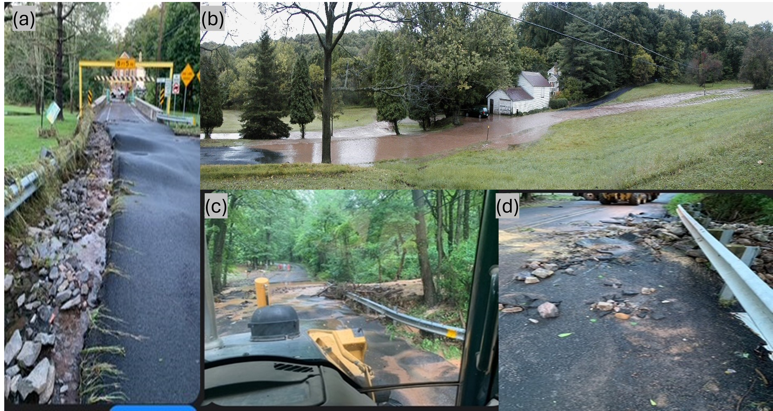
(a) Damage on Bridge Street, which has occurred two times in the last five years; (b) Flooding on Parkland Road; (c, d): Flooding and some of the aftermath on Pleasant View Road
Springfield Township, Bucks County, PA, in updating its Comprehensive Plan, recognizes the impacts of increasing climate-related events on property owners and infrastructure. The Township seeks to develop a hydrological model in order to produce a future flood predictive data risk map to identify stormwater and flooding vulnerability, to assist in determining priority areas and risk potentials to prevent damage, maintain safety, and enhance the overall quality of life for all. Such an approach will reduce costly reactionary responses, minimize emergency situations for the community, and provide a more cost-effective approach to stormwater management.
Results
Project Summary
Springfield Township, Bucks County, PA, whilst updating its Comprehensive Plan, recognized the impacts of increasing stormwater and flood events on property owners and infrastructure. In this project, the Township sought to evaluate future flood risk based on current and future rainfall intensity and frequency to assist in determining priority areas to take mitigation measures to prevent damage, maintain safety, and enhance the overall quality of life for all.
The project scientist analyzed 34 years of local rain-gauge records (NOAA NCEI Springtown station) and found that the largest one-day storm events are now about a quarter larger than the federal rainfall figures (NOAA Atlas-14) that the Township’s stormwater ordinance references. A seven-model CMIP6 climate ensemble projected an additional “climate uplift” of roughly 10% by the second half of the century, producing a forward-looking “design storm” planning target of about 11 inches in one day, compared with the roughly 8 inches currently assumed.
A Springfield-specific flood susceptibility map was produced from six public spatial layers, height above nearest drainage, soil type, distance to streams, impervious surfaces, slope, and surface-water occurrence. Overlain with FEMA flood data, it was used to rank sensitive receptors, including flood-prone roads, bridges (among them a historic covered bridge), buildings, the school, the emergency-operations center, villages, and an emergency drinking-water well. The analysis identified the three most vulnerable road crossings and flagged additional at-risk areas, including roughly 1,470 buildings in high-risk bands that sit outside the mapped FEMA floodplain.
Project Outputs
- Public flood dashboard (primary deliverable): An interactive, Springfield-specific flood dashboard presenting the susceptibility map, findings, methods, and references, was built. It functions as the team’s public summary and is designed so a follow-on engineering study or grant application can rebuild on every number without redoing the analysis. The StoryMap can be found here: https://storymaps.arcgis.com/stories/8aaad8738b4c46029ed1b14247078bf8
- Updated design-storm rainfall analysis: A 34-year gauge analysis combined with CMIP6 climate uplift, producing an ~11-inch one-day planning target versus the ~8-inch federal basis the ordinances currently cite.
- 10 m flood susceptibility raster (GeoTIFF): Ready for use in QGIS or ArcGIS.
- Building-exposure analysis: ~1,472 buildings in the High/Very-High susceptibility bands, broken down by building type and FEMA zone; most fall outside the mapped FEMA floodplain.
- Priority road-crossing ranking: Bridge St & Route 212, North Mine Rd, and Hickon Rd identified as the top three of six Act 167 flood-concern road sites.
- Sensitive-receptor ranking: Roads, bridges (including Knecht’s Covered Bridge, built 1873), the elementary school, the municipal building/emergency-operations center, village centers, and the Springtown drinking-water well.
- Well-generator siting memo: A preliminary, terrain-based recommended pad height for the emergency generator at the Springtown well.
- Supporting data and code: Per-point CSVs of every sampled metric and the analysis scripts (Python and Google Earth Engine).
- Policy recommendation: The new design storm data will be used to inform an update of the Township’s stormwater ordinances which will be under review following the final recommendations from the Bucks County Act 167 update.
Community Impact
The project will assist the Township in revising the design requirements for stormwater management systems in line with current and future predicted rainfall and prioritize stormwater and flood mitigation measures, both of which will lead to the better protection of residential properties and critical infrastructure, such as roads, bridges and schools. In the near term, it flags the three highest-priority road crossings and identifies roughly 1,470 buildings in high-risk bands, most outside the mapped FEMA floodplain, that a regulatory map alone would miss. Over the longer term, updating the design storm and directing the next round of stormwater spending toward the highest-risk locations should lead to better protection of residential properties and critical infrastructure such as roads, bridges, the school, and the emergency water supply. For context on the stakes, Hurricane Ida (2021) alone caused roughly $90,000 in township-wide damage.
Acknowledgements
- Wren Raming
- Lehigh University
- Bucks County Planning Commission
- Cooks Creek Watershed Association
Future Plans
- The results from this project and the Cooks Creek Watershed Conservation Plan Update will be assessed together to paint a fuller picture of the effects of stormwater and flood risks in the Township. Planning for measures to mitigate the effects will be informed by both projects. The Township will work with Cooks Creek Watershed Association and Durham Township to produce an implementation plan.
- The new design storm data will be used to inform an update of the Township’s stormwater ordinances which will be under review following the final recommendations from the Bucks County Act 167 update.
Other ideas under consideration include:
- The flood susceptibility map could be cross checked with data from First Street and ArcGIS Flood Impact Analysis solution
- The flood susceptibility map could be used to inform flood emergency management plans
- A field measurement at the Springtown well-yard (creek surface, plus Ida 2021 and Irene 2011 high-water marks) to sharpen the generator pad-height recommendation into a single engineering value.
Description
About the Community
The community leaders involved in the project are part of Springfield Township’s municipal government in Bucks County, Pennsylvania. Their primary goal is to address the challenges posed by climate change, specifically increasing flooding and stormwater management issues, through collaboration with Thriving Earth Exchange. Springfield Township, Bucks County, PA, is a predominantly rural residential community with significant agricultural and natural resource areas. that incorporates the majority of the Cooks Creek Watershed (24 of 30 square miles), an Exceptional Value Cold Water Fishery, and the only source of wild and native brown trout in SE PA. Just over 5,000 residents reside in our 30.8 square mile pie-shaped township, adjoining 8 other municipalities in three counties. With nearly 100 miles of roads, significant limestone karst, and the headwaters of multiple Delaware River tributaries, stormwater is a very significant concern here.
The township has recently updated its Comprehensive Plan, which emphasizes the urgent need to prepare for environmental changes and enhance community resilience. Since 2015, Springfield Township has had stormwater and flooding ordinances in place based on the existing federal floodplain data. However, the historically based floodplain data are inadequate for future planning to develop a climate-resilient township.
- Pennsylvania Climate Impacts Assessment 2021 Report
- 2024 Springfield Township Comprehensive Plan Report
- Zillow’s comprehensive climate risk data on all for-sale listings across the U.S
- Bucks County Act 167 Stormwater Plan Update (in progress and similar to this project)
- Community Remarks (mapping tool for communities to identify problem areas)
About the Project
Springfield Township in Bucks County has experienced recurring stormwater floods of increasing frequency, but thankfully, they have remained localized and limited in area. However, neighboring communities have faced significant impacts from these floods, prompting the Township to take proactive measures to mitigate future risks. The last major township-wide event was caused by Hurricane Ida in September 2021, resulting in approximately $90,000 in damages. The most recent significant rainstorm occurred in July 2023, and caused further infrastructure damage, but was concentrated in less populated areas. During this event, certain areas of Springfield received more than 6 inches of rain in under 8 hours. Bucks County’s terrain, with floodplains along streams and in valleys, makes it prone to flooding. The region’s low-rolling hills accumulate rainfall or snowmelt, which drains into streams and rivers, leading to the inundation of stream banks and adjacent floodplains. Climate change is exacerbating the risk of localized flooding, as evidenced by the closure of PA Route 309 due to flash flooding in 2019. Hurricanes and extreme winter storms also cause property damage, dangerous road conditions, and utility interruptions.
To address this growing threat, the township requires an updated, forward-looking flood risk map to identify vulnerable areas and prioritize mitigation efforts. The project results will protect residential properties and critical infrastructure, such as communication hubs and emergency centers. Additionally, community leaders are considering the potential of managing stormwater by increasing natural infiltration rates through reforestation and regenerative agriculture. The future flood predictive data and flood risk map will guide updates to ordinances and building codes, provide an assessment of vulnerable existing building stock, and new data for emergency management planning while ensuring that future development occurs in safe and sustainable areas. Furthermore, the community needs a comprehensive prediction model to accurately forecast the possible extent of future flood events, effective mitigation measures to reduce flood risks, and updated floodplain ordinances to ensure that goal.
Upon completion, the community will benefit from a more robust and adaptive infrastructure capable of handling extreme weather events and reduced flood risk. Additionally, the comprehensive stormwater management plan will enhance the township’s long-term resilience by fostering sustainable land-use practices, protecting ecosystems, and increasing public awareness of flood preparedness measures. The map will improve understanding of flood risk and vulnerable areas, enabling targeted approaches to ensure stronger, more durable infrastructure. Moreover, the map will facilitate the pursuit of funding for flood mitigation projects by providing evidence-based support for grant applications. Ultimately, this project will serve as a model for other municipalities facing similar challenges, demonstrating the importance of collaborative, forward-thinking approaches to climate resilience.
Timeline and Milestones

Project Team
Community Leaders

James (Jim) P. Hopkins, PE serving as a Township Supervisor, is a retired professional engineer with advanced degrees in civil engineering and management. His fifty years of engineering experience includes significant municipal and environmental projects. Locally, he has almost forty years of Township service in a variety of roles, including elected official, planning commission, open space, EAC, and liaison to Police, Parks & Land Preservation, Historic, and upper Bucks Chamber of Commerce. Regionally, he has served on the Delaware Valley Regional Planning Commission and Bucks County Association of Township Officials.

Bobb Carson is Professor Emeritus of Earth and Environmental Sciences at Lehigh University, with expertise in marine geology, sedimentation, tectonics, applied statistics, and paleoclimatology. He has served on the Springfield Township Planning Commission for nearly 50 years.

Rich Pursell serves as the Township Manager/Director of Public Works for Springfield Township. He holds a Bachelor of Science from Delaware Valley College and has 25+ years of experience in municipal government with a strong background in road infrastructure and finances. Additionally, he served as an elected official with a local municipality. He joined Springfield Township in 2019 and was appointed as the Township Manager in 2022. In this role, he is responsible for the daily operations of the Township.

Lorna Yearwood is a Township Supervisor for Springfield Township. She holds an MSc in Environmental Technology and worked as an environmental consultant for almost twenty years. She now owns and operates a small farming business in Springtown and has worked as an educator on organic gardening techniques at the local community college and school She has founded and been involved with various environmental non-profits over the years. She most recently served on the Springfield Township Environmental Advisory Council for 10 years.
Community Scientist

Kshitij Dahal is a PhD candidate at Arizona State University in the School of Sustainable Engineering and the Built Environment, specializing in hydrology and water resources. His research focuses on data-driven hydrology, geospatial decision support systems, and the integration of Earth observation, in-situ data, and machine learning for sustainable development. Growing up in Nepal, where he witnessed the impacts of floods and landslides, shaped his commitment to applying science to reduce community risk. He is an AGU Community Science Fellow (May 2024 cohort), a HydroLearn Fellow (2024), and an Outstanding Reviewer for Earth’s Future (2024).
Community Science Fellow

Sushree Sangita Dash is a doctoral candidate at McGill University. Her areas of interest are remote sensing, atmospheric modeling techniques, greenhouse gas emissions, climate change and hydrology. Beyond her academic pursuits, she is passionate about community engagement and has been actively involved in outreach initiatives to raise awareness about climate change and sustainable environment.
Collaborating Organizations
Nurture Nature Center

The Nurture Nature Center is a non-profit located in Easton, PA, that supports building community resiliency to environmental risk by leveraging the power of informal science education, art-centered approaches to learning, and community dialogue and networking. Started in response to flooding in Easton, NNC has over a decade of work related to flood outreach, education, and social science research. NNC is currently an AGU TEX Community Science Hub.
Cooks Creek Watershed Association

Cooks Creek Watershed Association was formed in 1974 with a mission to protect, preserve and improve the quality of water, land and life in the Cooks Creek Watershed. The CCWA is currently involved in regional planning efforts that will ensure the long-term protection of the creek.
Bucks County Planning Commission

The Bucks County Planning Commission (BCPC) assists the County Commissioners and all 54 constituent municipalities with the introduction, establishment, and administration of sound land use practices and policies, including stormwater management, that serve to protect the health, safety, and welfare of all County residents, equally, without prejudice, and in accordance with the Pennsylvania Municipalities Planning Code.
Status:
Complete,
Location:
Springfield Township,
Managing Organizations:
Nurture Nature Center,
Thriving Earth Exchange,
Project Categories:
Climate Resilience,
Flooding,
Storm Management,
Project Tags:
No tags