
Engaging community members in terrestrial invasive species management through data collection and mapping
Vilas County, Wisconsin, United States
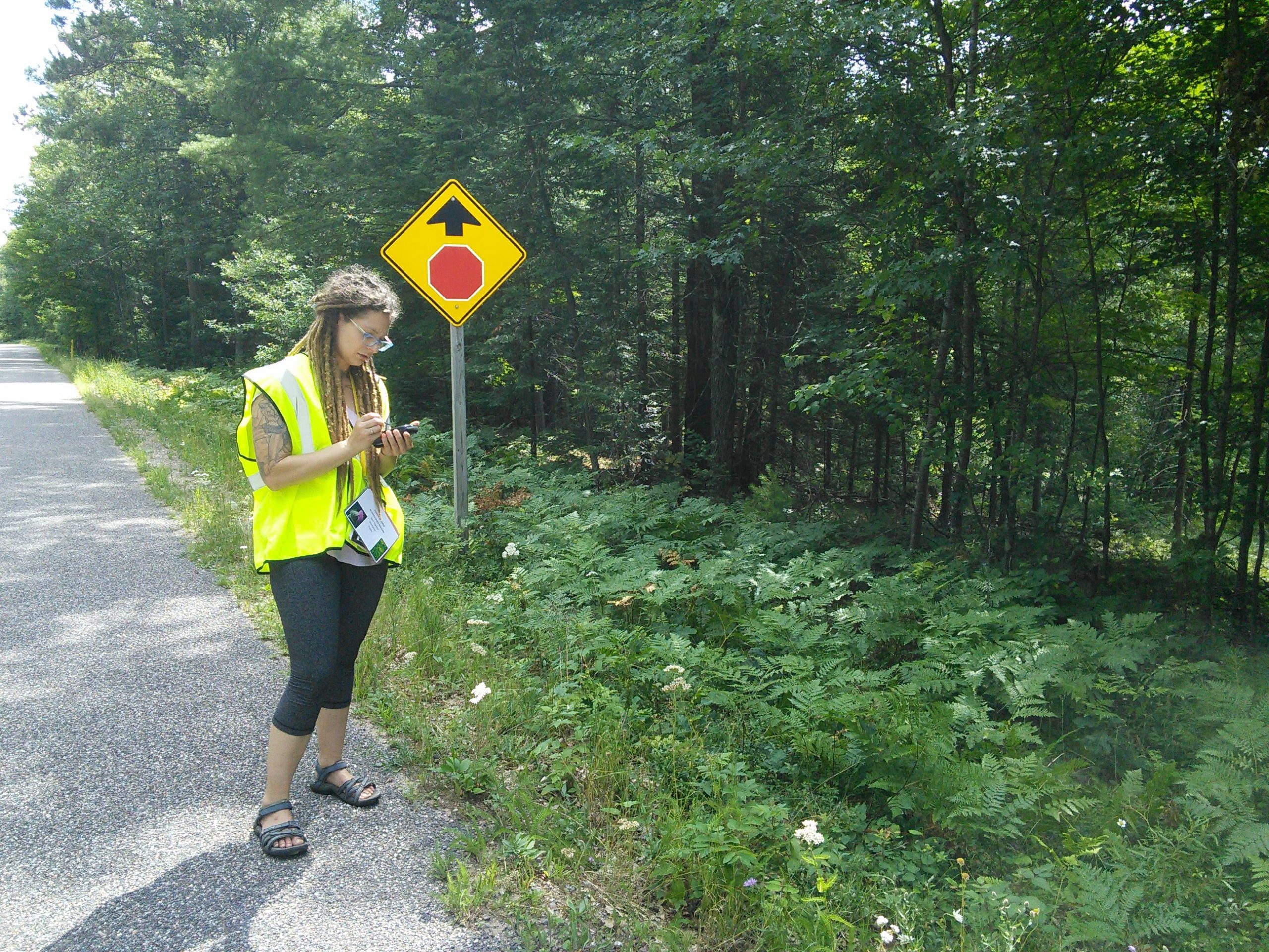
WHIP volunteer, Brittany Servent, conducting a roadside survey of invasive plants in Northern Wisconsin
The first step in this multi-faceted project is to host a community training and data collection event to teach volunteers how to recognize invasive plant species. The data collected by the community will then be combined with existing data to create visualizations to be shared with volunteers, land managers, and other invasive species management groups.
Description
The Community and the Challenge
The community is a coalition of Northwoods Cooperative Invasive Species Management Area groups (CISMAs), each operating in discrete counties in northern WI and the Upper Peninsula of Michigan. The Wisconsin Headwaters Invasives Partnership (WHIP), the Timberland Invasives Partnership (TIP), and the Wild Rivers Invasive Species Coalition (WRISC) have come together to collaborate on this project. Their common partner, the Lumberjack RC&D Council, is also a collaborator.
CISMAs are local organizations that bring together land-owners and land managers, often partnering with federal, state, local, and tribal government agencies, to coordinate action and share expertise and resources to manage invasive species. Their goal is to identify hotspots of invasive plant species and work with the landowners to manage these areas to avoid further spread. They also participate in outreach to educate the public and increase awareness of invasive plant species.
The three CISMAs involved in this project have been operating for many years in the region but have often felt that their efforts have lacked the scientific expertise to use the data that they collect to create useful maps and eye-catching and interactive visualizations. They believe that these visualizations would help to further motivate volunteers and land managers. The hope is that, through involvement with the Thriving Earth Exchange and the National Ecological Observatory Network, they are able to connect with a scientist who can work with them to further these goals.
The Project
The first phase of the project will involve planning and executing at least one community outreach and data collection event. Locally invasive plant species will be selected as the focus and an expert from the Wisconsin First Detector Network will be brought in to train local volunteers on the identification of the selected plants. After training, the volunteers will be deployed into the field to collect presence and absence data on the species in question. This outreach event will accomplish several goals. Firstly, it will provide training to local community members to aid in the identification and removal of these plant species on their own properties; secondly, it will generate interest in general invasive species management within the volunteer group; and finally, it will provide valuable data for the CISMAs to use during the second phase of the project.
After the data collection events have completed, the information gathered will be combined with existing data held by the CISMAs and possibly augmented with data collected by the National Ecological Observatory Network (NEON). A scientist with expertise in invasive species data and GIS mapping will work with the community to collate the information into useful and interesting visuals and possibly train the CISMA leaders on the use of GIS for mapping purposes. The goal of this phase will be to create outputs that can be shared with local landowners, property managers, or local governments to increase buy-in regarding the importance of invasive species management, to further motivate volunteers by providing visuals of how eradication efforts are affecting plant communities over time, and to introduce the CISMA leaders to the use of GIS in hopes that they will be able to continue using it into the future.
Timeline and Milestones
The project is expected to be complete in approximately 12-14 months after its conception in March 2021. The first outreach event will be scheduled in mid-July with a possible second in the fall. Phase two of the project will likely occur over the winter of 2021-2022 with final outputs by March-April 2022.
Project Team
Community Leads
As a Canadian transplant, Rosie Page became the WHIP Coordinator in May of 2014. Throughout our three counties, Rosie handles invasive species outreach and education, carries out our control work, and is responsible for all grant applications. Rosie holds Bachelors and Masters degrees in Biology from the University of Windsor, Ontario, Canada, and she became interested in invasive species while watching species like Phragmites, Purple Loosestrife, and Emerald Ash Borer invading her favorite parks. After several years as an ecologist with the Ministry of Natural Resources in Thunder Bay, she expanded her interests into Wisconsin in 2012 to work on roadside invasive plants. Rosie enjoys looking for creative grant sources, and helping new groups learn about invasive species in the Northwoods.

Lindsay Peterson holds a BS in Environmental Geoscience with an emphasis in Water Science from Northland College. She has been with WRISC since 2015 and has been the Coordinator of WRISC since 2017. Originally from Foster City, Lindsay loves being able to work with the local community she grew up in. In her free time, Lindsay enjoys backpacking, gardening, & adventuring with her family & two dogs.
 Alix Bjorklund has coordinated Timberland Invasives Partnership since May of 2018. She graduated from the University of Wisconsin-Green Bay with a Bachelor of Science in biology and a minor in environmental science. She is currently pursuing a Master of Science in environmental policy and administration from her alma mater while running her CISMA, and is focused on right of way invasive species controls as well as specific projects like a county-wide Japanese knotweed removal in Shawano county.
Community Scientist
 Anne Pearce coordinates the Wisconsin First Detector Network, a community science network that empowers people to take action against invasive species through education and volunteer opportunities. She is also a member of Invasive Plants Association of Wisconsin’s board of directors and leads restoration volunteer work parties at the UW-Madison Arboretum.
Community Science Fellow
 Ashley Spink works as a Senior Field Ecologist for the National Ecological Observatory Network (NEON), operated by Battelle. She works in Northern Wisconsin and the Upper Peninsula of Michigan leading teams in the field to collect ecological data. Ashley’s background is in wildlife ecology with a Masters degree from the University of WI-Green Bay in Environmental Science & Policy and a Bachelors degree from the University of WI-Stevens Point in Wildlife Ecology & Management. In her free time, she loves spending time with her husband and two children, hiking or snowshoeing in the forest, and riding her horses. Ashley is passionate about science communication at the community level and making science accessible to everyone.
Collaborating Organizations
![]() Wisconsin First Detector Network (WIFDN) is a statewide community science network that empowers people to take action on invasive species through education and volunteer opportunities across Wisconsin. Since 2014, WIFDN volunteers have reported over 20,500 invasive species infestations and contributed over 18,000 hours to invasive species monitoring, management, and outreach.
Wisconsin First Detector Network (WIFDN) is a statewide community science network that empowers people to take action on invasive species through education and volunteer opportunities across Wisconsin. Since 2014, WIFDN volunteers have reported over 20,500 invasive species infestations and contributed over 18,000 hours to invasive species monitoring, management, and outreach.
 The Wisconsin Headwaters Invasives Partnership (WHIP) is a 16-partner cooperative group serving Oneida, Vilas, and Lincoln counties in northeastern Wisconsin. Since 2010, WHIP has worked with local and regional government agencies, environmental schools, and private landowners to accomplish its mission of combating invasive species on the landscape. WHIP uses a variety of grant funding to deliver community outreach programming, survey for terrestrial invasive species, and carry out control and management projects. WHIP’s involvement will include planning and implementation of training events, helping to recruit participants, and using local knowledge to determine appropriate invasive species field sites.
 The Wild Rivers Invasive Species Coalition (WRISC), as a multi-partner organization representing five counties in two states, is dedicated to the management of invasive species on our lands and waters through cooperation, education, prevention, and control.
 The Timberland Invasives Partnership (TIP) is a partnership between federal, tribal, state, and local government organizations that serves to symbolize & solidify their commitment to work together across jurisdictional boundaries to eliminate invasive species. Our Cooperative Invasive Species Management Area (CISMA) serves the lands and waters within the Langlade, Menominee Oconto, & Shawano county borders.
 The National Science Foundation’s National Ecological Observatory Network (NEON) is a continental-scale observation facility operated by Battelle and designed to collect long-term open access ecological data to better understand how U.S. ecosystems are changing.
Status:
Complete,
Location:
United States,
Vilas County,
Wisconsin,
Managing Organizations:
National Ecological Observatory Network (NEON),
Project Categories:
Conservation,
Natural Resources,
Project Tags:
No tags