
After a devastating earthquake abroad, a university community asks ‘How can we help?’
Building on a collaboration in place before the disaster, students, faculty and alumni map landslide risks to aid Nepal response and recovery
By Nancy D. Lamontagne
After the devastating 7.8-magnitude earthquake that struck Nepal in April 2015, students and faculty from the Yale University School of Forestry and Environmental Studies and the Yale Himalaya Initiative wanted to find a way to help with recovery.
“There were many students here, especially ones in the Nepali student association, who were very keen on raising funds,” said Alark Saxena, Ph.D, associate research scientist in the Yale University School of Forestry and Environmental Studies and director of the Yale Himalaya Initiative. “Although they did well, it is always challenging to raise funds in the university where students need funds to sustain themselves. In my opinion, the best way for universities to participate in recovery is provide their own intellectual resources rather than financial resources.”
Luckily, in this case there was already a framework in place to connect Yale’s extensive intellectual resources with Nepal’s response and recovery needs. The Yale Himalaya Initiative, active in Nepal for several years before the quake, is an interdisciplinary platform that brings together researchers and students working in the region to understand the Himalaya landscape as a transregional whole, without the restrictions of political boundaries. “We are very interested in making sure that our work is clearly relevant to the region and not just work done for the sake of research,” said Saxena.
After the earthquake, members of the initiative immediately began reaching out to their contacts in Nepal to find out what kind of analyses might be helpful in recovery, but in the chaos of the disaster’s aftermath, it was hard to get answers. So Saxena booked a flight and journeyed to Nepal in person to find out how the Yale Himalaya Initiative could help.
During his trip, Saxena visited the International Centre for Integrated Mountain Development (ICIMOD), an organization of eight member nations headquartered in Kathmandu, Nepal. While there, he met Deo Raj, a GIS specialist who was overwhelmed with numerous requests from the government while also trying to train a team of volunteers to map landslides triggered after the earthquake. Raj was excited when Saxena asked if the Yale Himalaya Institute could help with the landslide analysis.
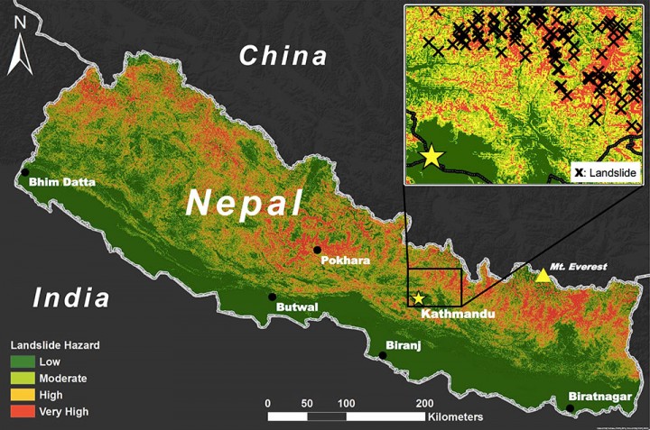
Landslides are a major concern in mountainous regions like the Himalaya. After a quake, water from monsoonal rainfall can loosen the soil and trigger massive landslides. In the weeks after the 2015 earthquake, tens of thousands of landslides occurred across the Himalayan region, some of which buried whole villages.
Building the Yale Himalaya Hazard team
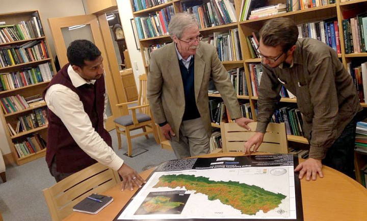
Upon his return to Yale, Saxena identified a team of students and recent alumni with GIS skills and asked the School of Forestry and Environmental Studies Office of Development and Alumni Services to identify alumni who might be interested in helping with the project. The Office identified Forrest Berkley, an alumnus who agreed to financially support the project.
The Yale Himalaya Hazard team consisted of alumni Ross Bernet, Angel Herslet, and David J.X. Gonzalez as well as undergraduate Olivia Walker and Jonathan Reuning-Scherer, a senior lecturer in statistics at F&ES who provided technical support. Under Saxena’s leadership, the team decided to incorporate several types of information to create a map that would not only show where landslides had already occurred, but also indicate the level of risk for landslides for the entire country.
The researchers first mapped areas with a high probability of seismic activity as well as areas where the landscape has steep slopes and is thus more susceptible to landslides. This was overlaid with areas that experience high monsoon activity, because rain can weaken the soil strata, creating favorable conditions for landslides. (Climate change is also exacerbating monsoon patterns, which can increase landslide risk for areas with high amounts of monsoon rainfall). Finally, they added the human component to the map by indicating densely populated areas with a significant risk for landslides.
“We used existing places where there were clear indications of landslides to train a computer model and then spread this information across Nepal,” said Saxena. “Our model uses events that have happened in the past to create a probability distribution of events that could happen in the future. In this way, it offers a snapshot of events that have happened in recent time, but the concept can be used again to create updated maps.”
By identifying high-risk areas, the map provides the government and people of Nepal information on areas where structures should not be constructed, or if construction is unavoidable, building codes should be more rigorous and enforced strictly.
In addition to providing the map to ICIMOD, the Yale team has also shared it with many voluntary organizations including a community living in the region of Rasuwa. “Rasuwa was devastated by the earthquake and did not get enough recognition,” said Saxena. “Volunteers working in that region were interested in using the map for their own decision making.”
Reducing future risk
Saxena says that the project demonstrated that using university resources to contribute to analysis can directly help local communities after a disaster and also help reduce future risk. “In this case we used university resources to provide information that allows people to understand the risk associated with their landscapes,” he said. “Bringing our knowledge to the problem was the best way to help after the earthquake.”
Saxena adds that when disasters happen it is important to take time to think through the problems and possible solutions. “It is unfair to ask the local communities to describe what they need right away,” he said. “Once they are hit by a calamity, their life is upside down. We spent a lot of time figuring out what was needed, and it ended up requiring us to be present on the ground to truly understand.”
Saxena also points out that collaboration was key to successfully meeting the need identified by ICIMOD. “It was a collaborative effort involving ICIMOD, the Himalaya Initiative, the School of Forestry and Environmental Studies which identified recent alumni who willingly stepped up to the challenge and the Development Office that reached out to its donors to support the effort.”
The project has helped strengthen the working relationship between the Yale Himalaya Initiative and ICIMOD, which Saxena says he hopes will lead to new collaborative projects to benefit the region.
Nancy D. Lamontagne is a freelance science communicator and a contributing writer for Creative Science Writing and the Thriving Earth Exchange.
Related articles:
Yale Himalaya Initiative, F&ES Map Risks in Post-Earthquake Nepal
Yale Responds to Nepal Earthquake: ‘Our Commitment Will Continue’