
A NOAA grant prioritizes coastal resiliency in the face of an uncertain future
By Kathleen Pierce
Cape Cod is a fragile coastal community, surrounded on three sides by water and home to extensive estuaries, salt marshes, and more than 400 miles of coastline and beaches. Here, the lives and livelihoods of 220,000 year-round residents, and the 400,000-plus summer visitors, are tied to the water. Increasing storm severity, widespread flooding, water contamination, and destruction to homes and businesses could spell disaster for the area: Coastal resiliency is essential if Cape Cod wants to survive the coastal hazards climate change is expected to bring in the coming decades.
“Our environment is our economy,” said Kristy Senatori, deputy director of the Cape Cod Commission, a regional planning agency that protects the quality of life on Cape Cod. “We have to face the reality that we are a vulnerable community, and building resiliency will help us bounce back from disaster, socially, environmentally, and economically.”
But in order for the public and decision makers to truly embrace and embody coastal resiliency, people first have to understand what coastal threats loom, what their consequences would be, and how they can be mitigated. This understanding is the ultimate goal of a new project, led by the Cape Cod Commission and several partner agencies, that was recently awarded a highly selective, three-year, $780,000 Regional Coastal Resilience Grant from the National Oceanic and Atmospheric Administration (NOAA).
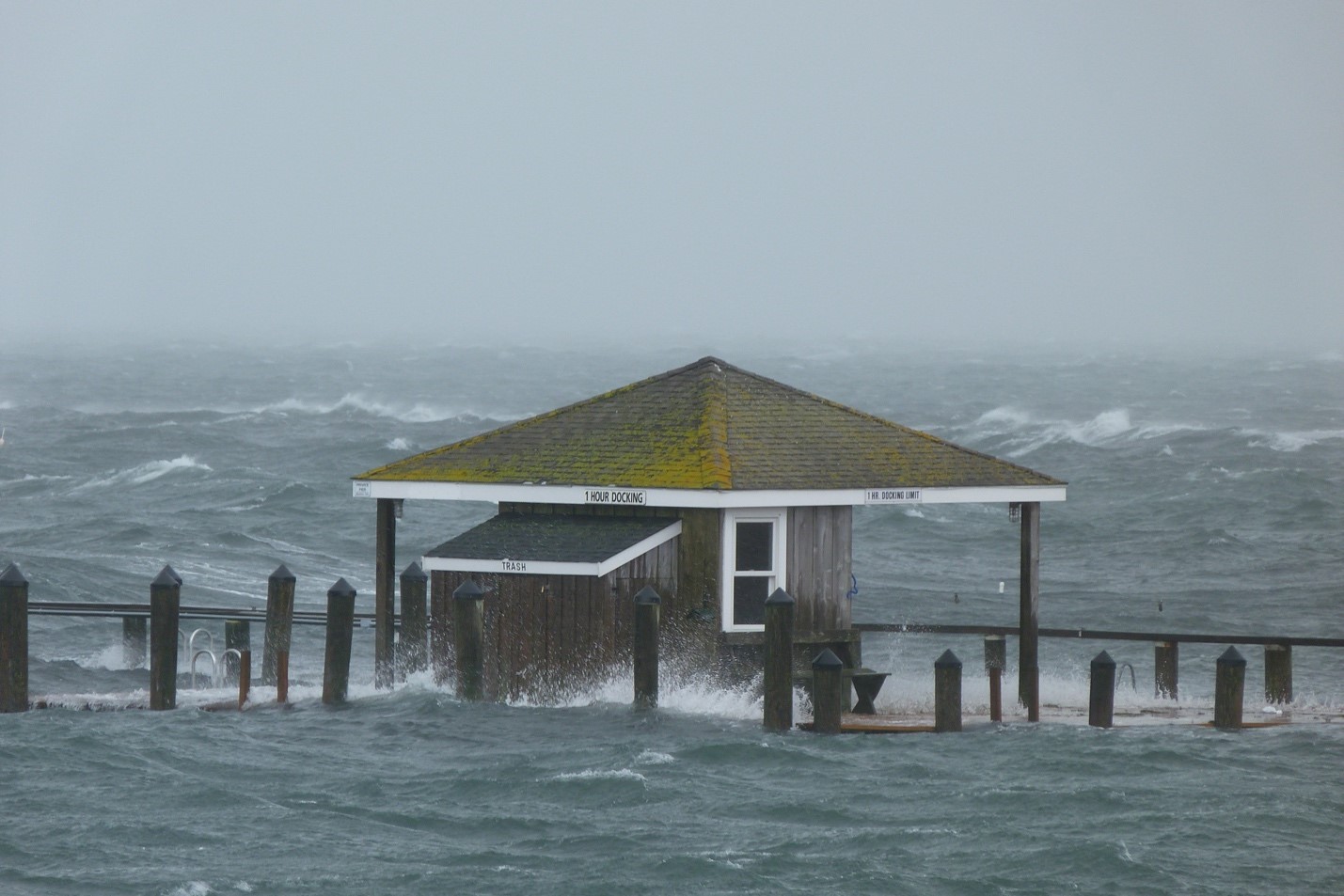
The Hyannisport Pier during Hurricane Sandy, 2012
Recruiting a team with the right expertise—and a passion for progress
The effort is a large-scale collaboration involving a variety of science-, community-, and policy-oriented organizations in addition to the Cape Cod Commission. The Association to Preserve Cape Cod, an environmental nonprofit, and the Center for Coastal Studies, which is dedicated to preserving coastal ecosystems, will research and analyze local climate data such as sea level rise, flooding, and shoreline change, as well as the costs of different adaptation strategies. The Waquoit Bay National Estuarine Research Reserve (WBNERR) will facilitate the public outreach and education component. The Massachusetts Coastal Zone Management, a policy and planning agency, and the Cape Cod Cooperative Extension are also supporting the project.
The final partner is the Town of Barnstable, where the team plans to test their end product: a decision-support tool that synthesizes and simplifies complex climate, environmental, and economic data in order to make it easier for citizens and public officials to determine the best resiliency strategies for their community. This tool will also make users aware of just how disastrous the consequences of doing nothing could be.
Barnstable is the largest community on Cape Cod, and its residents have demonstrated a strong commitment to mitigating and adapting to climate change. In 2013, the Town (along with WBNERR) partnered with the Massachusetts Institute of Technology and the University of New Hampshire’s Consensus Building Institute on the New England Climate Adaptation Project (NECAP), which used role-playing simulations to educate communities about their vulnerabilities to climate change. Barnstable also recently concluded an EPA-sponsored Best Management Practice plan for stormwater management, which exceeds the National Flood Insurance Program’s minimum requirements for floodplain management, and the town maintains an updated Hazard Mitigation Plan to stay abreast of threats as they evolve.
“We were thrilled when they asked us to be partners in this project,” said Elizabeth Jenkins, regulatory design planner for the Town of Barnstable. “All towns are resource-constrained, and this allows us to increase our capacity to do resilience planning.”
Planning a comprehensive project to bring climate realities to the forefront
This partnership is embarking on a three-year, four-phase journey to collect, analyze, and translate complex climate data into more-easily digested information that enables stakeholders—both private citizens and public officials—to anticipate hazards and costs of different scenarios and prepare resilience strategies ahead of time.
The first phase is to collect climate data and predictions relevant to Cape Cod while also building a database of potential adaptation strategies. In the second phase, organizers will solicit public opinion on the costs, benefits, and drawbacks of the different resilience strategies. The team will also engage the region’s residents via surveys and focus groups to determine how the community values coastal resiliency and what consensus can be reached on strategies, costs, and tradeoffs. In the project’s third phase, the team will develop their decision-support tool, which will be pilot tested in Barnstable during the fourth and final phase.
It’s impossible to say exactly what the decision-making tool will look like when completed, but the team envisions a GIS-based map of Cape Cod’s coastal assets with several categories of data layered on top, where users can impose different coastal hazard scenarios at varying levels of scale. The idea is to simplify complex technical data, enable a cost-benefit analysis of different resilience strategies, and estimate public and private losses at local or regional scales. The tool’s goal is to show the public how resource allocation can address both coastal hazards and community needs.
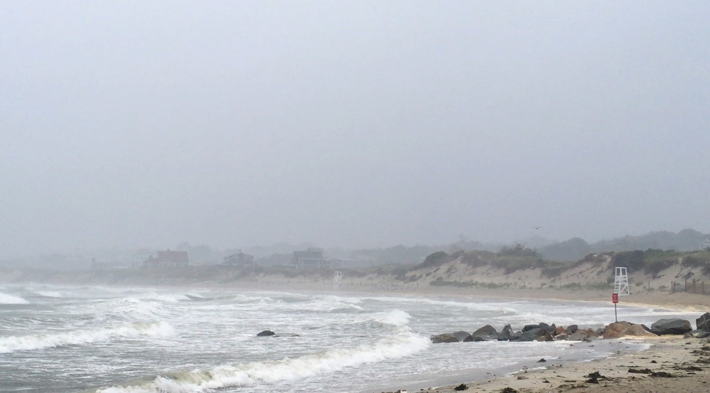
Corporation Beach storm surge from Tropical Storm Hermine, 2016
Capitalizing on past lessons learned
This isn’t the first time that the Cape Cod Commission has asked for the public’s input when tackling a thorny environmental issue. The new Resilience Grant project can benefit from lessons learned—about community engagement, collaboration, and using science to inform decision making—during a recent effort to update the Section 208 Water Quality Management Plan, which addresses water degradation due to excess nitrogen.
“Scientists and engineers often think they have the answer to the problem,” Senatori said. “But we really tried from day one to not ‘solve the problem,’ but to put all of the information on the table. A lot of what we learned there, we are translating into this new process.”
The Town of Barnstable had lessons to share as well. For NECAP, a role-playing game where residents and officials stepped into one another’s shoes was particularly rewarding. “It sounds a little ‘out there,’” said Jenkins, “but as people went through the process, they changed their stance almost 180 degrees. It was a great way to really immerse everyone in thinking about climate change impacts from a policy perspective.”
Ensuring resilience
The Cape Cod community has been strongly supportive of the NOAA grant. “Everyone’s been saying for a long time that our environment is our economy, and we need to make sure we preserve it,” Senatori said. “This is one way we can ensure that we are a resilient community.”
Cape Cod’s most destructive storm to date was Hurricane Bob, in 1991. But local leaders are not waiting until another storm comes along—their hope is that this NOAA grant will help them build coastal resiliency now, before the next crisis. It could also encourage other communities to do the same: The decision-support tool will be adaptable to other coastal communities, who can then use it to make decisions in their own best interests.
Kathleen Pierce is a contributing writer for Creative Science Writing and the Thriving Earth Exchange.


