
Modelización de los efectos de la I-10 en la salud ambiental para implicar a residentes y responsables políticos
New Orleans, Louisiana, United States
Resultados
The Team
Amy Stelly, Claiborne Ave. Alliance, [email protected]
Emily Gaddis, Claiborne Ave. Alliance
Adrienne Katner, Louisiana State University School of Public Health, [email protected]
Kari Brisolara, Louisiana State University School of Public Health
Resultados
The focus of the Claiborne Ave., New Orleans project was to characterize environmental hazards, exposures, potential health implications and traffic-associated health outcomes for the communities living around Interstate I-10 (also referred to as the I-10 corridor).
In their final report, linked below, LSU’s Public Health team found that residents living in the I-10 corridor are in the top 95th to 100th percentile in the state in terms of traffic proximity. In the Summary of Results on pages 6-8, the team outlines the following:
- Environmental issues of greatest potential concern, including air contaminants, legacy soil lead and traffic-related noise pollution.
- Exposures to pollutants to children, residents, homeless, and workers including inhalation of fine particulate emissions from I-10 road traffic; inhalation and ingestion of soil lead by children, and noise pollution.
- Adverse health impacts including respiratory diseases, cardiovascular disease, adverse birth and developmental outcomes, immune system diseases and cancer.
- Vulnerable populations including children, seniors, pregnant women, those with compromised immune systems, and homeless populations residing under I-10.
- Implications of land use policies pose an additional threat to health due to increased community use of the areas under I-10.
- Recommendations outlined via 6 different scenarios ranging from maintaining the status quo (i.e. no changes to the I-10 corridor) to complete removal of the I-10 interchange.
Métodos
To prioritize traffic-related environmental issues of concern in the I-10 Corridor area, scientific literature was reviewed to identify traffic-associated pollutants, exposure levels of concern (traffic volume, interstate proximity and air pollutant concentrations), and adverse health outcomes that are significantly related to interstate traffic and automobile emissions.
Multiple site visits were conducted to measure noise, air concentrations of particulate matter and to document potential exposure routes. Monitoring and emissions modeling data for the area from multiple third-party sources were requested and/or summarized. Hazard monitoring data were reviewed to identify those occurring at levels that exceed health-based standards; health outcome statistics for the community in zip codes adjacent to the site were also reviewed to identify areas with rates of adverse health outcomes occurring at rates exceeding state values. Land use recommendations were evaluated and discussed within the context of their potential implications on the prevailing environmental, exposure and health conditions.
 Estimates of interstate proximity were conducted using Google Earth distance measurement tool. Measurements were made in meters to enable comparison with proximities reported in the literature. Interstate traffic volume estimates were obtained from the LA Department of Transportation (LDOT). Air concentrations, either measured of modeled, were derived from either the US EPA or the LA Department of Environmental Quality (LDEQ) databases. These site-specific “exposure” measures were then compared to those measures in the literature that were found to be significantly associated with traffic-related health impacts, and available health-based standards. Health risks or hazard index estimates derived from federal studies of site-specific traffic-related emissions modeling were also evaluated to flag health conditions of potential concern.
To assess ambient particulate matter (PM) levels, the team conducted limited monitoring of particulate matter (PM) levels within the Claiborne Corridor- either directly under the overpass, across the street, and at some further distance to evaluate proximity impacts on PM levels. To conduct the particulate air monitoring assessment, a Dylos DC 1170 air quality monitor was used.
Available disease rate data for this area were obtained from various health surveillance databases and compared to the list of flagged priority traffic-related emissions and associated health outcomes. Site-specific disease rates which exceeded rates of the city, state or nation were identified as having a potential association with current traffic conditions.
Land use scenarios and their impacts on traffic were derived from the Livable Claiborne Corridor study (LCC). Impacts on all traffic and diesel-related traffic were considered as the driving factor in charactering the potential impact of each scenario on environmental and health conditions for the area (see Appendix C for reports reviewed). Recommendations to reduce contaminant exposures were derived from prevailing public health guidelines.
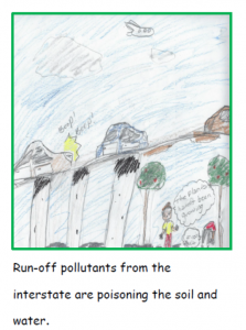 Towards the end of the project, Amy Stelly visited the 4th grade students at Phillis Wheatley Community School to conduct some environmental monitoring of the air and water. Together, with Thriving Earth Exchange partner, Laboratorio público, the students launched a weather balloon to collect some aerial photos of the corridor. The students were assigned to reflect on the day and note what they experienced and how they felt about the activities. Amy made sure to visit the classroom ahead of the field day to talk to the students about the history of the I-10 corridor. As a result of their interactions and field day launching a balloon, the students produced a children’s book where they wrote and illustrated their experiences.
Resultados del proyecto:
Katner A, LeCompte E, Stallard C, Wash I, Stelly, A, Gaddis, E, Brisolara K. Traffic-Related Pollutants and Human Health within the I-10 Claiborne Corridor, New Orleans, LA: Land Use Implications. Report presented to the Claiborne Avenue Alliance, the American Geophysical Union’s Thriving Earth Exchange Program and the New Orleans City Council. (April 2019). Louisiana State University School of Public Health, New Orleans, LA.
- REPORT APPENDICES
- Table Summarizing Literature Reviewed
- Outreach Brochures
- Review of Low-Cost Air Monitoring Equipment
- Summary of Recommendations and Resources for Residents
- Summary of Recommendations for Policy Makers
- Policy Brief
- SLIDE PRESENTATION: I-10 Preliminary Assessment
- MEETINGS
- Councilperson Kristen Palmer – August 27, 2019. Tried to give the group some strategies about talking to the Council about the issues in the I-10 corridor. Palmer’s concern is making sure there’s a balance in the discussion.
- Meeting Before the City Council’s Governmental Affairs Committee (Sept. 25th)
- Meetings with Senator Cassidy (not yet scheduled)
- CHILDREN’S BOOK: Wheatley Book -Thriving Earth Exchange
- Wheatley’s 4th grade class joined the partners in a day-long monitoring expedition to the site and wrote about their results and experiences in a book which the partners published
- “Field Study of the effects of I-10 Claiborne Corridor on the Treme neighborhood” by Kelly Davidson’s 4th grade class at Phyllis Wheatley Community School, May 2019.
- LESSON PLAN: A lesson plan was prepared by the teacher of the partnering school and will be completed for release soon. It is intended to introduce students to citizen science, air monitoring, and civic engagement
- Elementary School: EPA Curriculum_Elementary School_Lesson Plan booklet
- High School: EPA Curriculum_High School_Lesson Plan booklet
- NEWS MEDIA
- Claiborne Ave. Alliance Leads a Corridor Tour. LSU Health: New Orleans School of Public Health, October 24, 2018.
- Fourth graders launch weather balloon to photo-document traffic-related pollutants along Claiborne Corridor – WDSU News, May 13, 2019
- Claiborne Expressway, Through the Eyes of Fourth Graders. New Orleans Public Radio, May 16, 2019
Reflections
A partir de este proyecto, otros pueden aprender mejores formas de asociarse con Thriving Earth Exchange para sus propios fines. Por ejemplo,
El equipo observó que lo siguiente contribuyó al éxito del proyecto:
- Convening frequent meetings to discuss the progress of the project and input.
- Regular communication between all team members.
- Complete transparency around meetings, communications with local elected officials and community members.
- Support from LSU students allowed the team to study the environmental issues from multiple angles.
- Partnering with other community groups helped further their reach and access additional resources (partnerships with Public Lab and Phillis Wheatley Community School).
- Meeting via Zoom with Thriving Earth Exchange on a monthly basis kept the science team on a timeline and expectations in check. The science team first needed a baseline to characterize what was happening in the corridor, then look to scenarios.
Sin embargo, el equipo haría algunas cosas de forma diferente si tuviera la oportunidad de repetir el proyecto:
- Request data earlier in the process from government agencies.
A otros equipos que actualmente llevan a cabo proyectos de Intercambio para una Tierra Próspera y a los que prevén realizar un proyecto de Intercambio para una Tierra Próspera, el equipo les recomienda:
- Remain open to input by listening and designing projects for action.
- Get students and children involved on the project. This was helpful in attracting media attention to the project and helped engage a whole new generation of people.
- If you’re a community leader, you must keep up your stamina and allow people to work at their own pace (i.e. no forcing people to attend meetings, rather allowing them to participate when they can).
- Sometimes you must be firm to get the deliverables – be more discerning when choosing partners when you have deliverables to meet.
- When working with students, be sure to allow them to pursue what they are interested in and feel enthusiastic about investigating (this ensures better results).
- Share results and progress via a website: https://www.claiborneavenuealliance.com/about
Descripción
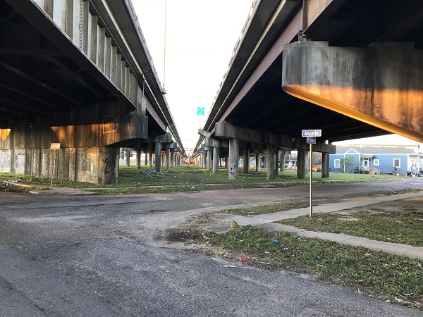
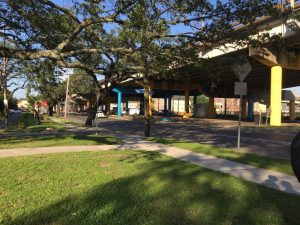
The Claiborne Corridor in New Orleans, Louisiana, is a network of neighborhoods surrounding Claiborne Avenue, a major thoroughfare running more than 9 miles through the city center. It extends from Jefferson Parish in the west to St. Bernard Parish in the east and encompasses a number of predominantly African American communities, including the nation’s oldest, Tremé. In the late 1960s, Interstate 10 was constructed above the central segment of Claiborne Avenue in and around Tremé. The impacts of I-10 on neighboring communities since that time have been far-reaching. The physical division of previously connected neighborhoods and the removal of businesses along what used to be a commercial artery have fragmented the community socially, culturally, and economically. Today, poverty and crime are disproportionately experienced by residents of the Claiborne Corridor, and reliable access to jobs, housing, and transportation remains a challenge.
Claiborne Avenue Alliance is a coalition of local residents and business owners whose aim is to “reclaim, restore, and rebuild” communities along the Claiborne Corridor that have been negatively impacted by the construction of I-10. The environmental and health impacts of I-10’s presence are a key concern that motivates their engagement with TEX. Air pollution from vehicle emissions is a particular concern, and residents near the interstate note that particulates visibly coat the walls of homes and businesses. Noise and light pollution associated with vehicle traffic compound potential health effects. Moreover, the removal and paving over of historic green spaces along the corridor have exacerbated the impacts of local flooding, with consequences for water quality, ease of local transportation, use of outdoor spaces, etc.
Despite efforts to raise residents’ concerns via position statements, media engagement, and discussions with local authorities, Claiborne Avenue Alliance feels that the community’s voice is not being fully heard by decision makers. They believe their voice would be amplified and residents empowered by a comprehensive, data-driven documentation of the environmental and health impacts of the I-10 corridor. While some such data already exist, these are spread across multiple sources, and the cumulative effects of multiple environmental stressors is not easily communicated. These concerns are set against the backdrop of the upcoming New Orleans Tricentennial and associated plans by local authorities to revitalize Claiborne Avenue, which present both challenges and opportunities.
Claiborne Avenue Alliance seeks support to mine, compile, and interpret existing data documenting the environmental impacts of the I-10 corridor on the health and well-being of local residents, and to communicate these impacts to relevant parties. They are especially interested in scenario modelling as a means of communicating the cumulative impacts of I-10 in its current state, as well as scenarios that model alternative, improved visions of the future of the Claiborne Corridor (e.g., with new environmental safeguards in place). In their own words, “We want to be able to effectively communicate our experience [of living with the I-10 corridor] and our vision [of what Claiborne could be].” This work would culminate in a community forum bringing together residents, decision makers, media, and other stakeholders. The aim of this forum is to engage all parties in a collective vision, supported by science, visualized via scenario modeling, and communicated in creative and digestible ways. Specifically, the groups hopes this work will:
- engage and empower residents through improved understanding/knowledge;
- strengthen the community’s voice and leverage with local decision makers; and
- focus their efforts to inform local policy decisions by identifying leverage points related to environmental and health outcomes.
Equipo del proyecto
Líderes comunitarios
Amy Stelly and Tamah Yisrael, represent the leadership of the Claiborne Ave. Alliance. Claiborne Ave. Alliance members, Emily Gaddis and Margaret Thomas, are also involved to provide their knowledge of local environmental issues and the local healthcare system.

Amy Stelly serves the New Orleans community as an advocate for the redevelopment of the Claiborne Corridor. She has advocated for water safety and water management, written about the value of public engagement, lectured on community garden design, and the history of open space in Treme.
Amy is an artist, designer, and planner. Her body of work includes architectural and urban design, along with abstract painting, drawing, mask-making, photography, mixed-media and three-dimensional construction. As a designer and planner, her scope of work includes building and open space design, historic restoration, downtown and neighborhood revitalization, environmental planning, municipal zoning, incentives, entitlements, site planning, streetscapes and gardens. She has also led collaborative projects and taught integrated arts to a variety of students including autistic, gifted, main-stream and incarcerated youth.

Tamah Yisrael is the Executive Director of Builders of the Highway Foundation, a national non-profit. Through her leadership the Foundation has successfully merged the Neo Jazz School of Music under its umbrella and developed the Tombar Life Center. Yisrael is a business owner and community advocate and dedicated to providing education and opportunity through music and the arts. Her previous professional experience includes hospitality business management, chief financial officer, controller, paralegal, and bookkeeper.

Emily K. Gaddis, M.A., is a social entrepreneur, educator, intercultural trainer, and eco artist. As a trained curriculum developer, she applies an interdisciplinary approach to environmental education with attention to empowering communities to reduce their exposure to chemicals of concern and inspire others to lead positive lives.
Her journey in sustainable business operations began in 2015, and within the first six months, she won seven of eight live business pitch contests, secured start up funding exclusively through grants, and completed business accelerator Cleantech Open. In 2016 she co-founded the first natural wine shop in Louisiana, Spirit Wine. By re-designing operations, Spirit Wine eliminated over 90% of its waste, switched to clean energy, and formed strategic partnerships to recycle all product packaging. Having tested the waters of operating a triple bottom line business, her main mission in life is to collaborate with business, community, and government to bring the circular economy to the South and create a strong network of green collar jobs.
Enlaces científicos

Dr. Adrienne Katner is an Assistant Professor at Louisiana State University-Health Science Center’s School of Public Health in the Environmental and Occupational Health Program. Prior to entering academia, Dr. Katner worked at the National Cancer Institute’s Occupational and Environmental Epidemiology Branch, where she conducted exposure assessments for a nationwide non-Hodgkin lymphoma study; and at the Louisiana Office of Public Health (LOPH), where she oversaw several statewide environmental health programs.
Dr. Katner’s research garnered national attention in the aftermath of Flint, Michigan, as her results and findings highlighted problems with drinking water regulations and prevailing guidelines to reduce exposure to lead from drinking water. She has used her research to propel policy changes and government action, including: a statewide policy change by LOPH to require water testing during home inspections of lead-poisoned children; a follow-up state investigation and confirmation of a significant lead in water crisis in the town of St. Joseph, LA, which resulted in a Public Health Emergency Proclamation, and state replacement of the town’s corroding drinking water infrastructure; and triggering an New Orleans Office of Inspector General report, which raised awareness of an “imminent risk” to residents from lead spikes in water after partial lead service line replacements.
Dr. Katner received a Bachelors in Molecular, Cellular and Developmental Biology from the University of California at Santa Cruz; a Masters in Soil, Water and Environmental Science from the University of Arizona; a Doctorate in Environmental Science and Engineering from the University of California at Los Angeles; and “Katrina Hero for Environmental Justice” and “Community Angel” awards from local non-profits for her work to increase awareness of lead in water hazards and cost-effective exposure prevention solutions.

Dr. Kari Fitzmorris Brisolara is an Associate Professor of Environmental and Occupational Health Sciences at the LSU Health Sciences Center, School of Public Health in New Orleans, Louisiana. She received her BS in Biology and Physics from Louisiana College, MSPH and Doctor of Science degrees in Environmental Health Sciences from Tulane University, School of Public Health and Tropical Medicine. After Tulane, she accepted a post-doctoral appointment with the United States Department of Agriculture – Agriculture Research Service where she spent two years focused on the development of activated carbon from agricultural residuals. In addition to research and continuing education programs, she has also participated in community-based projects related to migrant worker health in Georgia, the development of congressional position statements on aspects of the Farm Bill, and is a returned Peace Corps Volunteer.
Collaborating Organizations
ISeeChange se dedica a capacitar a las comunidades para que documenten y comprendan su entorno, el tiempo y el clima con el fin de aumentar su resiliencia. ISeeChange moviliza a las comunidades para que compartan historias y microdatos sobre los impactos climáticos con el fin de informar y mejorar la adaptación al clima y el diseño de infraestructuras. Su plataforma, herramientas e investigaciones ofrecen a los residentes formas equitativas e iterativas de personalizar, medir y hacer un seguimiento de los impactos del cambio climático y participar mejor en las decisiones de adaptación de la comunidad.
Each post is synced with weather and climate data and broadcast to the community to investigate bigger picture climate trends. Over time, community members can track how climate is changing, season to season, year to year, and understand the impacts on daily life.
ISeeChange is a strategic partner of Thriving Earth Exchange as community members use their platform and tools to better characterize, visualize, and communicate neighborhood-level climate trends and co-develop solutions to mitigate those risks.

Status:
Complete,
Location:
Louisiana,
New Orleans,
Managing Organizations:
Thriving Earth Exchange,
Project Categories:
Climate Change,
Natural Hazards,
Project Tags:
No tags