
Investigating Environmental Impacts of Land Reclamation Projects in Manila Bay Coastal Areas
Bulacan Province, Philippines
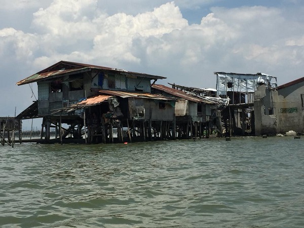
Photo Credit: AKAP KA-Manila Bay
Results
The Team
- John Warner Carag, AGHAM project coordinator/community representative, [email protected]
- Joy Santiago, Chief Science Research Specialist, University of the Philippines Resilience Institute, [email protected]
- Jerico E. “Jake” Mendoza, University of the Philippines | UPD · UP Resilient Institute, UP NOAH Center, [email protected]
The Challenge
Bulacan is a province in the Philippines just north of the national capital region of Manila. At 34% poverty incidence, fisherfolk comprise one of the poorest sectors of Philippine society yet contribute greatly to the country’s food security. However, these communities are in danger of being displaced, their sources of livelihood destroyed, and the environment at risk in order to make way for massive land reclamation projects that claim to be development projects that will improve the economy and local communities’ everyday lives. The San Miguel Corporation (SMC) has plans to develop a 2,500-hectare Aerotropolis. The project is planned to be a metropolitan subregion where the layout, infrastructure, and economy are centered on an airport which serves as a multimodal “airport city” commercial core. Construction of the Aerotropolis would require removal of the already-vulnerable coastal communities.
The Methods
The Bulacan community science team used satellite imagery, hazard data, and field work data to assess the physical condition of the study areas. They used Geographic Information System (GIS) for map creation and assessment of the study areas. The team collected data via field surveys and online data sets.
The project team met almost once a month via Skype and several times (3-4 times in person to discuss the context and objectives of the project. In addtion, they discussed any troubleshooting issues and individual roles and responsibilities, as they evolved. Overall time involved: approximately 2 months for doing the maps starting from data collection to production of maps.
The Results
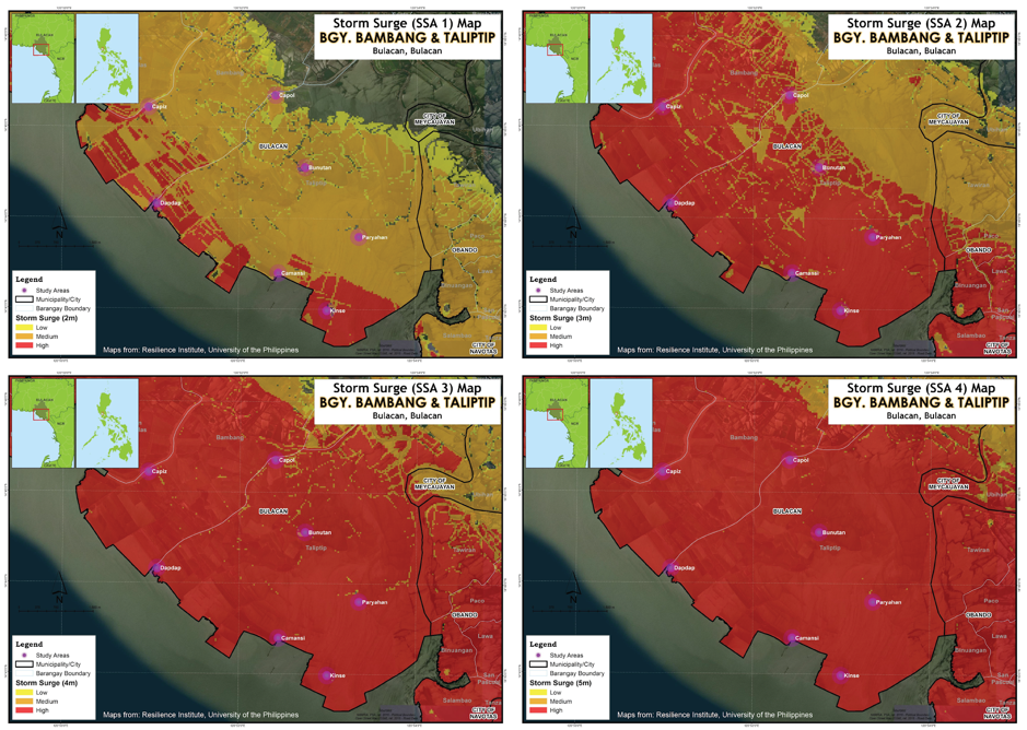
The team produced three types of maps: storm surge maps, flood maps for different scenarios and location maps.
- Thirty-five families were interviewed in 7 sitios (part of a barangay, in this case a coastal island community), and focus group discussions were done to verify the maps and get historical accounts of geohazards that affect the area (mainly storm surges and floods).
- The community members of Taliptip, Bulakan, Bulacan were given a short workshop on how to read the maps, putting emphasis on which areas are most vulnerable to disasters for each storm surge and flooding scenario.
- The maps produced were used to articulate the hazards in the coastal communities in Taliptip, Bulakan, Bulacan through a community gathering in a church. This was attended by at least 30 people from 3 out of 7 coastal island communities in Taliptip.
- A report on the geohazard present in the area, the possible impact of the aerotropolis, and the perception of the communities on the construction of aerotropolis was completed as part of a university funded project. The maps produced through this collaboration were used in the report. The following were some of the conclusions and the recommendations:
- In the past ~60 years, flooding and storm surges were regular events, especially during the rainy season. Flooding due to high rainfall events are due to the release of water from dams which increases river discharge and inundates the communities near the rivers. Storm surge heights rise to 4 meters according to accounts of community members, consistent with the storm surge maps.
- Although the area faces perennial geohazards, they have an early warning system set-up, in which storm advisories are routinely sent through text message by the barangay captain to the officer-in-charge for each coastal community. In the aftermath of storms and flooding events, destroyed houses and properties are readily rebuilt from house debris. In the case of Sitio Kinse, where storm events flood or even erode one side of the island, residents rebuild their houses on high stilts and stay for days in their neighbor’s houses on the elevated part of the sitio. No death or injury were reported in the past ~60 years due to these geohazards.
- Concerning the threat of displacement due to the construction of the aerotropolis by San Miguel Corporation, the households from the seven communities interviewed were almost unanimously against this reclamation project. Residents cite loss of livelihood, absence of alternative livelihood skills, loss of residence and identity, and high cost of living in the mainland as the main reasons why most of them would choose to stay in the area amidst perennial geohazards.
- The construction of the Bulacan Aerotropolis causes temporary and permanent changes which impact the social, physical, and environmental resources of the communities living nearby. It is important that these effects are studied properly, incorporated in the planning and design of the project, and strictly implemented during operation.
- Although San Miguel Corporation offers relocation for some of the affected communities (Lucas, 2019) the lack of or non-disclosure of any concrete plans prevents authorities and experts from assessing the hazard risks in the purported relocation sites. This may inadvertently expose the residents to more hazardous environments wherein the residents may not have the resilience to cope with. Also, relocation may cut off residents from accessing their livelihood and destroy their community structures, thus gravely weakening their abilities to recover once a hazardous event occurs. It is recommended that San Miguel Corporation involve the residents of Taliptip, Bulacan and the public transparently and democratically in every step of the project – before, during, and after project proposal and implementation.
- Deltas, wetlands, and lakes are not ideal for airport construction because they are they have alternating layers of sand, silt, and clay, which are geotechnically problematic, i.e., low shear strength, compressible, expansive, and liquefiable. Although technological and engineering remediation may provide some solutions, developed countries like Japan, USA, UK, Norway, France, Italy, and Russia continue to face challenges in design and construction.
- The large-scale development of northern Manila Bay into an aerotropolis and business centers, which would attract immigration, may increase the hazard vulnerability of future workers, residents, and establishments. It is highly recommended that the project proponents consider an alternative site location and reduce the scale of the Bulacan aerotropolis project.
This project enabled the communities in Taliptip, Bulakan, Bulacan to better understand and prepare for geohazards (e.g. storm surge and flooding) that their area may face in case of extreme events. Because of this project, they now understand that they would need to be more vigilant and if possible, look for a better site where they could build their houses. At the same time, many have come to understand that these geohazards should not be used to justify being displaced from their homes. They now know that building a large-scale project such as an aerotropolis would not only impact their locality but may exacerbate the hazards in other areas as well.
In the case of the community members, they use their interaction with researchers and the possible impact of the aerotropolis to organize themselves and others and to express their dissatisfaction against the impending construction of the aerotropolis.
Reflections
Some factors that contributed to this team’s success include:
- Constant communication with the community organizers and people on the ground; and,
- Consultation with social scientists.
For those seeking to do community science projects, the team recommends that those teams engage in constant engagement with everyone involved (e.g. AGU – Thriving Earth Exchange, community members, and scientists) especially when it comes to they types of outcomes that are possible given a limited time and limited resources.
Description
Fisherfolk and their larger communities depend on the ecosystem of the Manila Bay coastal areas of Bulacan for their livelihood, for example, the 40,000 residents of the municipality of Paombong, Bulacan. Bulacan is a province in the Philippines just north of the national capital region of Manila. At 34% poverty incidence, fisherfolk comprise one of the poorest sectors of Philippine society yet contribute greatly to the country’s food security. However, these communities are in danger of being displaced, their sources of livelihood destroyed, and the environment at risk in order to make way for massive land reclamation projects that claim to be development projects that will improve the economy and local communities’ everyday lives.
While reclamation projects can be a source of much needed development that local communities need, the current findings from an expert geologist strongly suggest that an urgent and extensive research study needs to be conducted to mitigate—if not altogether prevent—the possible harmful effects on the environment and the people that these projects may cause in Bulacan. The specific objective of this project is to understand the impacts of reclamation and road projects along Manila Bay upon the community of Bulacan.
Residents have reported that representatives of so-called Silvertines Incorporated, an alleged consortium of big investors in the Philippines, have been bothering them about buying out vast areas of fish ponds. Over 3,000 hectares of fish ponds have already been procured. Fisherfolk have started to experience dwindling catches due to large-scale fish cage farms now operated by Silvertines Corporation.
Further, the San Miguel Corporation (SMC) has already published several press releases about developing a 2,500-hectare Aerotropolis. The project is planned to be a metropolitan subregion where the layout, infrastructure, and economy are centered on an airport which serves as a multimodal “airport city” commercial core. Construction of the Aerotropolis would necessarily require removal of the already-vulnerable coastal communities.
With preliminary consultation from University of Illinois at Chicago geologist Dr. Kelvin Rodolfo, the community has learned that the reclamation project has a lethal risk for aggravating geophysical hazards. In particular, the hazards include danger of land subsidence; danger of storm surge and strong waves caused by typhoons; and danger from seismically induced liquefaction.
The project would have far-reaching impacts beyond the province of Bulacan. San Miguel Corporation’s Aerotropolis is only part of a larger reclamation project called the Manila Bay Integrated Flood Control, Coastal Defense, and Expressway Project proposed by the Coastal Development Consortium (CDC). The CDC is composed of the New San Jose Builders Inc. and the San Miguel Holdings Corp., a subsidiary of the San Miguel Corporation. Later, this project could be replicated to cover not only the coast of Bulacan but also the provinces of Pampanga and Bataan. The output of the project will not only inform, but also empower affected communities for education and awareness building to strengthen the community-based organization and lobbying with the legislators for policy advocacy.
Feny Cosico and John “Warner” Carag have selected Joy Santiago and Jake Mendoza as their scientific leads. Joy and Jake will:
- Investigate ecological impact in the sources of fill material and disposal of unsuitable in-situ material;
- Assess risks of land subsidence; storm surge and strong waves caused by typhoons; and seismically induced liquefaction;
- Evaluate erodibility, hydraulics, and geologic conditions of the site;Sub-surface investigation, in-situ testing, and laboratory testing; and
- Model the predicted changes in coastal water circulation, water quality, pollution, erosion, high storm surges, heavy metals and toxins, and/or flood and typhoon risk.
The community anticipates that Joy and Jake will:
- Contribute to the development of a white paper to be used by the community in an education and advocacy campaign;
- Provide access to/necessary equipment for field work; and,
- Have access to and be able to facilitate laboratory testing, as necessary.
This project started in February 2019 and will take approximately 6-8 months to complete.
Project Team
Community Leads
 Warner Carag is a biologist and the Secretary-General of Advocates of Science and Technology for the People or AGHAM – Diliman Chapter. Warner served as a biologist during AGHAM’s Environmental Investigation Mission which assessed the impact of the Jalaur River Multi-Purpose Project in Panay island, Philippines, the first large scale dam project in the Visayas area. He is also a graduate student in the National Institute of Geological Sciences, University of the Philippines – Diliman.
Collaborating Organizations
AGHAM-Advocates of Science and Technology for the People is the partner national organization. AGHAM, is an organization of patriotric, pro-people science and technology advocates, bounded together by a common interest of promoting science and technology that genuinely serve the interest of the Filipino people, especially the poor.

Status:
Complete,
Location:
Bulacan Province,
Philippines,
Managing Organizations:
Thriving Earth Exchange,
Project Categories:
Natural Resources,
Project Tags:
No tags