
Identifying Gaps in Urban Flooding Reporting in Durham
Durham, North Carolina, United States
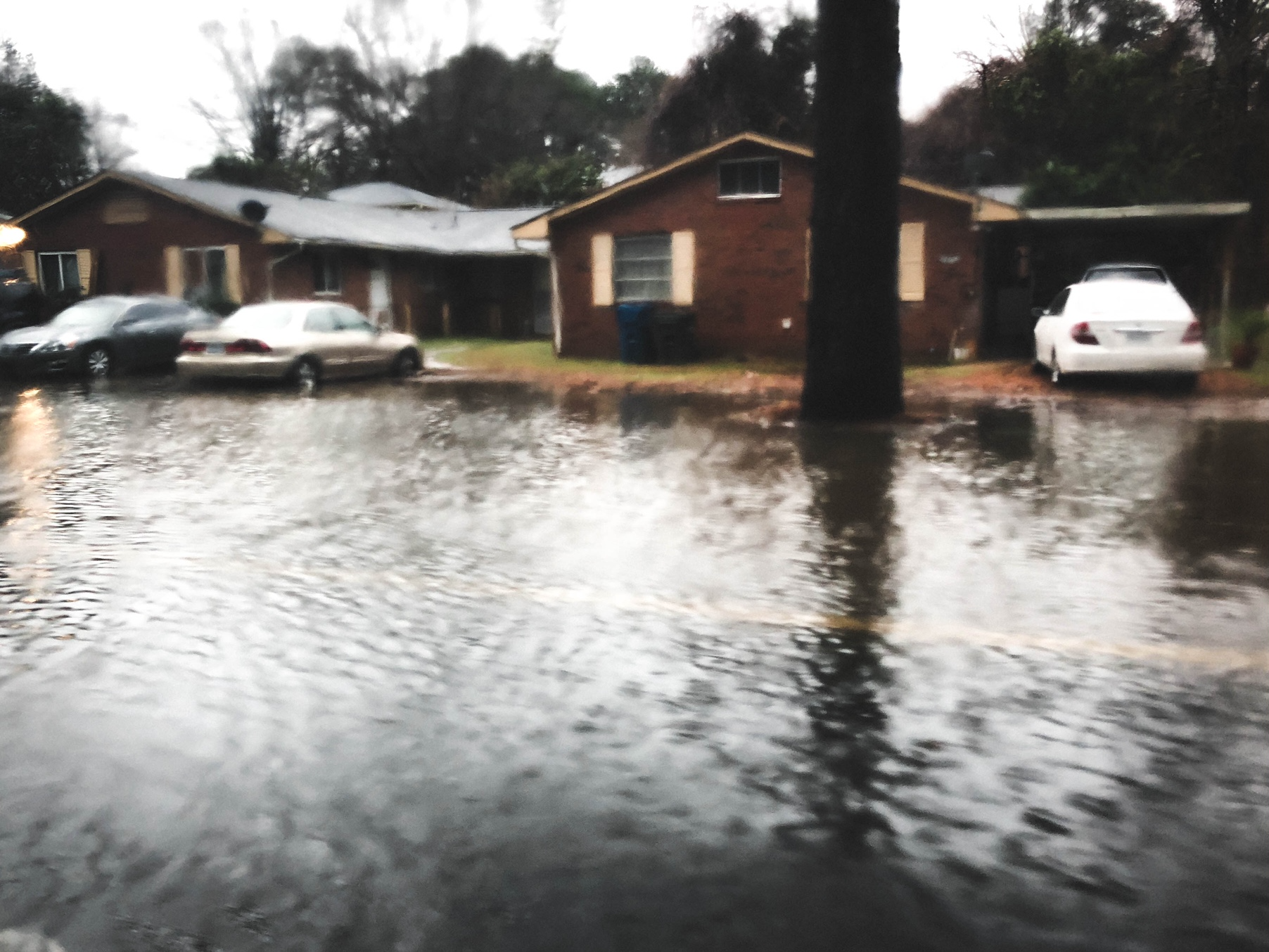
Flooding in Durham. Photo courtesy of Steve Anderson.
Urban flooding is an underreported health and economic risk to residents of urban Durham, North Carolina neighborhoods. The Durham city website has a robust reporting mechanism and a One-Call System that allows residents to report flooding issues. These reporting systems are influential in determining how and where relevant civic funds are allocated for fixing infrastructure and protecting communities against flooding threats. This project aims to identify the gaps in flood reporting that may lead to a lack of flood prevention investment in communities that need it.
Description
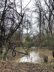 Photo courtesy of Steve Anderson.[/caption]
In brief:
- City of Durham
- Southeastern city still struggling with the consequences of redlining and discrimination
- Urban Flooding
- Durham’s web reporting and One-Call systems are meant to be easily accessible ways to report urban flooding, which helps to dictate investment in potential solutions.
Urban flooding is a traumatic and critical health and economic hazard to Durham residents, and equitable infrastructure to protect communities begins with equitable access to reporting tools.
Urban Durham is vulnerable to flooding events because of a confluence of factors, including an increase in extreme precipitation and aging infrastructure. Durham is already experiencing a substantial increase in extreme rain events, including a 129% increase in heavy rain events from 2005–2014 compared to the 1950–1959 period.
The impacts of these extreme rain events are not evenly distributed throughout the city’s neighborhoods and vulnerability to the resulting flooding events are based on intersecting social, economic, and environmental determinants of health. Although residents can advocate for safer conditions and report flooding events using the One Call system or online reporting form developed by the City of Durham , there has not yet been an analysis of how well-known this system is, how widely used it is, and how accurate it is in reporting all urban flooding events.
The Project
We aim to identify where urban flooding is happening most, where future occurrences are most likely and where current reporting is happening most often. This will allow us to see if gaps exist, and if there are patterns in where and why these gaps might exist.
We would like to be able to identify these gaps both geographically and in terms of the relevant social and economic determinants of health, and better understand why this flooding is being reported less. Understanding the barriers to flood reporting is an important step toward engaging residents in learning more about where and how to report flooding.
The project also aims to publicize and communicate the existing gaps via effective publicly available data visualization, and materials aimed at building visibility of the risks of urban flooding and how to report it.
Project Team
Community Leaders
Steve Anderson is the Data and Monitoring Coordinator for Ellerbe Creek Watershed Association (ECWA), and has a dual appointment as a research ecologist in the Duke River Center. His background is in conservation using field and geospatial data to learn about patterns of change in a human-dominated world. He manages monitoring efforts conducted by ECWA and academic partners in our local urban and rural watersheds, and connects student’s research interests with the needs of community organizations in our city. Steve has been working with local partners to develop a new Creek Watchers program in Durham that offers equitable opportunities for community-led participatory research on water quality and urban flooding. He is passionate about studying how human activities and climate change impact the health of forests and streams.
Keshi Satterwhite, is the Community Relations Director for the Ellerbe Creek Watershed Association (ECWA). Keshi created The Watershed Academy (TWA), an equitable community engagement model that builds awareness of climate resilience. TWA began in 2019 and focuses on community residents who desire to become a steward and advocate for Green Stormwater Infrastructure (GSI) and Environmental Justice (EJ) in their neighborhoods. The Watershed Academy equips participants with educational tools to lead land conservation efforts, clean water initiatives, community garden projects, and flood mitigation best practices in their neighborhoods. Keshi has dual bachelor’s degrees in Business Administration and Accounting.
Rickie White, ECWA, has been the Executive Director of Ellerbe Creek Watershed Association for the last two years. He is a research ecologist by training and has studied plant communities, restoration ecology, community science, and the interaction between natural systems and human systems. In his role with ECWA, Rickie has prioritized the need to ensure that the organization serves all neighborhoods in the watershed and strives to have board and staff diversity reflect back the diversity of the city where we all work and live.
Community Scientists
Dr. Olufemi A. Omitaomu received his PhD degree in Industrial Engineering with concentration in Information Engineering from the University of Tennessee. His BS and MS degrees are in Mechanical Engineering. His areas of expertise include artificial intelligence in energy systems, anomaly detection in complex systems, and cognitive coupling of human-machine interactions.
Dr. Esther S. Parish has been a researcher with ORNL’s Environmental Sciences Division for over 10 years. Dr. Parish leads interdisciplinary research projects for the US Department of Energy’s Office of Energy Efficiency & Renewable Energy, including “Quantifying & Visualizing Progress Toward Sustainability” for the Bioenergy Technologies Office (BETO) and “Environmental Decision Support: Science-Based Tools for Hydropower Stakeholder Collaboration” for the Water Power Technologies Office (WPTO). Esther’s primary research interests include utilizing geographic information science (GIS) and integrated models and datasets to assess (1) potential tradeoffs between environmental and socioeconomic indicators of sustainability and (2) climate change impacts on human populations and water resources. With a Ph.D. in Energy Science & Engineering through the Bredesen Center for Interdisciplinary Graduate Research and Education, an M.S. in Geography from The University of Tennessee, and B.S. in Geology & Geophysics from Yale University, Esther has expertise in landscape ecology, sustainability indicators of renewable energy resources, watershed hydrology, and pollution prevention. Dr. Parish has published over 35 articles in a variety of journals, including Applied Energy, PNAS, Ecology & Society, Ecological Indicators, Environmental Management, and Computers & Geosciences.
Phil Nugent is a Systems Architect in the Geoinformatics Engineering Group at Oak Ridge National Laboratory. During his 12 years at ORNL, he has worked on developing distributed, geospatial data systems and informatics platforms focused across many domains, including transportation, energy resilience and situational awareness, and geospatial intelligence. Mr. Nugent received a Bachelor’s degree in Geography and a Master’s degree in Civil Engineering from the University of Tennessee.
Robert Feldstein is an undergraduate student studying environmental engineering at Cornell University. For the summer of 2022, he worked as a Science Undergraduate Laboratory Intern (SULI) underneath Dr. Esther Parish and Dr. Olufemi Omitaomu researching urban flooding in Durham, NC. He is particularly skilled in analyzing precipitation from global climate models using python, and performing statistical analysis in ArcGIS. Robert hopes ECWA will use his computational analysis to perform outreach across the city, and has created outreach materials to help their mission.
Community Science Fellow

Max Cawley, Fellow, MLS – Max is an educator, researcher, evaluator, and science communicator with the Museum of Life & Science in Durham, NC. He is a firm believer in participatory, democratic, and responsible science and dissemination, and I believe that anyone and everyone can, and should, contribute to our growing understanding of the world. He believes that more robust, accessible, equitable, and Just engagement with science is a matter of democratic right, and that building a more climate-engaged public is key to maintaining a healthy democracy in a warming world.
Collaborating Organizations
Ellerbe Creek Watershed Association – Ellerbe Creek Watershed Association is working to widen the water movement in Durham and beyond. In its healthiest places, the banks of Ellerbe Creek teem with creeping phlox, wild ginger, and Jack-in-the-pulpit, the water flowing through groves of red buckeye, river birch, and black gum. In its most polluted places, the banks of the creek are crowded with invasive privet and lesser celandine, its twists and turns choked with plastic bags, styrofoam cups, and other trash.
Due to Durham’s industrial past, it has been many years since each mile of this creek was healthy and thriving, when children could swim and play on its banks, or catch fish in its deeper pools. Today, many parts of the creek are simply uninhabitable for wildlife and too polluted for children to safely play.
But our watershed, which has been on the list of North Carolina’s most polluted water bodies since 1998, remains a vital source of clean drinking water for more than half a million people. That’s why we’ve been working since 1999 to protect and restore the land within our watershed. We are engaging the neighborhoods around Durham’s creeks to join us in advocating for our community’s most vital natural resource: our water.

Museum of Life and Science – The Museum of Life and Science is a 75-year-old Science Center and place for lifelong informal learning in Durham NC, located along part of the Northern end of the Ellerbe Creek.
![]()
Status:
Complete,
Location:
Durham,
North Carolina,
United States,
Managing Organizations:
Association of Science & Technology Centers,
Project Categories:
Flooding,
Project Tags:
No tags