
Strengthening the defense of Los Queñes: Geological risk assessment before the implementation of the La Jaula II reservoir / Fortaleciendo la defensa de Los Queñes: Evaluación de riesgos geológicos ante la implementación del embalse La Jaula II
Los Queñes, Chile
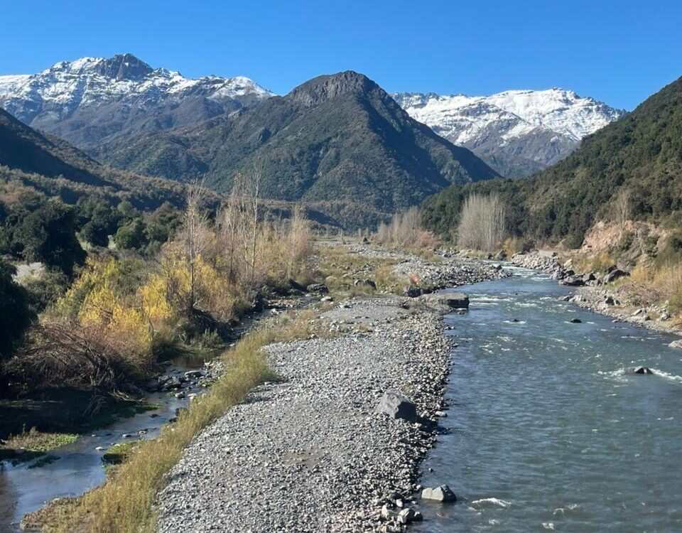
Cajón del río Teno Crédito: Matías Cavieres
The project aims to assess the geological risks associated with the potential construction of a hydroelectric dam on the Teno River, near the town of Los Queñes, Chile. To achieve this, a feasibility study will be carried out in collaboration with scientific experts and the community organization Consejo de la Defensa de Los Queñes, which has led several conservation and environmental education initiatives in the area.
The main objective is to characterize the geological and geotechnical conditions of the region, identify existing natural hazards, and analyze how these could impact the implementation of a hydroelectric dam in the area.
The study’s results will be presented through an interactive map that compiles both technical and visual information, benefiting the local community and stakeholders interested in understanding the potential impacts associated with the construction of the La Jaula II reservoir.
El proyecto busca evaluar los riesgos geológicos asociados con la posible construcción de una represa hidroeléctrica en el río Teno, cerca de la localidad de Los Queñes, Chile. Para ello, se llevará a cabo un estudio de factibilidad en colaboración con expertos científicos y con la organización comunitaria Consejo de la Defensa de Los Queñes, que ha liderado diversas iniciativas de conservación y educación ambiental en la zona.
El objetivo principal es caracterizar las condiciones geológicas y geotécnicas del área, identificar las amenazas naturales presentes y analizar cómo estas podrían afectar la implementación de una represa hidroeléctrica en la región.
Los resultados del estudio se presentarán mediante un mapa interactivo que reunirá información técnica y visual, con el fin de beneficiar a la comunidad local y a los distintos actores interesados en comprender los posibles impactos asociados con la construcción del embalse La Jaula II.
Description
About the Community
Los Queñes is a town located in the Maule Region, in the Curicó Province, approximately 200 kilometers south of Santiago, the capital of Chile. It lies at the confluence of the Teno and Claro rivers, both originating in the Andes Mountains. The area surrounding Los Queñes is known for its pristine nature and mountainous landscapes, making it an attractive destination for nature tourism enthusiasts. Popular activities include hiking, skiing, rafting, kayaking, and fishing. The area boasts remarkable biodiversity, and the rivers and mountains remain largely untouched by human activity. However, there is concern about the surrounding area, which is prone to volcanic and seismic activity.
The local community has developed a strong environmental awareness, spearheaded by the “Los Queñes Defense Council,” which promotes the conservation of the natural environment and environmental education in both schools and the community. This commitment has intensified in light of the threat posed by the potential construction of a hydroelectric dam on the Teno River, which could jeopardize the safety and livelihoods of local residents. The community is seeking the participation of a scientist with a strong background in geology to assess geological risks, including active faults, volcanic hazards, and the possibility of significant seismic events in the Teno River valley. The resulting report will empower the community with scientific authority as they strive to manage their region responsibly.
About the Project
This project aims to strengthen geological and environmental risk management in the Cajón del Teno basin (Chile) in response to the proposed La Jaula II hydroelectric dam. Through the collection and analysis of existing geological, geotechnical, and hydrological information, a comprehensive characterization of the territory will be developed, identifying natural hazards such as earthquakes, volcanic activity, flooding, and the effects of climate change. The main outcome will be an interactive map that brings together technical and visual information on terrain conditions, natural hazards, and their relationship to the planned infrastructure. This product will allow for clear and accessible communication of the potential impacts and risks associated with the dam, facilitating a comprehensive understanding of the territorial context. In addition, a community outreach activity will be conducted to present the findings and materials developed, fostering dialogue among scientists, local authorities, and residents of Cajón del Teno. Upon completion, the community will have visual and technical tools for informed decision-making regarding the dam’s viability and risks, promoting more responsible and participatory land management. This project will contribute to strengthening awareness of geological risks in Andean regions and will serve as a replicable model for other mountain basins in Chile.
Timeline and Milestones
Phase 1: Proposal Development (September 2025 – October 2025)
- Completion of the first phase and publication of the project webpage on the TEX website
Phase 2: Scientist Search (November 2025 – January 2026)
- Recruitment and induction of the scientist
Phase 3: Geological Characterization and Hazard Identification (February 2026 – May 2026)
- Gather information on studies conducted in the Teno Canyon to perform the geological and geotechnical characterization and identify natural hazards and assess how these may affect the implementation of a dam in the study area.
- Provide conclusions on the implementation of a dam after conducting the research and offer recommendations to the community on the next steps.
Phase 4: Initiate search for a scientist with GIS experience (April 2026 – May 2026)
- Recruitment and induction of the scientist
Phase 5: Creation of an interactive map (June 2026 – August 2026)
- Develop an interactive map with images, information, and technical maps based on the collected data: description of the study area (hydrology, climate, geology, soil, geotechnics), natural hazards and risks, and how these may affect the dam’s implementation.
Phase 6: Share (August 2026 – September 2026)
- Organize a community meeting/webinar/Zoom call to share the project results with the community.
- Share the project on the Thriving Earth Exchange blog and other platforms.
Contexto de la comunidad
Los Queñes es una localidad situada en la Región del Maule, en la Provincia de Curicó, aproximadamente a 200 kilómetros al sur de Santiago, la capital de Chile. Se encuentra en la confluencia de los ríos Teno y Claro, ambos provenientes de la Cordillera de los Andes. El entorno de Los Queñes destaca por su naturaleza prístina y paisajes montañosos, lo que la convierte en un destino atractivo para los amantes del turismo de naturaleza. Entre las actividades más populares se encuentran el senderismo, el esquí, el rafting, el kayak y la pesca. La biodiversidad de la zona es notable, y los ríos y montañas aún no han sido sobreexplotados. Sin embargo, existe preocupación por sus alrededores, que albergan posibles actividades volcánicas y sísmicas.
La comunidad local ha desarrollado una fuerte conciencia ambiental, liderada por la organización “Consejo de la Defensa de Los Queñes”, que promueve la conservación del entorno natural y la educación ambiental tanto en las escuelas como en la comunidad. Este compromiso se ha intensificado ante la amenaza de la posible construcción de una represa hidroeléctrica en el río Teno, que podría afectar la seguridad y los medios de vida de los habitantes. La comunidad busca la participación de un científico con sólida formación en geología para evaluar los riesgos geológicos, incluyendo fallas activas, peligros volcánicos y la posibilidad de eventos sísmicos importantes en el valle del río Teno, cuyo informe ayudará a reforzar a la comunidad con autoridad científica mientras buscan gestionar su región de manera responsable.
Objetivos del proyecto
Este proyecto busca fortalecer la gestión del riesgo geológico y ambiental en la cuenca del Cajón del Teno (Chile), frente a la propuesta de la represa hidroeléctrica La Jaula II. A través de la recopilación y análisis de información geológica, geotécnica e hidrológica existente, se elaborará una caracterización integral del territorio, identificando amenazas naturales como sismos, vulcanismo, inundaciones y efectos del cambio climático.
El principal resultado será un mapa interactivo que reúna información técnica y visual sobre las condiciones del terreno, las amenazas naturales y su relación con la infraestructura proyectada. Este producto permitirá comunicar de forma clara y accesible los posibles impactos y riesgos asociados a la represa, facilitando una comprensión integral del contexto territorial.
Además, se llevará a cabo una actividad de diseminación comunitaria, en la cual se presentarán los hallazgos y materiales desarrollados, fomentando el diálogo entre científicos, autoridades locales y habitantes del Cajón del Teno.
Al finalizar, la comunidad contará con herramientas visuales y técnicas para la toma de decisiones informada sobre la viabilidad y los riesgos de la represa, promoviendo una gestión más responsable y participativa del territorio. Este proyecto contribuirá a fortalecer la conciencia sobre los riesgos geológicos en zonas andinas y servirá como modelo replicable en otras cuencas de montaña de Chile.
Objeticos
- Realizar una caracterización geológica y geotécnica basada en investigaciones previas de la cuenca hidrográfica del Cajón del Teno, en Chile.
- Identificación de amenazas naturales en el área: sismos, vulcanismo, inundaciones y cambio climático.
- Establecer cómo la caracterización y las amenazas afectan al Cajón del Teno y el riesgo que conllevaría la introducción de la represa hidroeléctrica La Jaula II.
- Desarrollar un mapa interactivo con imágenes, información y mapas técnicos sobre la información recabada: descripción del área de estudio (hidrología, clima, geología, suelo, geotecnia, entre otros), represas, amenazas naturales y riesgos, y cómo estos pueden afectar la implementación de la represa.
- Realizar una actividad de diseminación con la información encontrada para que los tomadores de decisiones y la comunidad conozcan los riesgos geológicos que existen en el área y cómo estos pueden afectar la implementación de la represa hidroeléctrica La Jaula II.
- Todo material audiovisual, gráfico, y escrito utilizado en el proyecto debe ser compartido y aprobado con la comunidad en lenguaje claro y formato adecuado para uso y comprensión.
Cronología e hitos
Fase 1: Elaboración de la propuesta (Septiembre 2025 – Octubre 2025)
- Finalización de la primera fase y publicación de la página web del proyecto en el sitio web de TEX
Fase 2: Búsqueda de Científico (Noviembre 2025 – Enero 2026)
- Reclutamiento e inducción del científico
Fase 3: Caracterización geológica e identificación de amenazas (Febrero 2026 – Mayo 2026)
- Obtener información sobre estudios realizados en el Cajón del Teno para realizar la caracterización geológica y geotécnica e identificación de amenazas naturales y ver cómo estas pueden afectar la implementación de una represa en el área de estudio.
- Proveer conclusiones sobre la implementación de una represa tras realizar la investigación y dar recomendaciones a la comunidad sobre los pasos a seguir.
Fase 4: Iniciar búsqueda de científico con experiencia en SIG (Abril 2026 – Mayo 2026)
- Reclutamiento e inducción del científico
Fase 5: Creación de mapa interactivo (Junio 2026 – Agosto 2026)
- Desarrollar un mapa interactivo con imágenes, información y mapas técnicos sobre la información recopilada: descripción del área de estudio (hidrología, clima, geología, suelo, geotecnia), amenazas naturales y riesgos, y cómo estos pueden afectar la implementación de la represa.
Fase 6: Compartir (Agosto 2026 -Septiembre 2026)
- Organizar una reunión comunitaria/seminario web/llamada de Zoom para compartir los resultados del proyecto con la comunidad
- Compartir el proyecto en el blog de Thriving Earth Exchange y otras plataformas.
Project Team
Community Leads /
Matías Cavieres lives in the town of Los Queñes, a pre–Andean town in central Chile. He has been working for 30 years for his tourism company, which has cabins and adventure tourism activities such as rafting and canopy. Matías is the president of “El Consejo de Defensa de los Queñes”, working in the environmental defense and cultural heritage of his town, for 10 years now. Matías likes the outdoors and enjoys nature and rivers, and is very committed to achieving, maintaining and protecting the rivers and the customs of his community.
Matías Cavieres vive en el pueblo de Los Queñes, un pueblo precordillerano de la zona central de Chile. Hace 30 años que trabaja para su empresa de turismo lo cual cuenta con cabañas y actividades de turismo aventura como Rafting y Canopy. Matías es el presidente del Consejo de Defensa de los Queñes, trabajando en la defensa ambiental y patrimonio cultural de su pueblo, desde hace ya 10 años. A Matías le gusta la vida al aire libre y disfrutar de la naturaleza y los ríos, y por eso está muy comprometido en lograr, mantener y proteger los ríos y las costumbres de su comunidad.
Todd Ericson is from the United States, but has been living full time in Chile since 2005. He has degrees in Public Relations and Secondary Education (Language Arts and Communication) from Susquehanna University. Todd has been running Chilean Adventures since 2003 and Los Queñes River Lodge & Cabañas since 2009. As a founding member of “El Consejo de la Defensa de Los Queñes” he looks to protect the safety and best interests of his neighbors and natural environment.
Todd Ericson es estadounidense, pero reside en Chile desde 2005. Es licenciado en Relaciones Públicas y Educación Secundaria (Lenguaje en inglés y Comunicación) por la Susquehanna University. Dirige Chilean Adventures desde 2003 y Los Queñes River Lodge & Cabañas desde 2009. Como miembro fundador del Consejo de la Defensa de Los Queñes, se esfuerza por proteger la seguridad y el bienestar de sus vecinos y del medio ambiente.
Community Scientist
Jonatan Glehman is a PhD candidate at the Scripps Institution of Oceanography at the University of California, San Diego, where he studies earthquakes and early-warning systems. His research focuses on understanding how earthquakes initiate and propagate, and how geophysical observations and numerical modeling can be used to reduce seismic risk. Jonatan earned his bachelor’s and master’s degrees in Earth and Environmental Sciences from BenGurion University of the Negev in Israel. He is particularly interested in linking fundamental earthquake physics with real-world applications in hazard mitigation.
Jonatan Glehman es candidato de doctorado en la Scripps Institution of Oceanography de la Universidad de California, San Diego, donde estudia los terremotos y los sistemas de alerta temprana. Su investigación se centra en comprender cómo se inician y se propagan los terremotos, y cómo las observaciones geofísicas y la modelización numérica pueden utilizarse para reducir el riesgo sísmico. Jonatan obtuvo su licenciatura y maestría en Ciencias de la Tierra y Ambientales en la Ben-Gurion Universidad de Negev, en Israel. Está particularmente interesado en vincular la física fundamental de los terremotos con aplicaciones prácticas en la mitigación de riesgos.
Community Science Fellow
Danna Villarreal is a native Panamanian and a current PhD student in the Biological and Agricultural Engineering program at the University of Arkansas in the United States. Her research focuses on understanding how dams and agriculture jointly impact water quality in the U.S., with the ultimate goal of identifying inefficiencies in management across large-scale systems. She has international academic experience, having completed her master’s studies through the ERASMUS MUNDUS joint master’s program in Flood Risk Management. She earned her bachelor’s degree in Environmental Engineering from the Technological University of Panama. Danna is passionate about interdisciplinary topics, multicultural collaboration, and providing solutions that benefit all living beings.
Danna Villarreal es panameña y es estudiante de doctorado en el programa de Ingeniería Biológica y Agrícola de la Universidad de Arkansas en los Estados Unidos. Su investigación se centra en comprender cómo las represas y la agricultura impactan conjuntamente la calidad del agua en los EE. UU., con el objetivo final de identificar ineficiencias en la gestión en sistemas a gran escala. Cuenta con experiencia académica internacional, habiendo completado sus estudios de maestría a través del programa de maestría conjunto ERASMUS MUNDUS en Gestión del Riesgo de Inundación. Obtuvo su licenciatura en Ingeniería Ambiental de la Universidad Tecnológica de Panamá. A Danna le apasionan los temas interdisciplinarios, la colaboración multicultural y brindar soluciones que beneficien a todos los seres vivos.
Collaborating Organizations
![]()
Los Queñes Defense Council / El Consejo de la Defensa de Los Queñes
The community leaders’ organization “Los Queñes Defense Council” is dedicated to protecting the environment and conserving the Teno River. They have conducted environmental education activities for the entire community. They have also been gathering information to oppose the proposed construction of a dam on the river, just 4 kilometers from the village. This organization is deeply involved in defending natural resources and informing the community about the project’s risks.
La organización de líderes comunitarios “Consejo de la Defensa de Los Queñes” se dedica a proteger el medio ambiente y conservar el río Teno. Han realizado actividades de educación ambiental para toda la comunidad. Además ha estado recogiendo información para oponerse a la posible construcción de una represa en el río, a solo 4 kilómetros del pueblo. Está organización está muy involucrada en la defensa de los recursos naturales y en informar a la comunidad sobre los riesgos del proyecto.
![]()
Red por los Ríos Libres (Network for Free Rivers)
The Red por los Ríos Libres (Network for Free Rivers) is a platform for dialogue and collaboration that fosters the exchange of experiences and the creation of mutual support for the protection of rivers, territories, and the communities that depend on them.
It was established in August 2016 in response to the growing concerns of local communities and citizen groups over the threats facing Chile’s rivers. Guided by the principle that “a free river is a complex ecosystem without interventions such as dams or reservoirs, where local communities, fishers, tourists, and athletes can equally enjoy its ecological, social, and economic benefits,” the Network has played a key role in supporting the communities of the Maule region, particularly in the Teno River Basin, which hosted the Third Gathering of Socio-Environmental Organizations of Chile.
The Network for Free Rivers has been active for nine years and brings together organizations from the Atacama Region to the Aysén Region. More than 2,500 people have participated in its gatherings. It has been a driving force behind legislative initiatives aimed at protecting watersheds—such as the Standard for the Protection and Integrated Management of River Basins—and has provided communities with tools for territorial protection through lectures, workshops, and high-level educational activities.
Currently, the Network continues its conservation work in the Maule Region, particularly in the Mataquito River, whose tributaries include the Teno and Lontué Rivers, and has successfully replicated these efforts in other regions across the country.
La Red por los Ríos Libres es una plataforma de diálogo y colaboración en la que se comparten experiencias y se brindan apoyos para la defensa de los ríos, los territorios y las comunidades que los habitan.
Se conformó en agosto de 2016 a partir de las preocupaciones de comunidades y grupos ciudadanos ante las crecientes amenazas que enfrentan los ríos de Chile. Bajo la premisa de que “un río libre es un ecosistema complejo sin intervenciones como centrales o embalses, donde las comunidades locales, pescadores, turistas y deportistas pueden disfrutar por igual de sus beneficios ecológicos, sociales y económicos”, la Red ha sido un actor fundamental en el apoyo a las comunidades del Maule, especialmente en la cuenca del río Teno, que fue sede del Tercer Encuentro de Organizaciones Socioambientales de Chile.
La Red por los Ríos Libres cuenta con nueve años de funcionamiento y está representada por organizaciones desde la Región de Atacama hasta la Región de Aysén. En sus encuentros han participado más de 2.500 personas. Ha sido impulsora de iniciativas legales orientadas a la protección de las cuencas —como la Norma para la Protección y Gestión Integral de Cuencas—, además de entregar herramientas para la defensa del territorio mediante charlas, talleres y exposiciones de alto nivel en distintas comunidades.
Actualmente, la Red continúa desarrollando actividades de protección en la Región del Maule, particularmente en el río Mataquito, cuyos afluentes son el río Teno y el río Lontué, replicando estas acciones en diversas regiones del país.
Status:
In-Progress,
Location:
Los Queñes,
Managing Organizations:
No organizations
Project Categories:
Data Analysis,
Natural Hazards,
Project Tags:
No tags