
Assessment of the Paradise Creek Educational Park as a Local Flood Mitigation Tool
National City, California, United States
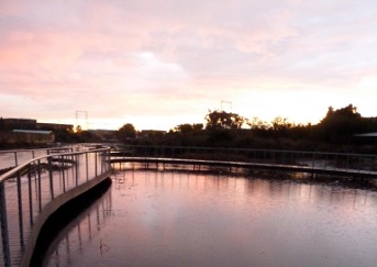
Paradise Creek Educational Park walkway view during high waters. Taken from the Paradise Creek Educational Park Inc Facebook web page (https://www.facebook.com/friendsofparadisecreek/) Link: https://www.facebook.com/friendsofparadisecreek/photos/pb.100064602647283.-2207520000/10150525138084668/?type=3
Around the National City 18th street, The Paradise Creek Educational Park (PCEP) has served the community as a place for recreation while helping in flooding mitigation. Since 1993, the non-profit PCEP has successfully stopped street encroachment, expanded and restored habitat, and planned, designed, and followed up with the construction of many improvements in this neighborhood south of 18th Street at Paradise Creek Educational Park. However, the area still experiences flooding during the year-round tides and rain events during the winter rainy season. We propose to expand the PCEP area to mitigate flooding events better while expanding a space that benefits the community and the environment.
To perform the PCEP expansion, we first need to quantify the benefit it may bring regarding water management. These benefits include flood control, habitat restoration, and potential aquifer recharge. The quantification requires a technical assessment of the proposed land change impact. We plan on comparing simulated flood inundation extents before and after the intervention. Also, depending on the resources, we would like to quantify potential changes in the aquifer recharge and benefits to the local habitat.
Expanding the PCEP area will have multiple positive impacts on the community. It would reduce the flood risk factor for the surrounding commercial and residential buildings. Also, the expansion will bring the PCEP area closer to Kimball Park, connecting two recreational regions of relevance to the city. This connectivity will benefit the community’s well-being while providing a better environment for the local habitat.
Description
About the Community
Paradise Creek Educational Park Inc (PCEPI) is an environmental organization that advocates for conserving, protecting, and enhancing the salt marsh habitats in the National City. Since 1993, PCEPI has been working on restoring PCEP to mitigate floods while developing a place that serves the community and the habitat. PCEPI has achieved its goals by expanding the PCEP area through time, partnering with other organizations, and performing educational and environmental activities. Thanks to PCEPI, currently, PCEP counts with an area of around 350,000ft^2(see Figure 1). For more information on the community, visit the PCEPI web page at https://paradisecreek.org/.
[caption id="attachment_29019" align="aligncenter" width="197"]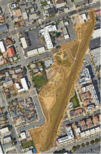 Figure 1. PCEPI current extent (in orange)[/caption]
About the Project
PCEPI’s primary goal is to expand the PCEP area north of 18th Street (see Figure 2). This expansion continues the previous four phases of the PCEP development plan. However, PCEPI requires technical assistance to demonstrate the potential benefits of it, such as flood mitigation. We aim to compare simulated flooding extent maps before and after the intervention. Our results will bring PCEPI stronger arguments to the city developers to support the PCEPI expansion.
[caption id="attachment_29020" align="aligncenter" width="300"]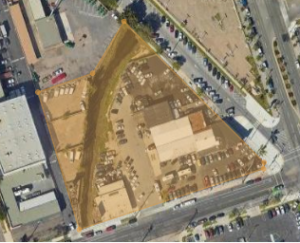 Figure 2. In orange, the proposed PCEP expansion area (100,000 ft^2)[/caption]
Flooding extent maps represent the areas below the river water level during a tidal event or an intense rainfall storm. Developing these maps requires estimating the total volume of water (e.g., rainfall) along with a simulation of the river‘s hydraulic conditions. The Federal Emergency Management Agency (FEMA) has a delineation of these maps for PCEP (see Figure 3). According to FEMA maps, PCEP and the proposed expansion align well with the most likely flooded area. Nevertheless, these maps are made on a larger scale, considering only current conditions. Higher detail maps considering the proposed scenario will provide a better decision tool for the PCEPI main goal. We envision two milestones: acquiring the required data (bathymetry, topography, rainfall) and the hydraulic simulation of the flooding maps. Once completed, we will compare scenarios with and without the PCEP expansion.
[caption id="attachment_29021" align="aligncenter" width="248"]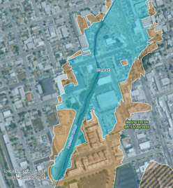 Figure 3. FEMA Flood hazard extent for the PCEP area. Blue is the most likely inundated area, and orange is the least likely (source FEMA webpage).[/caption]
Once completed, PCEPI will have evidence to support its plan to expand the PCEP area. If successful, the expanded PCEP will increase the resilience of the local community by helping mitigate floods.
Timeline and Milestones
We plan for the project to take between 12 and 18 months. We have two milestones: data acquisition and the flooding extent simulation. We aim to retrieve the data within the project’s first three months and the simulations before the 10th month. Ideally, we will have a two-month window to compare the scenarios and generate graphics that help present the project results to the public.
Project Team
Community Lead
Ted Godshalk: Community leader (description pending).
Community Science Fellow

Nicolas Velasquez: AGU Thriving Exchange Fellow.
Nicolas works as a research scientist at the Iowa Flood Center (IFC) at the University of Iowa. He has experience working on different flood-related projects in Colombia (his home country) and in the US. In Colombia, Nicolas led the team in charge of forecasting floods, fire hazards, and landslides for the metropolitan Aburra Valley region. Since 2018, Nicolas joined IFC, collaborating in developing the Iowa Flood Information System (IFIS) and the Missouri River Flood Information System (MRFIS).
Status:
Complete,
Location:
California,
National City,
United States,
Managing Organizations:
No organizations
Project Categories:
Flooding,
Project Tags:
No tags