
Coastal Flood Resilience Planning: Infrastructure Assessment, Wastewater and Debris Management, and Evacuation Preparedness
North River, North Carolina, United States
This project will develop a scientific assessment and create practical resources to improve flood resilience and emergency preparedness in the North River community of North Carolina. By mapping drainage and septic systems, enhancing communication channels, and preparing evacuation and debris management guidelines, the project aims to strengthen the community’s defenses against recurring floods. The resources produced will serve as educational tools and provide a foundation for local initiatives, helping residents adapt to environmental risks while reducing dependence on external support.
Results
Project Summary
North River is a rural, unincorporated coastal community in Carteret County, North Carolina that experiences frequent flooding, limited drainage infrastructure, and evacuation challenges during major storm events. Through this Thriving Earth Exchange Community Science project, Coastal Carolina Riverwatch (CCRW) partnered with North River community members to strengthen community-led evacuation planning and emergency preparedness using science-based tools and locally grounded feedback. The project focused on developing practical evacuation resources and documenting barriers that residents face when preparing for and responding to flooding and extreme weather.
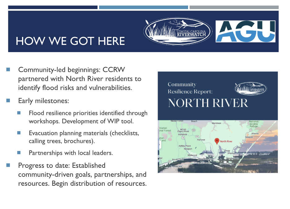
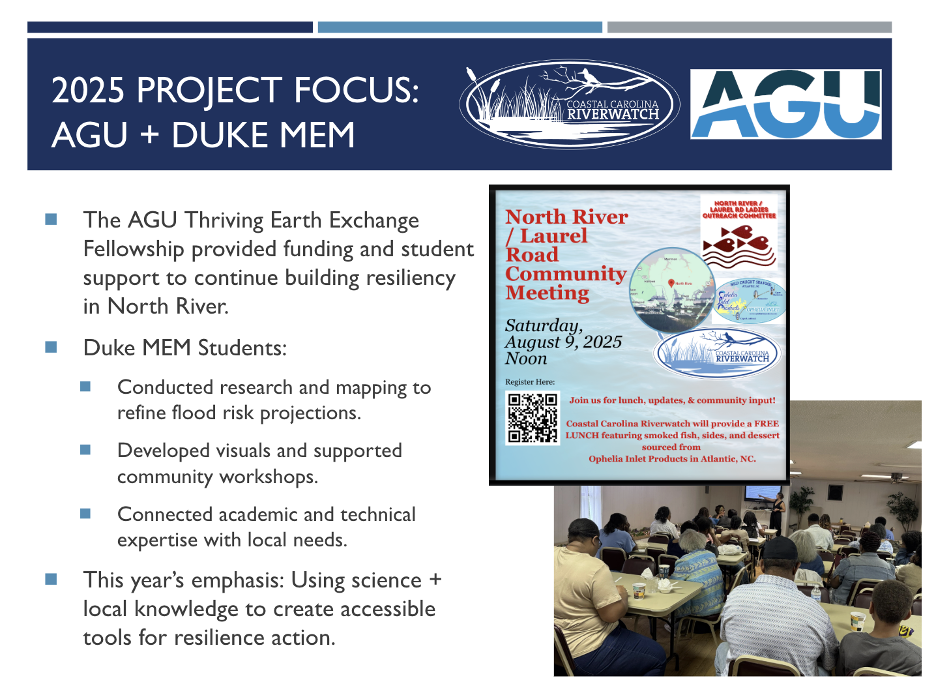
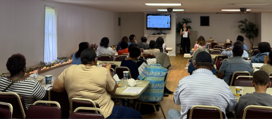
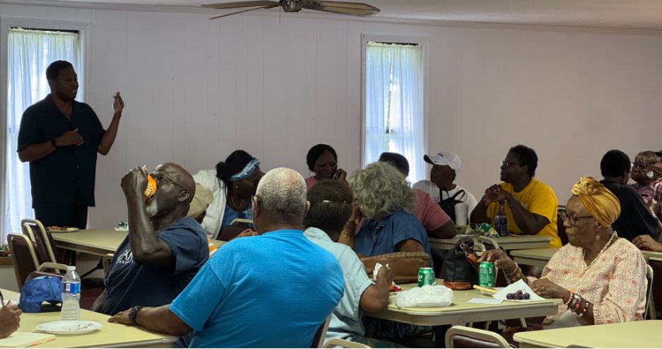
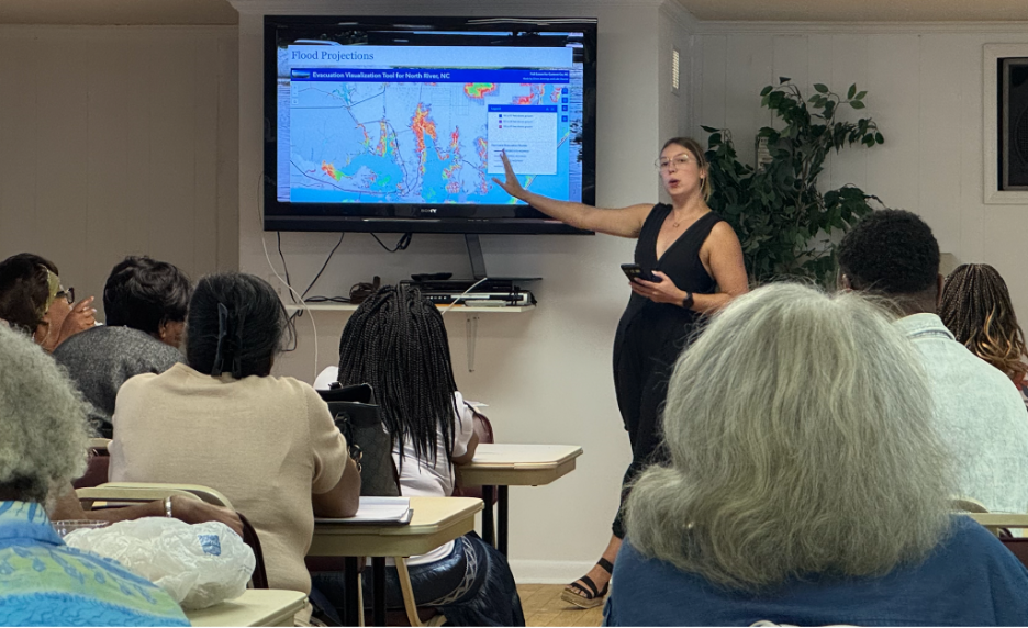
Project activities emphasized community engagement, feedback, and iterative refinement of evacuation planning tools. An in-person community meeting was held on August 9, 2025, at Mt. Tabor Missionary Baptist Church, focusing on community-led evacuation planning. The meeting shared flood risk and evacuation vulnerability information, introduced evacuation visualization and map handouts, and provided practical worksheets to support household preparedness.
Duke University students Eileen Jennings and Luke Dauner contributed research and workshop modules on evacuation barriers, vulnerable populations, and route planning. Community input was gathered through facilitated discussion, informal review of materials, and an evacuation planning feedback survey completed by 18 residents prior to finalizing project tools.
Across meetings, surveys, and follow-up engagement, approximately 60 community members participated in the project. Survey results indicated that many households had only partial evacuation plans and identified key barriers such as financial limitations and uncertainty about where to evacuate. Feedback showed strong usefulness of evacuation maps, checklists, housing assistance worksheets, and communication calling tree tools.
Project Outputs
- Community meeting on community-led evacuation planning (August 9, 2025)
- Evacuation Planning, Feedback Survey, including survey instrument and summarized results (18 responses)
- North River Emergency Preparedness presentation slides
- Evacuation planning handouts developed with community input, including an Evacuation Checklist, Housing Assistance Worksheet, Calling Tree, and “Who Ya Gonna Call?” communication worksheets
- Evacuation route and flood-vulnerability maps used for community preparedness planning are provided in the presentation
- StoryMap for North River to prioritize Resiliency Project for NC funding
- AGU and Thriving Earth Exchange presentation summarizing project activities and findings
Community Impact
This project strengthened North River’s emergency preparedness by providing locally relevant evacuation planning tools and documenting community-identified needs. Residents gained increased awareness of evacuation routes, preparedness steps, and available resources. Survey findings provide CCRW and community leaders with evidence to support future funding requests, improve emergency communication strategies, and guide longer-term resilience planning. The project reinforced trust between community members, CCRW, and scientific partners while centering lived experience in preparedness efforts.
Acknowledgements
The project team extends sincere gratitude to the residents and community leaders of North River for their time, trust, and leadership throughout this collaborative effort. We are especially grateful to Justin Wallace and Matilda Stewart of the North River / Laurel Road Ladies, whose guidance, outreach, and relationship-building were essential to meaningful community engagement and participation.
We offer special thanks to Mount Tabor Missionary Baptist Church for generously hosting the community-led evacuation planning meeting and providing a welcoming, trusted space for dialogue, learning, and collaboration. The church’s hospitality and longstanding role within the community were central to creating an environment where residents felt comfortable sharing lived experiences, concerns, and feedback.
We also extend our appreciation to the commercial fishermen of Ophelia Products for providing locally smoked fish for the community meal. Their contribution grounded the gathering in local culture, food traditions, and working-waterfront livelihoods, reinforcing the importance of shared meals in fostering connection, trust, and community dialogue.
This project was led in partnership with Coastal Carolina Riverwatch (CCRW), and we thank Riley Lewis, White Oak Waterkeeper, and Lisa Rider, Executive Director, for project leadership, coordination, and a steadfast commitment to centering community priorities. We are grateful to Thriving Earth Exchange and the American Geophysical Union (AGU) for their support of this Community Science project.
We also acknowledge Denissa Purba, Thriving Earth Exchange Community Science Fellow, for her facilitation, coordination, and support of the community–science partnership. Additional thanks are extended to Duke University student contributors Eileen Jennings and Luke Dauner, volunteer scientists affiliated with Thriving Earth Exchange, and all North River residents who participated in meetings, surveys, and feedback activities that shaped the final evacuation planning tools.
Future Plans
CCRW and community leaders plan to continue distributing and refining evacuation planning materials, expand outreach to vulnerable households, and pursue funding to support broader emergency preparedness and flood resilience initiatives in the North River community. Future work may include enhanced emergency communication strategies and continued collaboration with scientific and local government partners. We have recently connected with other resilience practitioners who are bringing much-needed resources and expertise to the community. The community is also considering incorporation, and we have connected resources to the community to provide guidance and insight using case studies.
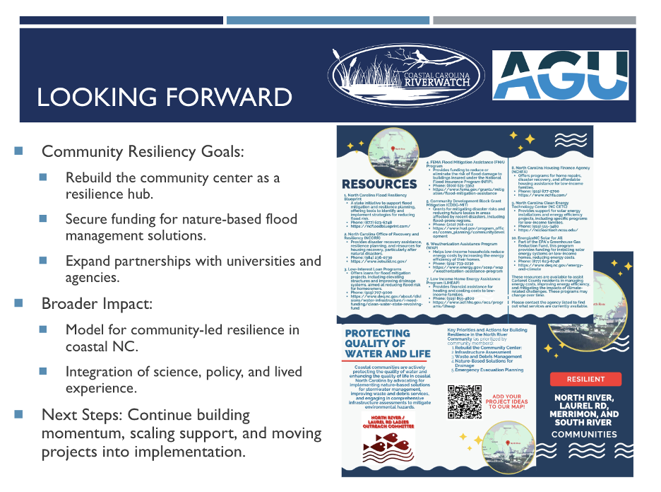
Photo Gallery
Photos included below reflect project activities and community engagement. All photos are courtesy of Coastal Carolina Riverwatch unless otherwise noted.
Description
About the Community
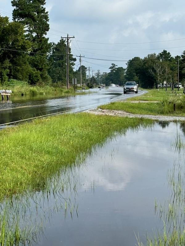
The North River community in Carteret County, North Carolina, is a rural, unincorporated coastal area known for its strong, close-knit community, primarily composed of Black residents with a significant proportion of elderly individuals. With a median income below the state average and a higher-than-average poverty rate, residents face economic challenges that add to the community’s vulnerabilities. Flooding is a persistent challenge in North River, with high-tide (sunny day) flooding, storm-driven floods, and rising sea levels frequently overwhelming its limited drainage infrastructure. The community relies on a ditch-based drainage system, which lacks the capacity to manage substantial water volumes and often becomes clogged. This stagnation causes water to accumulate, submerging roads and septic systems. As a result, access to clean water can be compromised due to potential contamination, posing significant health risks and further limiting mobility and emergency response in flood-prone areas.
Emergency preparedness in North River is particularly challenging due to limited digital communication access among its aging population. With unreliable internet connectivity and few residents using smartphones or computers, the community relies on door-to-door alerts and local efforts to disseminate emergency information. The lack of formal evacuation guidelines and dependable communication channels leaves residents vulnerable, especially during fast-developing storms. Debris management further complicates recovery; cleanup efforts depend heavily on federal disaster declarations, which only trigger support when storms reach specific hazard thresholds. As flooding and storm events increase, establishing a proactive, community-driven debris management strategy would help reduce dependency on federal declarations, ensuring swifter recovery and enhancing community resilience against recurring natural hazards.
Articles Related to the Community:
- North River Resilience Project (https://coastalreview.org/wp-content/uploads/2024/09/North-River-Resiliency-Project-Report-2024-.pdf)
- Plan in motion to build resiliency in Carteret’s North River (https://coastalreview.org/2024/09/plan-in-motion-to-build-resiliency-in-carterets-north-river/ )
- Rising Tides: Exploring the Impact and Causes of Sunny Day Flooding (https://environmentblog.web.unc.edu/2023/08/rising-tides-exploring-the-impact-and-causes-of-sunny-day-flooding/)
About the Project
The North River community, through their Thriving Earth Exchange project, seeks to enhance flooding infrastructure resilience and strengthen community resilience to flooding. The project aims to evaluate and fortify critical infrastructure to mitigate the impacts of sunny day flooding, storm flooding, and sea level rise. This effort includes assessing drainage and septic systems, identifying vulnerabilities, and developing fortification plans to ensure long-term sustainability. Additionally, the project promotes community-based flood emergency preparedness and adaptation strategies by educating residents, improving emergency communication systems, and fostering partnerships with local industries and government agencies.
The project team, composed of scientists and community leaders, will compile open-source infrastructure data, satellite imagery (such as Google Earth and Google Maps), and conduct field surveys to develop open-source datasets and a Drainage and Septic Systems Map. Data elements will include, but are not limited to, drainage locations, ditch dimensions (length, depth, width), septic tank locations, septic tank system types, and surrounding environmental conditions. All collected data will be integrated as GIS layers into the Drainage and Septic Systems Map, which will serve as the foundation for a comprehensive flooding assessment for the North River.
The next phase will focus on community adaptation and preparedness for flooding resilience. The project team will collect and compile emergency preparedness and debris management resources from federal, state, and local authorities. The team will assess current strategies and evaluate the needs for strengthening them, ensuring that preparedness efforts are effective and actionable. Additionally, the team will identify local and community services that can provide assistance and actively engage with community leaders to build local capacity for disaster response. Outreach materials will be developed to translate scientific findings into accessible formats for the public, ensuring that findings and recommendations are effectively communicated through various community engagement efforts.
Through this project, we plan to establish the following key outputs:
- Ditch Drainage Systems and Septic Systems Map to conduct the flooding assessment for the North River
- Community and Local Debris Management Guidelines for coordinated post-storm cleanup
- Stay-at-Home and Evacuation Guidelines with hands-on community training
- Community Resilience Handbook and informational flyers
Timeline and Milestones
The project divides into four sub-projects to align with the primary goals and outputs:
- Ditch Drainage Assessment Project
- Septic System Assessment Project
- Community Debris Management Project
- Evacuation Preparedness Project
12-Month Timeline:
- Throughout Project
- Continuous engagement and updates with community leaders and residents
- Ongoing development of the community resilience handbook and informational resources
- Identification and integration of relevant datasets
- November 2024 – March 2025
- Identify and onboard scientific partner(s) to support project efforts
- March – August 2025
- Execute sub-projects, incorporate datasets, and engage the community actively
- Conduct back-end data processing and integrate findings into actionable plans
- August – November 2025
- Host a community meeting to present project findings, facilitate discussion, and gather input for final adjustments
Project Team
Community Leader

Lisa Rider is the Executive Director of Coastal Carolina Riverwatch, where she has been a dedicated advocate for clean water and environmental justice for over five years. As a lifelong resident of coastal North Carolina, Lisa has made it her mission to protect both the quality of water and the quality of life in the region’s communities. With over 20 years of background in local government and nonprofit management, she leads initiatives that address pressing issues such as integrated solid waste management and industrial impacts on water quality and fisheries. Lisa is passionate about fostering the next generation of environmental advocates and is deeply committed to ensuring a resilient future for all of North Carolina’s coastal ecosystems and communities. Learn more at www.coastalcarolinariverwatch.org
Community Scientist

Riley Lewis is the White Oak Waterkeeper with Coastal Carolina Riverwatch. Riley works with local communities and stakeholders to protect the quality of water and quality of life in coastal North Carolina through surface water monitoring, research, outreach and advocacy. She received her BS in Marine Science from the University of South Carolina and her MS in Coastal and Ocean Policy from the University of North Carolina Wilmington. Her studies and research focus on water pollutants and their impacts on local communities. She believes everyone deserves access to clean water and fights for this through the collaborative work at CCRW.
Community Science Fellow

Denissa Purba is a PhD Candidate in Civil Engineering at University of Illinois Urbana-Champaign (UIUC). She holds a MSc from UIUC and a BSc from the Institut Teknologi Bandung, Indonesia, in the same field. Her research focuses on integrating electrified transportation planning, energy technology analysis, and evacuation management modeling to enhance community resilience against disasters and climate change. Denissa’s work aims to promote the adoption of alternative fuel vehicle technologies and improve the efficacy of emergency preparedness and education.
Collaborating Organizations
Nurture Nature Center

The Nurture Nature Center is a non-profit located in Easton, PA, that supports building community resiliency to environmental risk by leveraging the power of informal science education, art-centered approaches to learning, and community dialogue and networking. Started in response to flooding in Easton, NNC has over a decade of work related to flood outreach, education, and social science research. NNC is currently an AGU TEX Community Science Hub.
Status:
In-Progress,
Location:
North River,
Managing Organizations:
Nurture Nature Center,
Thriving Earth Exchange,
Project Categories:
Coastal Water,
Flooding,
Storm Management,
Water Management,
Project Tags:
No tags