
Developing a Comprehensive Flood Mitigation Strategy for Palmer Township: A Community-Driven Approach to Managing Riverine Flooding and Stormwater hazards
Palmer Township, Pennsylvania, United States
This project aims to develop a comprehensive flood mitigation strategy for Palmer Township, PA, addressing the dual challenges of stormwater management and riverine flooding exacerbated by more intense and frequent heavy precipitation events. Through a collaborative effort between the community, scientific experts, and local stakeholders, the project will leverage both community-sourced data and advanced datasets to inform local decision-making, enhance disaster response, and implement sustainable flood mitigation measures. The ultimate goal is to create a resilient community better prepared for future climatic events by developing actionable plans and educating residents on effective stormwater management practices.
Results
Project Summary
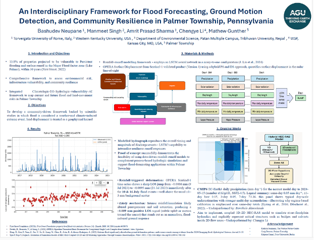
The interdisciplinary project team worked with Palmer Township, Pennsylvania, which is already coping with flooding, drainage problems, and a quieter but important risk: slow ground movement. The team evaluated flood risk and climate-related ground conditions and produced decision-ready materials by assembling open datasets (ERA5 precipitation and temperature, satellite-derived flood evidence, and displacement time series), computing 1980–2024 seasonal and annual means and trends, and preparing screening-level inundation scenarios for priority corridors such as key roads and creek-adjacent areas. The workflow followed three core steps: (1) rigorous data ingestion and QA/QC; (2) spatial and statistical analysis to detect trends and assess significance; and (3) scenario mapping using simplified hydraulic screening to illustrate where floodwater is most likely to spread under different storm conditions.
The team analysed global climate simulations alongside a modern reconstruction of past weather and found that, at township scale, native climate-model daily precipitation is not reliable for questions like “How much rain will fall on Palmer tomorrow?”, but it is useful for identifying wet and dry regimes over 3–7-day windows. This “wet-week vs. dry-week” signal can support local decisions about when to increase monitoring, pre-position crews, and communicate early with residents. To complement this, the team used Sentinel-1 SAR data to map recurrent inundation patterns and processed the same time series with InSAR techniques to quantify ground motion at millimetre scale. Along parts of Bushkill Creek the team identified slow, long-term vertical movements and a sharp displacement of roughly 9.5 mm following the July 2023 floods—a clear ground-deformation spike coincident with flooding. In parallel, the climate diagnostics show increasing cool-season precipitation, spatially mixed changes in summer totals, and consistent warming across all seasons, all of which have implications for soil saturation and future flood behaviour.
To understand who and what is most exposed, the team integrated these physical findings with social and economic data for Palmer Township. The project team examined who lives in the highest-hazard areas, what resources households and neighbourhoods have, and how quickly key services can recover after disruption. On that basis, the team developed indices of community and infrastructure resilience grounded in the “4Rs”: robustness, redundancy, resourcefulness, and rapid recovery. Over the project period the team conducted three technical check-ins and roughly a dozen briefings with local partners, and presented preliminary results at AGU 2024 and AGU 2025; feedback from these venues informed revisions to the figures, assumptions, and treatment of uncertainty.
The outcome is a transparent, township-scale framework that unifies weather and climate signals, satellite-based flood and ground-motion information, and community resilience indicators into a coherent basis for action. The final package includes reproducible maps, tables, and plain-language summaries that are ready to be incorporated into planning documents, capital programmes, and grant applications. Looking ahead, the project team intends to benchmark ERA5 and climate-model rainfall signals against local rain-gauge data, expand the event roster across additional years and seasons, and co-develop a web-based, locally led decision-support system that operationalises these tools for day-to-day flood and land-movement readiness in Palmer Township.
Poster presented in AGU2025
Project Outputs
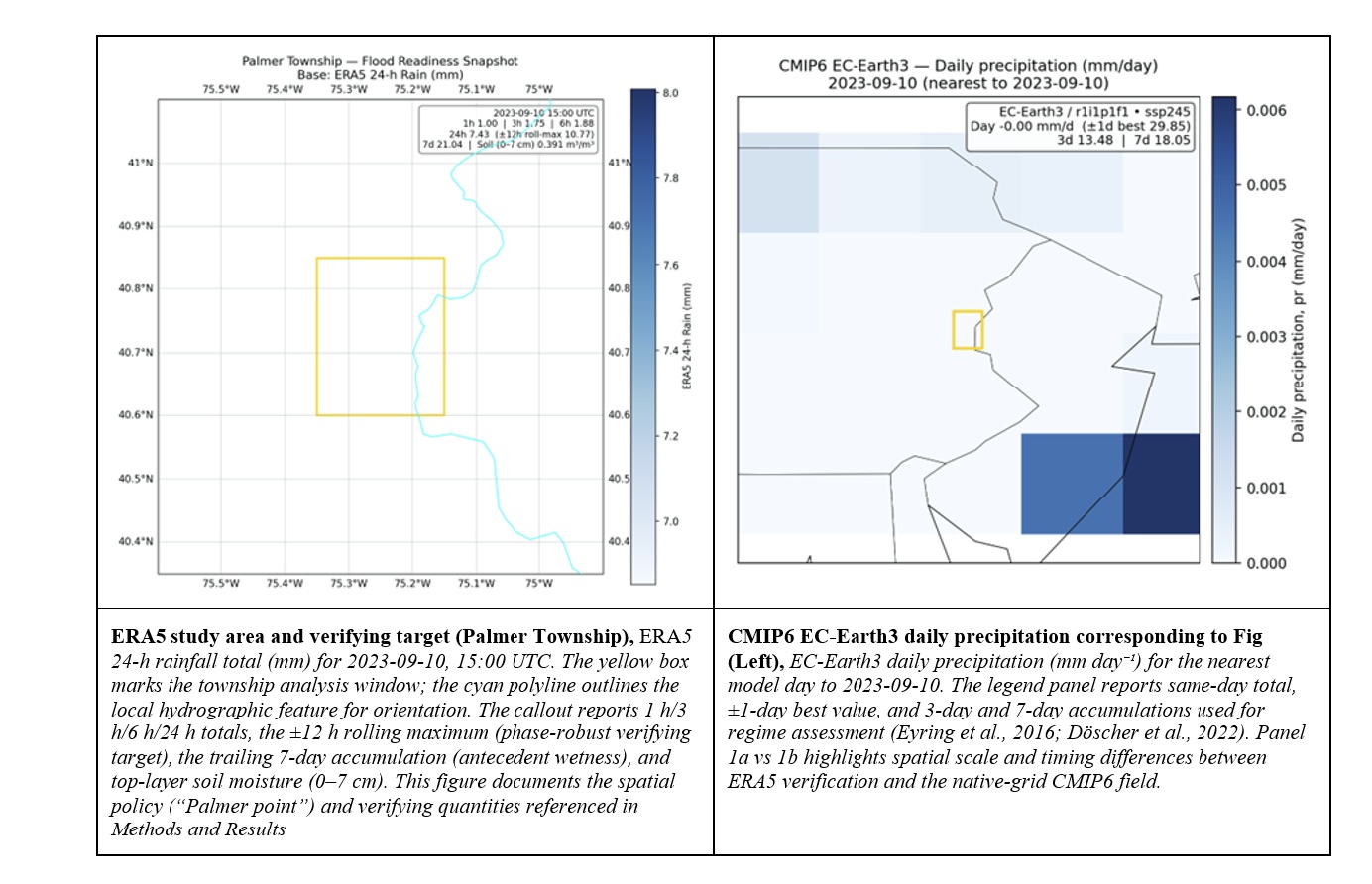
ERA5 (the ECMWF Reanalysis v5) and CMIP6 (Coupled Model Intercomparison Project Phase 6) precipitation for Palmer Township
Given the multiscale nature of rainfall and runoff, shaped by both natural variability and human activity, a hybrid, modular workflow was adopted to support sustainable flood mitigation. Prior evidence that hybrid deep/fuzzy ensembles can outperform conventional machine-learning baselines for rainfall prediction motivates this design choice. The study used a modular, scripted Python pipeline to produce reproducible and checkable results. ERA5 reanalysis was ingested from a consolidated Zarr store, and hourly total precipitation (tp) was differenced into non-negative increments and aggregated into backwards-looking windows to obtain 1 h, 3 h, 6 h, 24 h, and 7 d totals (mm)(Hersbach et al., 2023). A 24 h rolling maximum centered on 15:00 UTC (±12 h) was applied to reduce sensitivity to diurnal alignment.
All diagnostics were evaluated at the nearest available ERA5 grid to Palmer Township, two latitude rows at 40.60° and 40.85° N and a single longitude at −75.35° W, hereafter “Palmer point,” to maintain internal consistency with the available reanalysis coverage. ERA5 tp (metres) was converted to millimetres (×1000). For mapping and tables, “rain_mm” denotes total precipitation (water-equivalent) accumulated from tp increments and expressed in millimetres, aligning units with CMIP6 daily precipitation (pr, converted to mm day⁻¹ by ×86 400). The roster of objective cases was generated automatically from ERA5 calendar-day totals: one top-percentile wet day per season, three moderate days covering cool, warm, and transition months, two dry controls contrasting soil states, and a fixed comparator date (15 May 2024). The roster and associated ERA5 diagnostics were written to reproducible tables.
SAR flood-occurrence atlas
The figure presents the spatial distribution of flood-affected areas derived from ten years (2015–2024) of Sentinel-1 Synthetic Aperture Radar (SAR) observations, following the methodology of Misra et al. (2025). The global flood inundation product, generated through backscatter-based thresholding and change detection, provides an objective, observation-driven depiction of flood occurrence frequency. For this study, the Palmer Township subset of the global dataset offers valuable spatial context by highlighting areas with recurring inundation signatures, thereby supporting local validation of flood-prone zones identified through hydrologic and hydraulic modelling. This synoptic view establishes a physically consistent foundation for linking remote-sensing evidence with modelled runoff and flood exposure at the township scale.

Sentinel-1 Synthetic Aperture Radar based flood inundation from 10 years of data (2015-2024)
The modelled hydrograph reproduces the overall timing and magnitude of discharge events, reflecting the LSTM’s capability to internalise nonlinear runoff responses driven by meteorological variability. However, discrepancies remain during high-flow peaks and recession limbs, indicating the need for improved calibration, incorporation of additional catchment attributes (e.g., soil moisture, land cover, antecedent wetness), and possibly hybrid modeling with physical constraints. Nevertheless, the proof-of-concept successfully demonstrates the feasibility of using data-driven rainfall–runoff models to complement process-based hydrologic simulations and support flood-forecasting applications within Palmer Township.
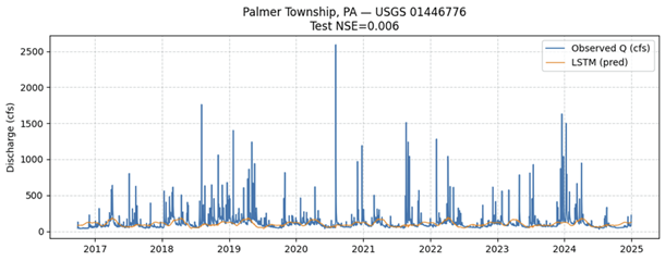
Rainfall-Runoff modelling over Bushkill Creek bl SR2017 bridge at Tatamy, PA, USGS site number 01446776. The site is 3.8 km from Palmer Township.
InSAR ground-motion pack:
Over the past 10 years, the site’s displacement remained relatively stable, fluctuating only by a few millimeters around zero. The 10-year time series (Figure) indicates that most LOS displacement values stayed within roughly ±0.003 m (±3 mm) of the baseline. These minor oscillations can be attributed to measurement noise and any small seasonal or long-term ground motions. InSAR measurements from Sentinel-1 typically achieve millimeter-level precision (Fattahi et al., 2024), and the OPERA displacement product is designed to meet accuracy on the order of ~5 mm/year (Staniewicz et al., 2025). In practical terms, random noise in an InSAR time series is on the order of a few millimeters for each measurement (Fattahi et al., 2024). Thus, the normal “background” scatter in the Palmer Township record (on the order of 1–3 mm) is consistent with the expected noise floor.
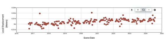
Local displacement (m) time series from 2015-2025 for Palmer Township from NASA OPERA InSAR data
Community Impact
Immediate benefits to the community include a cloud-independent flood record for validation and storytelling, and an early-warning screening for potential subsidence hotspots near waterways and infrastructure. Longer term, the combined SAR–InSAR–HEC-RAS workflow supports grant-ready justifications, asset prioritization, and routine updates after new events.
Acknowledgements
- Kathryn Semmens, Ph.D., Science Director and Grants Administrator, Nature Nurture Center
- Support Team (Julia Jeanty, Britt Forsberg) at Thriving Earth Exchange
Future Plans
The project team plans to:
- Exposure overlays for facilities and transport links; and iterative reviews with local stakeholders to conclude the modeling part
- To submit scientific article in IoP Science Journal
- Apply for further funding for making municipal scale (NASA Earth Exchange Global Daily Downscaled Projections or AGU Grant finder)
Description
About the Community
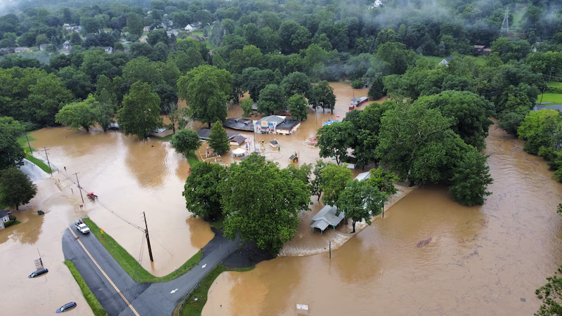
Palmer Township is a rapidly growing community in Lehigh Valley, PA, with a population of approximately 23,000 residents (about the seating capacity of Madison Square Garden). Historically a rural agricultural village, Palmer Township has transformed into a diverse suburban municipality over recent decades. This growth has brought numerous challenges, particularly concerning stormwater management and flood mitigation, exacerbated by more intense and frequent storms attributed to climate change.
Palmer Township has faced significant flooding issues, both from inadequate stormwater infrastructure and from its creeks, Bushkill and Schoeneck, which often overflow during heavy rains. The lack of proper stormwater management in older residential and industrial areas, combined with increased storm intensity, has led to frequent and severe flooding. The community seeks to understand the impacts of these events and develop actionable mitigation plans.
Palmer Township’s Hazard Mitigation Plan,
Lehigh Valley Hazard Mitigation Plan, and
About the Project
Palmer Township seeks to partner with a scientist experienced in stormwater management and riverine flood monitoring to develop a comprehensive flood mitigation plan. The project aims to leverage a combination of community-sourced data and ancillary datasets to enhance local decision-making and disaster response.
What?
- Data Types: Modeled climate projections, weather data, soil saturation, soil permeability, catchment hydrology and infrastructure assessments.
- Specific Needs: Historical and real-time data for flood mapping, UAV/Drone survey and active flood monitoring.
Where?
- Focus Area: Palmer Township, with potential scalability to other regions with similar challenges.
- Data Extent: Localized datasets with the ability to incorporate broader regional or nationwide data for comprehensive analysis.
When?
- Timeline: Immediate start with historical data review, followed by real-time data integration and continuous monitoring.
How?
- Data Accessibility: Open-source datasets requiring minimal processing, suitable for integration with existing community data collection efforts.
Key Challenges:
- Stormwater Management: Many areas lack proper stormwater facilities, leading to flooding in residential yards, driveways, and roads.
- Riverine Flooding: Creeks overflow into neighborhoods, parks, and trails, causing substantial damage to infrastructure and natural resources.
- Community Impact: Frequent flooding affects the daily lives of residents, damages property, and strains municipal resources.
Community Vision and Engagement
Palmer Township envisions a project that not only addresses immediate flooding concerns but also educates residents on stormwater management and engages them in sustainable practices. The community aims to develop a stormwater management guide for homeowners and implement infrastructure improvements to mitigate flood risks.
Community Involvement:
- Active engagement with residents through public meetings and stakeholder consultations.
- Collaboration with local partners, including the Palmer Township Stormwater Authority and Bushkill Creek Conservancy.
- Ongoing educational efforts to raise awareness and involve residents in flood mitigation initiatives.
By addressing these challenges through a collaborative, data-driven approach, Palmer Township hopes to create a resilient community better prepared for future climatic events.
Timeline and Milestones
Proposed Project Timeline:
- September 2024: Search for and select scientific partner(s).
- October-December 2024: Collaboratively identify useful datasets and prepare them for application.
- January 2025 onwards: Incorporate datasets into community science efforts, including community engagement and back-end processing.
This project will be iterative, requiring regular communication with scientific partners to adapt to the unique needs of Palmer Township and refine the approach as new data and insights emerge.
Project Team
Community Leaders

Craig Beavers serves as the Assistant Director of Planning for Palmer Township, Northampton County. Craig manages the land development process for the Township, including processing development applications, reviewing projects for compliance with local and state legislation and community goals, and overseeing construction projects. He also provides staff support to the Planning Commission and Board of Supervisors, helping to implement the 2018 Comprehensive Plan for the community. Craig received his B.A. in Administration and a minor in Business from Marywood University in Scranton, Pennsylvania, and is currently pursuing a Master’s in Urban and Regional Planning from the University of Florida. He holds professional certification as a Certified Floodplain Manager and volunteers as the Chair of the Lehigh Valley Section of the American Planning Association.
Paige Strasko is the Environmental Administrator, MS4 Coordinator, and Tree Coordinator for Palmer Township, Northampton County. She is a Certified Stormwater Inspector (CSI) and is an Environmental Science graduate from the University of Maine with experience in water sampling and testing, laboratory work, and data collection. Paige has worked with Palmer Township to develop and implement their stormwater program to remain compliant with the Municipal Separate Storm Sewer System (MS4) Permit. She has experience with stormwater education for the public, inspections of stormwater infrastructure, organizing community events, public relations and communications, and working with local volunteer organizations. Paige’s expertise is in Mycology, but she has a passion for helping build her community through her work in public service.
Community Scientists

Dr. Amrit Prasad Sharma has been engaged in disaster risk management, from policy formulation to on-the-ground implementation, since 2009. He holds a PhD in Hydraulic Engineering with a focus on hydraulic modelling for riverine floods, and he also developed the Risk-Integrated Resilience (RiR) framework that links flood risk components with resilience attributes. Dr. Sharma has gained experience working across NGO (ECO-Nepal), INGO (terre des hommes, Germany), and academic institution (Tribhuvan University, Nepal), and has also served as an expert on projects supported by UNDP, ADB, and the World Bank, pertaining to the development of river basin master plans, community-based flood forecasting systems, climate and multi-hazard risk assessments across the Hindu Kush Himalaya region. His field of interest includes to bridge the advanced expertise in open-channel hydraulics, hydrology, and flow modeling with community-based resilience approaches to inform and support evidence-based policy and planning. He currently serves as an Assistant Professor in the Department of Environmental Science at Patan Multiple Campus, Tribhuvan University, Nepal.

Manmeet Singh is Distinguished Postdoctoral Fellow at the Jackson School of Geosciences, The University of Texas at Austin, Austin, USA. He served as a Staff Scientist at the nodal national lab on weather and climate in India, Indian Institute of Tropical Meteorology, Ministry of Earth Sciences, Govt of India for 11 years from 2013-2024. He was also a Fulbright-Kalam fellow at the Jackson School of Geosciences, The University of Texas at Austin in 2021. His research interests include climate solutions to the problems on land, ocean and atmosphere using mathematical models, particularly numerical weather prediction systems. He is especially interested in AI/ML techniques, causal approaches, recurrence plots, complex networks and non-linear time series analysis for solving grand challenges in Earth System Science. He is an experienced climate modeller having contributed to the IITM Earth System Model simulations towards the IPCC AR6 report. Together with his PhD co-advisor, he developed and coupled the aerosol module of the IITM Earth System Model. He is active in teaching and has given invited talks at venues such as the NASA/UAH Seminar series, Microsoft India podcast among others. His PhD focussed on the impacts of the proposals suggesting volcanic eruptions as an analogue of solar geoengineering to halt climate change. Recently, his work has shown substantial improvements in high-impact short-range numerical weather predictions using deep learning and he has also developed novel physics inspired deep learning algorithms for high-resolution downscaling.

Dr. Chengye Li received his bachelor’s degree in civil engineering from Chang’an University,
China and earned both his Master and Ph.D. in Civil Engineering from the University of
Missouri–Kansas City, USA. His doctoral research focused on predictive flood vulnerability
assessment, integrating geostatistical analysis, sensitivity studies, and artificial intelligence
techniques. Dr. Li is currently a Water Resources Engineer at WSP, where he specializes in
climate change impacts, hydrology, and flood risk management. He is committed to
advancing climate resilience by bridging technical innovation with practical, community-
centered solutions that support both stakeholders and the public.

Bamikole Olaleye Akinsehinde, AFHEA, is a doctoral researcher in Computer Science at Aberystwyth University, Aberystwyth, United Kingdom, specialising in AI for weather and climate-related predictions, with a research focus on applying Artificial Intelligence and Machine Learning (AI/ML) to develop fuzzified neural architectures, ensemble methods, and advanced feature selection for generalisable prediction of rainfall and other meteorological variables across diverse terrains. He is a member of the IEEE and the American Meteorological Society (AMS). He has collaborated on studies addressing environmental contamination and sustainability through adsorption technologies, magnetic sorbents, seed germination under polluted conditions, bioenergy and waste reduction frameworks, as well as related environmental safety and conservation initiatives. With a BSc in Applied Physics (Geophysics), a Master’s degree in Creative App Development, and a postgraduate programme in Artificial Intelligence and Machine Learning, his research emphasises sustainable development, interpretable models, and clear uncertainty communication. His expertise includes AI research and development, weather forecasting, climate science, numerical weather prediction, predictability and ensemble forecast systems, flood risk management, environmental impact assessments (EIA), conservation programs, and the analysis of weather datasets to enhance decision-making in disaster management, with a focus on applying data science at the intersection of environmental impact and sustainable development. His skills include predictive modelling, generative AI solutions, data engineering and analysis, MLOps – building reproducible ML pipelines (data preprocessing, training, deployment), stakeholder-focused reporting, and professional training.
Community Science Fellow

Bashudev Neupane is a doctoral researcher at Tor Vergata University in Rome, Italy, and a member of the Global Alliance for Inter- and Transdisciplinarity (ITD Alliance). He possesses extensive experience in managing both non-profit and for-profit organizations and has served as a consultant to government and non-governmental agencies, as well as local, regional, national, and international organizations. He has been awarded by UNESCO for his contributions to science communication.
His expertise spans trans-disciplinary research, environmental engineering, integrated water resources management, hydrological modeling, GIS, remote sensing, data science, and water quality and quantity assessment. Bashudev has led basin and catchment scale planning and has a special interest in the criticality of infrastructure and the heritage prospects of them.
Collaborating Organizations
- Nurture Nature Center
- Bushkill Stream Conservancy
- Palmer Township Stormwater Authority
Status:
Complete,
Location:
Palmer Township,
Managing Organizations:
Nurture Nature Center,
Thriving Earth Exchange,
Project Categories:
Climate Resilience,
Community Engagement,
Data Analysis,
Flooding,
GIS,
Remote Sensing,
Riverine Flooding,
Storm Management,
Sustainability,
Project Tags:
No tags