
Adressing flood risk for small town community development
Paxico, Kansas, United States
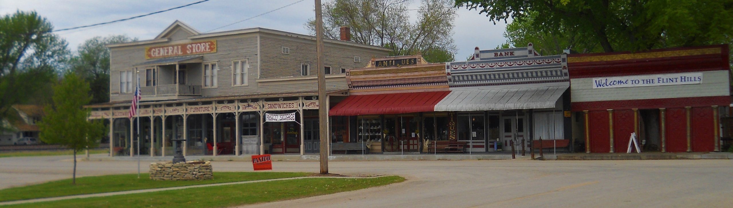
The shops in downtown Paxico, KS. Photo courtesy of Greg Dekat
Paxico is a rural small town with just over 200 residents. The majority of the town lies in a high flood risk zone, which has experienced limited economic development for over a generation. Local watershed districts and community leaders have consulted an engineering firm to reduce the risk of flooding, but proposed solutions are cost-prohibitive for this small community. We brought together local Kansas scientists with expertise in flood risk management, stormwater runoff, federal flood risk programs, and rural community development to ground-truth existing flood risk assessments and identify affordable flood risk mitigation strategies, so that the town can pursue flood risk mitigation and development opportunities.
Results
The presentation of the outcomes can be found here:
PowerPoint Presentation: “Flood Risk in Paxico, KS: Assessments and Potential Solutions)
- Storymap (Mitigating Flood Risk)
- Figure 1: Current Flow Direction (Low Flow)
- Figure 2: Flood Event Flow Direction
- Figure 3: Conceptual Drainage Improvements
Recording of presentation of project results (12/28/2021).
Project Outcomes included:
- Ground-truthing existing assessments
- Damage assessments
- Identification of potential solutions
Questions regarding the project, outcomes, and implications can be directed to Community Science Fellow Garrett Boudinot at [email protected]
Please continue reading for a description of project activities and timeline:
Description
The Community and the Challenge
Paxico was founded in 1886 as a railroad town, strategically situated along Mill Creek to sustain agricultural and municipal water needs. Unfortunately, that proximity to Mill Creek also contributes to the risk of severe floods, the most recent of which occurred in 1961. The US FEMA and Kansas Dept of Agriculture’s flood risk assessments concluded that the majority of Paxico resides in a high flood risk area (see image below), which contributes to high flood insurance rates and restricts much-needed infrastructure repairs, building projects, and development. In the words of one Paxico resident, “It’s not a flood that will take down Paxico, it’s the flood risk.” Paxico’s location along I-70, between Topeka and Manhattan (home of Kansas State University), Kansas, makes the town ripe for economic opportunities – but only if the flood risk can be effectively and affordably reduced.
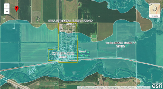
FEMA flood plain assessment map. Paxico outlined in yellow. Blue indicates “Zone A” flood risk.
After the major flood of 1961, citizens installed levies and channels to divert water away from the town. Despite these efforts, the town is still situated within a flood zone – in fact, levees installed south of town now actively retain stormwater within the town. The local Watershed District (Mill Creek, #85) is working on strategies to divert water away from the town, and community leaders are working with engineers on infrastructural solutions. Unfortunately, proposed flood mitigation strategies are very cost-intensive, which is prohibitive for a small town like Paxico that receives very little municipal revenue. If Paxico can divert potential floodwaters away from the town, it can reduce its FEMA flood risk severity and pursue further development for economic growth.
The Project
Paxico community leaders asked for help with two objectives: 1) ground-truthing assessments of flood risk, which were received by some to be excessive, and 2) identifying affordable and effective flood risk mitigation strategies so that they can reduce the risk of flooding. By doing so, they can change the flood risk assessment by FEMA, which will allow for easier and more affordable development of buildings, roads, and other city infrastructure. The community is generally against solutions that require increased taxes, and the local watershed district has experienced barriers to flood risk mitigation, such as community skepticism to outside interference. Scientists, architects, and engineers familiar with federal flood risk programs and flood mitigation strategies were contacted to help explore tangible steps that Paxico can take to reduce its flood risk under the FEMA flood risk assessment. Empowering Paxico with knowledge about the range of available flood risk mitigation solutions was seen as critical to the community’s ability to improve their infrastructure, economic opportunities, and quality of life.
Timeline and Milestones
- • September 2020, fellow Garrett Boudinot began conversations with community members and organizations in the area to assess relevant issues with Earth science contexts.
- December 13, 2020, a survey was posed to the community in the Wabaunsee County Signal Enterprise to gauge which projects were most pressing for the community. Survey results can be found here, and indicated that addressing the flood risk was one area that had high importance to the community, and could benefit from science resources.
- April 2, 2020, a science team of local experts was assembled, consisting of Dr. Kate Nelson Brock Emmerr, and Dr. Tim Keane – see description below.
- May 16, 2021, members of the science team joined city utilities supervisor Ryan Theel on a tour of Paxico during a ten-year flooding event as a boots-on-the-ground assessment of flood inundation areas. Pictures from that visit can be found here [link to storymap].
- June 24, 2021, a listening session was held with community members and the project team to hear concerns, input, and questions related to the project as it entered a “solve” phase. An announcement of the session was published in the Wabaunsee County Signal Enterprise on May 27, 2021.
- Sept 23, 2021, the science team requested input form community members on their local knowledge of flood inundation areas to compare to their geospatial and in-person assessments, providing lived-experience datasets to corroborate and compare to other data. Input was requested through a call in the Wabaunsee County Signal Enterprise and was compiled by community member Deanna Pearson.
- Dec 28, 2021, the project team presented results of the project to the city residents and leaders. The presentation can be found here [link to ppt and recorded video].
Updates
- April 19, 2021 article in the Topeka Capital-Journal “How the rural Kansas town of Paxico is looking to address its nitrate-riddenwater and floodplain issues“
Project Team
Community Leads
Ryan Theel (Paxico Utilities Supervisor)
Deanna Pearson (community member who connected TEX to Paxico)
Community Scientists
 Dr. Kate Nelson, [email protected], Kansas State University, Dept. of Geography and Geospatial Sciences. Dr. Nelson’s core areas of geographic research are in human-environment interactions and geospatial analysis and application. Her work addresses the impacts of planning and policy on the sustainability of socio-environmental systems by examining the effects of policies on hazard impacts, evaluating adaptation strategies, and developing decision support tools to help reduce vulnerability and increase resilience. She frequently employs geospatial programming and analysis methods on large spatiotemporal datasets that integrate social and physical data. She holds BS, MS, and PhD degrees in Environmental Engineering from the University of Oklahoma, Washington University in St. Louis (WashU), and Vanderbilt University, respectively.
 Dr. Tim Keane, [email protected], Kansas State University, Dept. of Landscape Architecture and Regional and Community Planning. Tim Keane has served at Kansas State University since 1984, teaching in landscape architecture and in the APDesign interdisciplinary Ph.D. Program. Keane has received multiple teaching awards, three Jarvis Endowed Chair positions, the 2009 USDA-CSREES Partnership Award for Mission Integration, the Council of Educators in Landscape Architecture’s (CELA) “Excellence in Research and/or Creative Work Award, the KSU Professorial Performance Award, and was the college’s first member to be awarded “Distinguished Graduate Faculty” status at Kansas State University. Dr. Keane’s research deals with stream morphology and process, as well as urban stormwater management. He has more than twenty peer-reviewed publications. He also has developed a series of natural systems and fluvial systems courses that provide a depth and breadth of material unusual to landscape architecture programs. He holds a BS in landscape architecture from Iowa State University, and a MS and PhD in landscape architecture from the University of Michigan.
 Brock Emmert, [email protected], Watershed Institute and Land Trust. Brock is a fluvial geomorphologist with the Watershed Institute, Inc., a Kansas not-for-profit-corporation. He holds a BA in geography and geology from the University of Northern Iowa, and a MS in geography from Kansas State University. Upon graduation at Kansas State, Mr. Emmert led a stream survey crew for 6-years documenting the dimension, pattern, and profile of Kansas streams. Since 2004, Mr. Emmert has worked for the Watershed Institute, Inc., serving as project manager for the survey, design, permitting, construction staking and oversight of streambank stabilization, natural channel design, riparian buffer restoration, and stream and wetland mitigation projects. His environmental experience includes wetland delineation determinations, endangered species habitat assessments, monitoring, environmental screening investigations, and site assessments.
Community Science Fellow
Media
Status:
Complete,
Location:
Kansas,
Paxico,
United States,
Managing Organizations:
No organizations
Project Categories:
Flooding,
Natural Resources,
Project Tags:
No tags