
Mapping Natural and Developed Resources to Positively Impact Responsible Growth
Santa Rosa County, Florida, United States

"The Waters" neighborhood under construction. Photo courtesy of Elisabeth Pavlick
This project will create a dynamic mapping platform, using GIS, with a database attached, that identifies and documents contaminated sites, including landfills and underground fuel tanks, as well as natural and built elements of flood control infrastructure, including parks, wetlands, and retention ponds. This will be used in support of community legal, political and policy remedies and ultimately will support the creation of a sustainable development plan for Santa Rosa County.
Results
The initial goals of the project were to use earth science to help the community make the case with the County for a more sustainable approach to real estate development. All of the community leaders are now mappers, to varying degrees, and able to add a visual resource to their arguments. Thanks to their ability to share the mapping tool developed by the community scientists with their social networks, commissioners, and county staff, they’ve created a growing community of empowered homeowners. There are countless examples of how they have used the mapping tool to impact positive change, and many will be discussed at AGU 2022 Fall Meeting.
From the beginning this project has been a project about storytelling. What the scientists taught the community leaders was simple – how to use an online mapping portal. What the leaders taught the scientists was invaluable – how to make a convincing argument when it matters most.
For more information about the project’s outcomes, please visit https://linktr.ee/santarosacitizens
Description
Santa Rosa County is a uniquely beautiful spot in the Panhandle of Florida between Pensacola and Fort Walton Beach. From one of the largest contiguous longleaf pine/wiregrass ecosystems remaining in the world, the Blackwater River State Forest in the northeast corner, to Gulf Breeze at the southwest tip of the peninsula along the Pensacola Bay, the county is home to a variety of flora, fauna, and natural terrain. It has also seen explosive growth and development, especially along the coastal lowlands, and this has stressed both natural resources and built infrastructure. While almost 200,000 residents inhabit just over 1,000 square miles of land, most are crowded into the coastal communities along the seaside and sound, which also swell with visitors during summers and holidays. As the effects of climate change are manifest by increasing frequency and intensity of flooding events, the impact on the community has worsened dramatically in recent years. The population has almost doubled since the turn of the millennium, with new development demanding access to water, energy, space, and other county and municipal services. All residents have been subject to subsequent loss of property value and health concerns when over-stressed storm-water recapture and sewage systems fail, or the needs of new construction supersede prudent building practices. Policy and code development have been inadequate to keep up with growth in use of county resources or to protect the natural features that attract citizens in the first place.
[caption id="attachment_25249" align="alignleft" width="300"]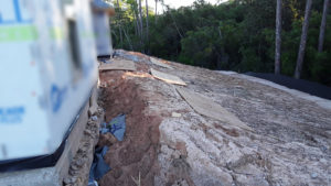 Image courtesy of Elizabeth Pavelick[/caption]
Community Leaders in the county are partnering with Thriving Earth Exchange to address this intersection of resource management and growth. Grass roots efforts of resident groups, such as Save our Soundside and Whispering Pines Concerned Citizens, have been remarkably effective in taking just-in-time action to block destructive statutes. For example, these citizen organizations – led by our Community Leaders – were successful in preventing an amendment change to the county’s Comprehensive Plan that would have adversely affected groundwater supply and quality. This project will benefit from these and other community action groups such as SRC Stormwater Runoff Mismanagement, Coalition 4 Santa Rosa’s Water Future, and Navarre Citizens for Change, who are actively collecting data and making their voices heard. Community Leaders have identified that a more accessible and complete database of natural and built elements will position the engaged citizenry to better protect future quality of life. The goal of the Community Leaders in Santa Rosa County is to see reasonable development follow a set of responsible laws which strike a balance between preserving natural resources and growth with purpose, care, and planning.
The Project
Inventorying and mapping the elements that influence quality of life in Santa Rosa County will form a critical foundation for any number of future community science initiatives, including creating and advocating for good policy, applying for FEMA and other grants, and building a sustainable development plan. This initial database, accessible through a GIS (Graphical Information System) platform, will be the basis for engaging county officials and developers, as well as building organizational capability within the community to document and track inputs and outcomes, now and into the future.
First, the team will select a mapping platform that is both effective and conformable with existing maps (https://santarosa.roktech.net/ags/gomaps4.0/index.html#). Next, the scientist will work with community leaders and other resources, such as existing lists and photos, to identify both publicly available datasets already in GIS format, as well as those that are available from websites, photos, and anecdotes. The elements that will be including on this map are both natural: wetlands, parks, green spaces, waterways, and forests; and manmade: landfills, contaminated sites, leaking underground fuel tanks, retention ponds, borrow pits, municipal recapture systems, roads, developed sites, as well as successful and unsuccessful flood infrastructure projects. Data associated with each feature will be captured in GIS layer files which can be exported in spreadsheet format as well as viewed and analyzed in maps. Ideally, an outcome of this project would be to capture or link to all permits from the GoPermits system (Microsoft Sway) and display them as a map layer. As the project takes shape, the team will make decisions regarding geographic focus and scope of various project elements.
[caption id="attachment_25247" align="alignright" width="300"]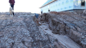 Image courtesy of Elizabeth Pavelick[/caption]
The map created during this project will serve as a foundation for future expansion and modification. It’s intended that the product of this project is a dynamic and evolving tool, rather than a final map. But the tool can be used at the project’s conclusion to present relevant observations and recommendations to county officials, developers, and other decision makers. Given time, interest and expertise, suggested solutions to revealed problems might be shown on the map, or in relation to it with rendering of a future vision. The project outcome will include a plan for continued upkeep, maintenance, and improvement of the mapping tool, as well as integration of the community science results with those featured on the county website GIS tool. In fact, those on the county mapping team may become community science leaders themselves. The desired outcome is that this community map becomes the go-to reference and an impactful tool for all efforts to build sustainable communities throughout Santa Rosa County, including applications for grants, advocacy for existing policy enforcement, and revision and updating of the county Land Development Code and zoning statutes. It will also serve as a common tool for discussion and visualization of a prosperous and resilient future.
Timeline and Milestones
This project will begin in May of 2021 and will be completed in the summer of 2022. Key milestones include:
- Selection of a mapping tool
- Identification of available public datasets (iterate with sixth milestone)
- Construction of missing but desired datasets
- Analysis of areas that suffer from repeated flooding, contamination, and/or over-development
- Creative brainstorming and visualization of possible solutions
- Integration with existing county mapping systems (iterate with second milestone)
- Present tool, analysis, and observations to county officials and developers
- Provide input to legal and policy remedies, citizen-led actions, grant applications, and ultimately, a sustainable development plan for the county
Project Team
Community Leaders:
Carmen Reynolds, Community Leader
Carmen is a citizen activist and retired Air Force lieutenant colonel, with a BS in Criminology and Law Enforcement, an MA in Business Personnel Mgt., and a BA in Journalism. Former Holley-Navarre Fire Commissioner and Zoning Board member, she’s also an award-winning journalist and copy editor. Carmen is a former co-leader of the District 4 Citizens Task Force and co-founder of Recall Florida. She leads the Coalition 4 Santa Rosa’s Water Future and the Board of Whispering Pines Concerned Citizens in Navarre. Carmen is also a member of the newly formed citizen-led Watershed Protection Committee. She delivered a well-researched presentation for the Santa Rosa County Commission on May 5, 2021, in which she identified additional protections for the East Milton Area Wellfield Protection Overlay District which services over 100,000 residents, or 54% of Santa Rosa County.
Dara Hartigan, Community Leader
 Born and raised in Northwest Florida, Dara has seen the tragic transition of the land from a pristine and ecologically balanced landscape to a barren and toxic environment – unsustainable to wildlife or for human habitat. Dara has always had a love for nature and believes people and community thrive better when they coexist. She is the founder and president of Save our Soundside, Inc., a Florida non-profit corporation that started as a grassroots organization in southern Santa Rosa County and now advocates on behalf of county citizens for reasonable development and serves as a watchdog for misconduct. Dara’s experience as a trial paralegal enables her to navigate the environmental laws, comprehensive plan, and land development code in order to propose impactful change.
Deb Bankes, Community Leader
 Deb grew up along rivers in the upper midwest and extended her love of water to diving when she moved to Florida in 1996. On the career front, Deb has held a diverse array of administrative positions; from biomedical, technical and legal; to training, marketing and sales. In 2014, her home and neighborhood were flooded due to poorly-regulated urban sprawl. Inspired by her father, the mayor of their hometown, Deb began to advocate for adequate flood infrastructure. As the founder of SRC Storm Water Mismanagement Group, a social media citizens alliance, and co-founder of an animal welfare group (and parent to several rescue pets), Deb works to educate herself on flooding and environmental laws and statues, and to engage her fellow citizens in the fight to protect her community.
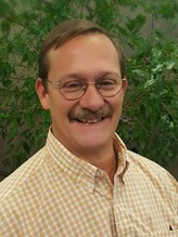
Elizabeth Pavelick, Community Leader
 As a legal assistant for almost 30 years with the Lake County, IL, State’s Attorney’s Office, Liz saw first-hand how good public servants protect their constituents from un-fettered development and its negative impact on community welfare. She retired and moved to Santa Rosa County in 2008, where she found peace and beauty walking the sandy trails with her pup on neighboring undeveloped land. In 2014, she connected with others to fight the replacement of 180 natural acres with over 350 crowded home sites. Today she advocates for smart development rather than overdevelopment, as she wants to live in a community where wetlands are appreciated for their beauty and their benefit rather than buried by fill and build – where the County embraces the natural beauty of the area while it still exists.
Sandy Dimick, Community Leader
 Sandy is a FL Master Naturalist with a B.S. in Resource Management and Biology. After college, Sandy worked as a Divemaster on boats in Key Largo, FL where she witnessed first-hand the direct connection between human activities and the many impacts to marine species. Through her interactions with marine life, she witnessed the beauty, intelligence and trusting nature of many marine species, prompting her to write a children’s book, “Manatee Mania.” Though her career took a different path in healthcare, Sandy has remained involved in local and global environmental issues and serves on the board of Save Our Soundside.
Wallis Mahute, Community Leader
 A retired graphical specialist, Wallis moved to East Milton in 1999. She has been aggressively involved in wellfield protection since 2008, when she questioned a permit application for a construction and demolition landfill on top of the Inland Aquifer that supplies 54% of the county’s drinking water. Recognizing the need for protection of the recharge area, she led a group of fellow citizens to obtain a grant supporting spatial analysis of the aquifer. As a result, a Wellfield Protection Ordinance was enacted with updated protection for potable wells. Wallis is a member of the Blackwater River Foundation, the Panhandle Butterfly House, and many other civic groups. She has attended County Commission meetings since 2008 and has twice run for Santa Rosa County Commissioner.
Community Science Fellow:
Edith Newton Wilson, Community Science Fellow
 Edith works to engage emerging professionals in energy solutions for a changing world. With degrees from Dartmouth and Johns Hopkins, Edith is a Fellow of the Society of Economic Geologists and the Geological Society. Her global career began with Amoco, bp, and Phillips, and culminated in founding Rock Whisperer, a renewable energy and climate mitigation consultancy.
Community Scientists:
Amy Richardson
Amy is a ge ologist with more than 20 years of experience in the petroleum industry, she holds degrees from Kansas State University and the University of Tulsa. She is now exploring other industries and opportunities to apply the data analysis techniques she has honed. She is looking forward to working on projects that advocate for balancing development with the preservation of ecosystems.
Chris Curb
Chris is the former Escambia County Stormwater Engineering Manager, and now continues to work via FloodDefenders.org to help people with flooding problems using his knowledge of drainage, stormwater management, flood control, municipal construction, and grant management, as well as his deep knowledge of local government processes. Chris has a BS in Civil Engineering from Auburn, and is a member of the Florida Engineering Society, the National Society of Professional Engineers, and the American Society of Civil Engineers.
Ryan Kmetz
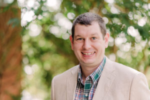
Ryan is a sustainability, climate resilience, and GIS professional who is adept at the design and deployment of interactive web-based GIS tools. He especially enjoys working with communities to bolster their resilience, empower their citizens, and create universally accessible unique solutions. Ryan has an MS in Environmental Studies and is credentialed by the Institute for Sustainable Infrastructure as an Envision Sustainability Professional (ENV SP).
Additional Resources:
- $1,000 budget from AGU/Thriving Earth Exchange
- Pro bono attorney from the ABA SEER program (pending)
Collaborating Organizations
 Anthropocene Alliance is the nation’s largest coalition of frontline communities fighting for climate and environmental justice. AA leaders face myriad challenges: damaged property, homelessness, debt, and unaffordable insurance. Supported by outstanding partner organizations that contribute expertise, grassroots leaders have successfully halted developments in flood prone areas; planned and instituted green infrastructure; organized home buyouts; and promoted clean-ups in areas that flood.
The Climate Cost Project is a data and documentary project to bring to light the costs of climate change in American communities.
Status:
Complete,
Location:
Florida,
Santa Rosa County,
United States,
Managing Organizations:
No organizations
Project Categories:
Flooding,
Project Tags:
No tags