
Updating South Tacoma Aquifer Code and Land Use Practices
Tacoma, Washington, United States
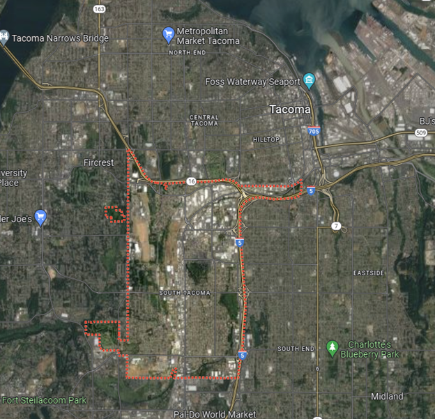
Map of South Tacoma Washington area. Google Maps 2022.
The South Tacoma Aquifer provides up-to 40% of Tacoma’s back-up water supply, maintaining the wetland, and connecting the watershed to the downstream creeks which lead to Puget Sound. Over time, the aquifer has been negatively affected by heavy industrial zoning within the groundwater/recharge area and is now threatened by pending impervious paving. The South Tacoma Groundwater Protection District (STGPD) and its current zoning overlay need to be updated to reflect modern-day knowledge for better proactive action, instead of reacting to post-contamination which continues to occur, or potential water level loss. In order to update STGPD, the team will develop a clear explanation of natural infiltration and possibly a portable aquifer model which depicts the aquifer dynamic and crucial recharge zone.
Description
About the Community
Overview Images of South Tacoma – TEX
Scientific analysis of existing STGPD and analysis of aquifer infiltration
South Tacoma is a community made up of residential, recreational, school, and business districts, yet has the worst air pollution and illness/mortality rates in the United States[1][2][3]. South Tacoma is disproportionately impacted by heavy-industrial zoning nearby. It is one of the lowest-income and most racially diverse communities within South Tacoma[4]. The community has been requesting groundwater conservation and upstream natural area conservation, which is the final region providing aquifer recharge and confluence with downstream, as well as sustaining wetland [5]. The land-code under the present STGPD limits does not include adequate consideration for aquifer recharge. A new land code for Economic Green Zone encourages the transformation of the South Tacoma neighborhood from a significantly polluted dense industry town to an eco-friendly, non-polluting, and performance-based rewards community. The need to update the land-use code for the South Tacoma neighborhood is critical since the consequences would be irreversible if the next mega-warehouse project adheres to the present land-use code, which may disrupt aquifer recharge dynamics [6]. A scientific analysis will aid STGPD in reviewing and promoting land-code updates [7] .
About the Project
To satisfy the STGPD updating requirement, practical analysis to depict recharge dynamics originating from the upstream natural area is required for the South Tacoma community to establish long-term regional aquifer sustainability. A portable and practical groundwater model will be created in a brief manner and used to data analysis. The model will include a land-use component as well as a connection between the surface hydrological process and groundwater. The goal of this model is to assess effective infiltration from upstream natural areas and its influence on the downstream aquifer.
South Tacoma community seeks to extend community participation with air quality research into local policy making once we develop a solid foundation of community-led scientific project and its application for local policy-making through aquifer conservation project for updating land use code.
The partnership between the South Tacoma community and the Thriving Earth Exchange program advances the aims of community science by having a long-term and large-scale influence on community resilience. Preventive actions are imperative. The validation of natural area’s importance and aquifer conservation’s necessity contribute to the long-term sustainability.
The analysis yield from the South Tacoma community for aquifer conservation, watershed health, and air quality serve the outcomes:
- Scientific analysis of existing STGPD (best-science review of the current existing code) and analysis of aquifer infiltration/recharge policy (since the city Planning Department is misrepresenting the vulnerability of the wells) which needs to be updated by including current best science (such as which industries’ practices are allowed or prohibited).
- Analysis of current Wellhead Protection plan (re: aquifer recharge) and impact of restricted reduced local infiltration (such as how the proposed mega-warehouse will impact three wells) and 6,000+ unmentioned contamination sources.
- Susceptibility Analysis / terrain hydrology vulnerability model (area needing examination, such as using state studies showing susceptible soil types (susceptibility analysis / 2D and/or 3-D modeling to understand the hydrological impacts prior to development, best places for infiltration), and a clear modeling of where best infiltration, contamination is and needs to be protected versus where certain practices may be allowed.
- Synergistic link between isolated studies which all need to be reviewed together (2007 infiltration policy side steps the law, allowing improper infiltration / impact on the aquifer’s health, restored Flett creek and marsh creation for ease of development permitting)… this location has been fairly stable for about 30 years so has a good control data start to then show possible negative impacts.
Timeline and Milestones
Early needs include scientific input for communicating best practices of natural infiltration/recharge from the community to city leaders. A groundwater model for aquifer conservation purpose may take six months to build (the model representing surface water-groundwater dynamic will need scientists’ input who will collaborate with South Tacoma community to decide the specific timeline). Data analysis will serve land-use code within the period of project. Milestones include feasible plan for modeling, data preparation for input, model building, infiltration scenario test, data analysis and visualization, and take-away messages for STGPD land-use code updating.
- Agree on project scope and scenarios to run
- Acquire necessary data
- Develop/calibrate model (GIS, MODFLOW)
- Conduct model runs under several precipitation scenarios
- Finalize assessment and prepare final report
- Present final report to City Council
- Share report publicly
References:
- South Tacoma – City of Tacoma. https://www.cityoftacoma.org/government/city_departments/community_and_economic_development/neighborhood_business_districts/south_tacoma
- South Tacoma Groundwater Protection District | Tacoma-Pierce County Health Department. https://www.tpchd.org/healthy-places/waste-management/business-pollution-prevention/south-tacoma-groundwater-protection-district
- Tacoma Air Quality Index (AQI) and Washington Air Pollution | IQAir. https://www.iqair.com/us/usa/washington/tacoma
- The Demographic Statistical Atlas of the United States – Statistical Atlas. https://statisticalatlas.com/neighborhood/Washington/Tacoma/South-Tacoma/Race-and-Ethnicity
- Sign the Petition. Change.org, https://www.change.org/p/say-no-to-massive-south-tacoma-warehouse-project
- senco253 A (2022) South Tacoma Industrial Warehouse Planned Above Our Largest Aquifer. South End Neighborhood Council, https://senco253.org/2022/03/07/south-tacoma-industrial-warehouse-planned-above-our-largest-aquifer/
- LRP21-0004 (2022AmendApp – South Tacoma Economic Green Zone).pdf. https://cms.cityoftacoma.org/Planning/2022%20Amendment/LRP21-0004%20(2022AmendApp%20-%20South%20Tacoma%20Economic%20Green%20Zone).pdf
Project Team
Community Leads

Heidi Stephens is an active member of community and environmental groups.
Tim Smith is a long-time social justice and environmental activist.
Community Science Fellow
Yining Bai
Status:
Complete,
Location:
Tacoma,
Washington,
Managing Organizations:
No organizations
Project Categories:
Contamination/pollution,
Natural Resources,
public health,
Project Tags:
No tags