
Mitigating flooding from the ridge to the valley through strategic planning and demonstration
Vernon County, Wisconsin, United States
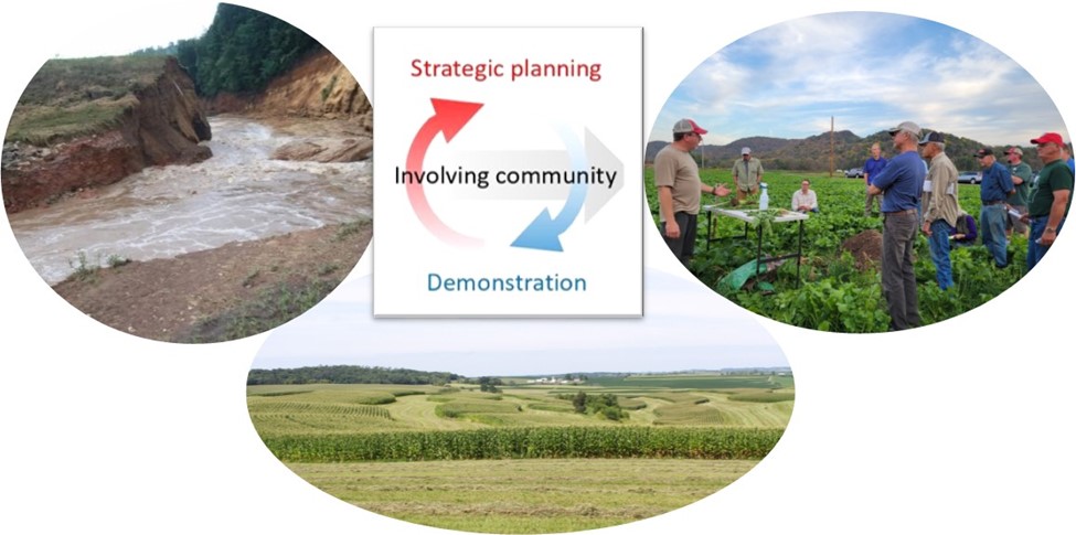
Image courtesy of Vernon County
Vernon County in Western Wisconsin is working to tackle flooding and watershed management issues in steep agricultural landscapes through nature-based blue-green infrastructure. These infrastructure refer to agricultural stormwater best management practices for erosion and sediment control, which include but are not limited to conservation tillage, vegetated filter strips, wetlands, and grade stabilization structure, etc. This project aims at evaluating the appropriate design and planning strategies of blue-green infrastructure and further develop a strategic plan potentially together with on-the-ground demonstration projects to give guidance to watershed communities, including landowners, business owners, etc., for better flooding prevention and mitigation management practices.
Results
This project was initiated in June 2022 with a goal to develop a guidebook together with some practical projects to give guidance to watershed communities, including landowners, business owners, etc., in Vernon County for them to select and design agricultural best management practices (BMPs) for better flooding prevention and mitigation. However, career changes led the project put on a pause until Jen Schmitz stepping into the Community Lead role Dr. Hassman had started in 2023.
To complete the project on a constrained timeframe, our team decided to narrow down our project scope. The team decided a site tour to Vernon County in April 2024 to understand the site conditions and the ongoing conservation works (photos below). After that, the volunteer scientist Eric Barefoot did a thorough literature review and developed an online decision-making guide for selecting appropriate agricultural BMPs. This tool can provide easy access to information about to consider the various land and water conservation practices landowners and farmers might consider for their property, and how it will work in the context of Vernon County topography and geology. The tool can be found here: vernonbmpguide.ericbarefoot.com and with the QR code below.

A brief project summary together with this tool has been shared with other local watershed management groups in December 2024, including Watersheds in Vernon County: Coon Creek, Tainter, Rush, Bad Axe, Hill Country Watershed Alliance, R2RDR(.org), Kickapoo Conversations (& Wisconsin Partners), and Fields of Sinsinawa asking for potential input or promotional support.


Reflections
The main things that contributed to the success of this project are 1) strong team collaboration and 2) expertise & execution. All team members were patient among each other, and our scientist is willing to volunteer his time to get the job done.
If the project team could do it again, they would constrain the project scope to be more confined when we first scope the project. Keeping the project to ambitious makes it hard for our scientist to get started and make progress. Another thing the team would do differently is to have more concrete action items after each meeting.
The main lessons the project team learned are that you can never predict what might happen during a project. There could be changes in the team members, project scope, etc. So you have to be versatile to changes. When a change comes, you need to react to it quickly.
Description
About the Community
Vernon County is located in southwestern edge of Wisconsin that borders the Mississippi River. This is the home for approximately 30,000 residents, mainly in three cities – Hillsboro, Viroqua and Westby; nine villages, and twenty-one towns. From small business owners to health care workers, a growing influx of newcomers alongside long-time landowners, retirees and an increasing elderly population reside here.
Agriculture roots run deep in the region with farms covering 67% of the land (337,086 acres). There are roughly 1,961 farms in the county and 98% of those are family owned for many generations. Agriculture provides 4,177 jobs and produces $715 million in economic activity. As part of Wisconsin’s driftless (unglaciated) area, the county is characterized by steep, high bluffs, forested ridges, and deeply carved flood prone river valleys. The karst landscape produces spring-fed waterfalls and trout streams throughout the region and the geology is complex with highly jointed sandstone and siltstone bedrock.
Flooding in this region has resulted in more flood-related emergency disaster declarations than in any other county in Wisconsin, causing widespread damage to public infrastructure and private property, and ongoing public safety concerns. Since 2004, there have been eight federal disaster declarations in Vernon County, causing more than $76 million in damages to properties and infrastructure. This trend towards more frequent and severe storms is expected to continue.
These events have strained the already limited resources of the affected communities. Capacity constraints and data gaps make it difficult for these communities to design flood mitigation projects and access public assistance dollars. The primary goal of this project is to identify and plan the most sustainable and cost-effective conservation practices for flood prevention and mitigation and provide other environmental benefits, e.g., pollutant reduction, habitat conservation, etc., in watersheds across Vernon County.
About the Project
The project team would like to work with the Vernon County Land and Water Conservation Department and various partnerships, e.g., local farmers, landowners, private businesses, non-profits, Wisconsin Department of Natural Resources, Wisconsin River Alliance, and Valley Stewardship Network, etc., to explore the suitable and cost-effective nature-based blue-green infrastructure (BGI) solutions for this unique agricultural landscape and share it with various watershed communities in the area, including landowners and business partners, etc., so that they can make wise decisions on local and regional flooding prevention and mitigation.
Ultimately, the project team aims at establishing a strategic plan or guidebook, which can provide maps, planning or/and design metric guidance, technical diagram illustrations, and decision trees, etc., to lead various watershed communities throughout the decision-making process for the selection and design of cost-effective BGI. In addition, the project team also hopes to develop several on-the-ground projects to demonstrate the adoption of different BGI in the community.
With the outcomes of this project, the stakeholders in the communities will be given a useful protocol to select their most suitable and cost-effective flooding prevention and mitigation strategies based on their local characteristics. Other communities can adopt similar methods used in this project to design their guidebooks. Communities with similar issues and landscape characteristics can even reference the BGI design recommendations and/or roadmaps proposed in this project.
Timeline and Milestones
- The project is set to take approximately 18 months
- Key Milestones include:
- Recruiting scientist(s) in the team
- Coverage in the local press
- Hosting a kick-off event to start the project
- Meeting with partners to get familiar with the project and community
- Summary of analysis results
- Drafting a strategic plan
- Developing a demonstration project
- Presenting the results to the public
Project Team
Community Leads
Ben Wojahn is the County Conservationist for Vernon County Land & Water Conservation. Ben is a Certified Crop Advisor and Certified Grazing Planner. Ben utilizes his personal and grant writing skills to manage Vernon County Parks, Forests, Dams, Land Conservation, Land Information, Watershed Planning, Invasive Species, and Wildlife Habitat programs. Perhaps Ben’s greatest skill is his ability to be a collaborator and facilitator. This, combined with his strong relationships with the farmers and this community, make him a critical partner to this project.
In his free time, Ben enjoys gardening, planting trees and perennials, and forestry management. Ben is also an avid wild rice harvester, which he does every year across beautiful lakes and rivers in northern Wisconsin.

Jen Schmitz is a Monroe County native and active community leader in various organizations and working groups. At the end of 2019, she ran for Monroe County Board to help Monroe County plan for long term sustainability that would protect the people, land, and water. She is an active contributor in the Climate Change Task Force of Monroe County. She is also an active voice with River to Ridge Disaster Resilience group. She firmly believes that by working together we are smarter and better equipped to protect ourselves and our precious Earth. She saw an opportunity to work with the village of Norwalk to expand their rain and stream monitoring system so that the residents of Norwalk and neighboring villages can better respond to flash flooding events that are likely to cause damage and jeopardize residents’ safety. Norwalk is home to her neighbors, coworkers, and important local businesses. She believes with the input of scientists and other thought-leaders we can help Norwalk create a plan for community resilience in 2022 and beyond!
Samer Kharbush holds the Watershed Planner position for Vernon County Land & Water Conservation and received a masters in GIS from University of Wisconsin-Madison. Samer is a lifelong Wisconsin Resident with a background in environmental science, stream & watershed management, and fish ecology. He enjoys woodworking, camping, mountain biking, and many more outdoor activities.
Community Scientists
Sara Schulkowski is an Environmental Engineer in Training (EIT) with a passion for using her skills to support communities in need. She completed her Master’s degree at State University of New York, College of Environmental Science and Forestry (SUNY ESF) in Water Resources Engineering and currently works in consulting, supporting Federal government projects. In her spare time, Sara enjoys singing, biking, crocheting, gardening, and spending time outside with her husband and dog.

Eric Barefoot is a sedimentary geologist. He studies how the climate sculpts the landscapes on which we live, grow, and work. He uses measurements from the environment and sedimentary rocks to design experiments and computer models that connect sediment transport processes to the resulting deposits and landforms we observe on Earth’s surface and in the strata. Eric completed his PhD in sedimentology and stratigraphy at Rice University in Houston, Texas. After defending his dissertation, Eric worked as a postdoctoral researcher with the MNiMorph Group at the Saint Anthony Falls Laboratory at the University of Minnesota. He is currently an NSF Postdoctoral Fellow at Indiana University.
Community Science Fellow

Kun Zhang is a water resources researcher specialized in urban stormwater management and hydrologic modeling with a specific focus on the interface between urban water infrastructure and urban hydrology. Currently, he is a postdoc research fellow in the Department of Civil, Construction and Environmental Engineering at Marquette University. He earned his PhD in Civil Engineering from The University of Hong Kong. Specifically, he studies how does urban sewers interact with hydrologic processes through infrastructure flows (e.g., inflow and infiltration), and how does it affect urban hydrologic budget. He also studies the optimization of hydrologic and water quality sampling using signal processing and data-driven methods. He is passionate about connecting academia with engineers and practitioners and is looking forward to serving the communities in Vernon County as a Thriving Earth Exchange Community Science Fellow to help remediate the local flooding issues through this project.
Former Team Members
Dr. Monique Hassman holds a shared Watershed Planner position between Vernon County Land & Water Conservation and Valley Stewardship Network and is an adjunct Geographic Information Systems (GIS) professor at the Milwaukee School of Engineering. Monique is a lifelong resident of Wisconsin and has spent the past couple decades “living on the edge” (aka the Crawford and Vernon county line) homesteading in the Driftless. Her background in cultural anthropology and digital cartography informs her mapping, modeling, and place-making efforts and guides the ways in which Monique fosters the development of collaborative partnerships, rooted in mutuality and empowerment, to address land and water resource concerns and opportunities.
Collaborating Organizations
- UW Madison Grasslands 2.0
- Valley Stewardship Network
- Bad Axe Farmer-Led Watershed Council
- Coon Creek Community Watershed Council
- Tainter Creek Farmer-Led Watershed Council
- Thriving Earth Exchange
- Vernon County Flood Mitigation Alliance
![]()
This community is part of the Educational Partnerships for Innovation in Communities – Network (EPIC-N), which unites the human capital of universities with local governments and communities to improve the quality of life and social wealth for all involved. Visit their website to learn more https://www.epicn.org/
Status:
Complete,
Location:
United States,
Vernon County,
Wisconsin,
Managing Organizations:
No organizations
Project Categories:
Flooding,
Project Tags:
No tags