Geoscience for Adaptation Decision Support: Fulfilling User Needs
Seeking to improve local decision support, effort finds more gaps than coverage in decision-relevant information
By Shahan Haq
The international climate science community has made tremendous strides in our understanding of the climate system. We can make more precise measurements from space, while we make quicker measurements from new technologies such as drones and ground sensor networks. We continue to push the barriers of computation, enabling us to build better models, assess intricate scenarios, and reduce uncertainties.
However, when it comes to climate change adaptation, we have yet to provide the information needed for robust decision making, especially at the local level.
As communities, citizens, and businesses see changes in the severity and frequency of climate related events like flooding and extreme heat, they want to plan for more changes to come. Many TEX projects have focused on using geoscience data and models, along with local knowledge and data, to guide adaptation decisions. While advancing community priorities through these science partnerships, we’ve noticed that communities have a difficult time using science information to inform their actions and that there is no pathway to use geoscience data in decision making.
Even though there are tons of geoscience data and models available, it usually isn’t well suited to local decision making. It also seems to be a one-community-at-a-time process; the work a TEX team does in one community doesn’t make it much easier for another team to do something similar in another community.
That backdrop inspired a TEX collaboration with the New Advisory Group to launch Adaptation Analytics, a project that explores opportunities to systematically integrate geoscience data into the local decision-making process.
Here’s an update on what we’ve discovered so far—and a preview of some of the challenges we hope to tackle on the road ahead.
Understanding Decisions and Timeframes
It is imperative for data providers to understand the adaptation-related decisions within various community and private sectors. We found that decisions can be grouped into three categories according to the timeframe that their decisions are based on:
- The time horizon for capital and facilities planning is long-term, starting at five years and often stretching to fifty years.
- Operational strategies for companies and civic enterprises (e.g., a police department) base decisions on a mid-term outlook, between six months and several years.
- Front line managers respond primarily to challenges presented in the short-term, the next few hours to the next few months.
Understanding Decision Support Information Needs
The most widely used decision support information for adaptation is local data from the immediate past (for example, How often did this neighborhood flood in the last five years?). Climate change projections, however, deal in trends and averages on the scale of decades and dozens of square kilometers. As a result, the answers to seemingly simple but important questions are still beyond our grasp. How many extreme heat days will there be in my neighborhood in 2023? Or during the summer of 2028? Over the next 15 years, how frequent and severe will droughts be on my 120-acre family farm?
At a minimum, forecasts and maps need to be redeveloped on a local scale with short-term time steps to be useful for adaptation planning.
Closing the Gap Between Decisions and Available Data
The gap between local decision making and available data from measurements and models can be closed by improving how we communicate science information. Adaptation decisions are often evaluated based on the risk they mitigate. Improved approaches in communicating climate change hazards and exposure can help local communities assess their risk and make better decisions—decisions that are informed by geoscience data.
For example, for adaptation decision makers it is often more helpful to show the chance of flood at certain depths or durations than to show projected shifts in precipitation patterns. New hazard communication could support a wide range of user communities as they make diverse adaptation decisions over all timescales.
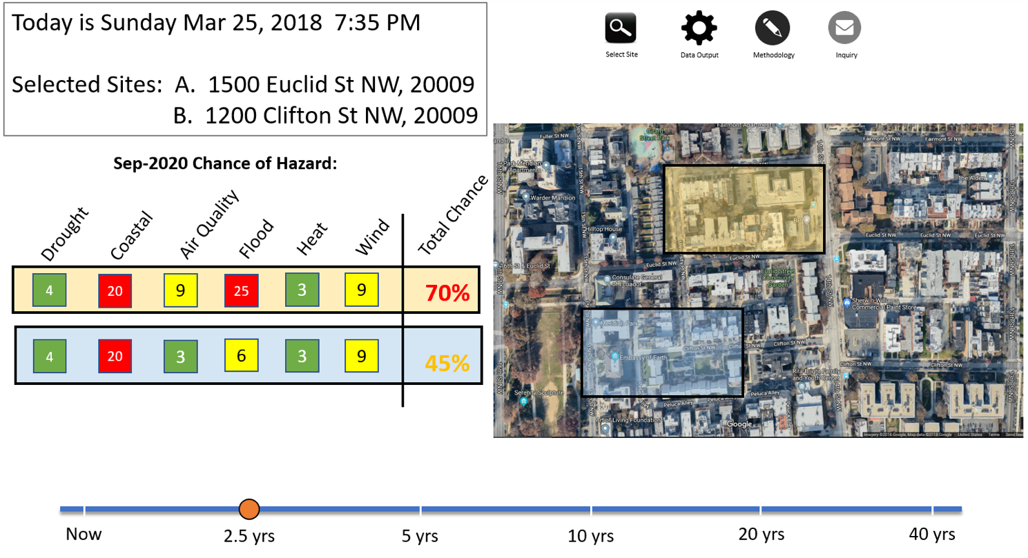
In addition, involved communities could help guide future directions in geoscience research. For example, we are working with decision makers to develop very simple ways to present probability of the events they care about by location. One early example, shown here, uses made-up numbers and locations to illustrate the concept and get feedback on the presentation of data.
We are continuing the effort to characterize decision-making in local communities, and to understand the types of information needed to inform adaptation strategies. We are also working with different user communities to identify and iteratively design new, localized presentations of current and projected climate change hazards. We welcome examples of unmet adaptation decision support needs, distinct and underserved user communities, and effective geoscience information for decision making. Please contact us at ([email protected]).