As Summers Bring Searing Heat, Cities Turn to Innovative Maps
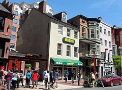
Urban heat islands trap heat, making neighborhoods like this one in Washington, D.C., even hotter on sizzling summer days. Photo by AgnosticPreachersKid, Wikimedia Commons.
By Anne Johnson
The heat of the summer is not just a nuisance but a significant public health threat. In most years, extreme heat causes more deaths than any other type of weather-related disaster. The danger is most acute for elderly people, who are more vulnerable to the effects of heat, and for people living in low-income areas, where cost barriers and features of the built environment make it harder to stay cool in hot weather.
As the mercury rises, temperatures vary substantially on the basis of proximity to trees or water, the density and nature of built structures, the heat output of air conditioners, and many other factors. Heat mapping is an innovative, data-driven method to visualize temperatures across a geographic area in order to understand why some areas get hotter than others on summer days.
By layering temperature data with demographic and socioeconomic information, heat maps can reveal the drivers that create risk spikes within a city. Three TEX projects are using heat mapping to help cities address different types of heat challenges.
“Many cities are interested in including extreme heat mitigation in their climate adaptation plans,” says Juan Declet-Barreto of the Union of Concerned Scientists and a scientific partner for a TEX project in Washington, D.C. “Detailed information on the people and places most sensitive to extreme heat can help prioritize resources, turning scientific data into straightforward, actionable information to help.”
The nation’s capital is essentially one enormous heat island, where the built environment causes temperatures to rise several degrees compared to the more forested areas just outside the city. It’s also a place where large low-income neighborhoods create pockets of heightened vulnerability to the health risks of extreme heat.
“These public health burdens cannot be overemphasized,” says Declet-Barreto. “We now know that across the world, vulnerability to extreme heat is mediated by socioeconomic status. Small-scale mapping helps us understand these inequities.”
Many underestimate the dangers of extreme heat, which causes more deaths than any other type of extreme weather. U.S. Air Force photo by Sue Sapp.
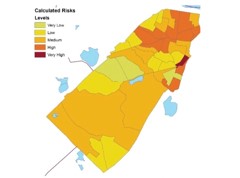
A TEX project in Brookline, Mass., also combined information about urban heat islands with demographic data. That exercise identified the elderly as a particularly vulnerable population within the city. The collaboration informed decisions about mitigation strategies such as increasing tree cover and designing cooling centers to give elderly residents a place of refuge on the hottest days.
The threat of extreme heat even reaches into historically chillier areas, such as Missoula, Mont. In addition to acute health threats of extreme heat, rising summer temperatures can wreak economic havoc by reducing tourism and increasing residents’ energy use and costs. In a new TEX project in Missoula, Mont., scientists and community members are working together to create heat maps and address priority areas for interventions such as urban forests.
Heat maps like this one of Brookline, Mass., help city officials identify vulnerable populations and prioritize mitigation strategies.
“We are just in the beginning stages,” notes Chase Jones, City of Missoula energy conservation and climate action coordinator, “but we believe this data will inform and enhance our growth policy, building codes, infrastructure plans and urban forest management.” The project extends and enhances Missoula’s Summer Smart program, a project to prepare community members for increased heat and wildfires in summer. The challenges associated with rising temperatures may be a little different in each place, but experience shows that heat mapping is a technique that can prove useful in almost any scenario.
“If you have the opportunity to inform policy and improve your community’s quality of life with science and data, jump on the opportunity,” Jones urges. “Unprecedented heat due to climate change is not going away, and preparing our communities to survive and thrive is something that shouldn’t wait.”
Dr. Dan Wildcat (of Haskell University) and Bull Bennett (of Kiksapa consulting) have been building their relationship with tribal colleges for years. Having worked on environmental issues for the past 20 years Dan Wildcat has…
Who We Are The Georgetown University Energy Prize is a long-term, goal- oriented initiative that calls for communities to come together and propose plans of action for continued energy saving. Community members with ideas relating…
[tabgroup tabs_title=”Overview”] [tabs tabs_title=”Overview” wrap=”yes” tabs_text=’ Who We Are The Pamir Mountains challenge seeks to generate ideas about how Earth science research and observations can help recalibrate traditional ecological calendars for a changing climate. On…
The Pittsburgh project team made significant progress toward their goal of developing a robust carbon inventory for the city and its Climate Action Plan. During the partnership’s first month, the team sat down with local…
The Hermosa Beach TEX project team had their first in-person meeting on August 25, 2016 in Hermosa Beach, CA. Lon Peters and community lead Kristy Morris discussed the project workplan , toured potential project sites, and…
Ajay Kalra and Marco Velotta continue to work together to assess drought risk and vulnerability in Las Vegas. Over the past weeks, the project team has obtained important information including model and climate data, which…
Leave a Reply
Stay Updated
Subscribe to receive the latest new and opportunities from the Thriving Earth Exchange.