Apply now to join our next cohort of Community Science Fellows and Community Leads!

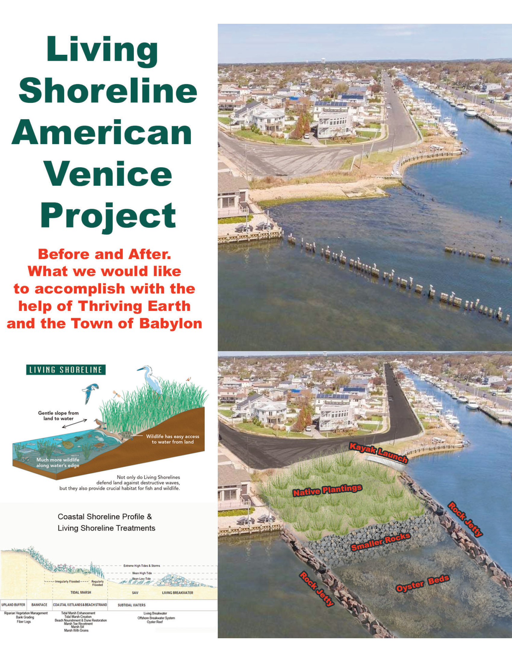
The American Venice team is working to design and implement a living shoreline at the mouth of the historic Grand Canal in the American Venice to help mitigate erosion and flooding and provide habitat and ecosystem services. The team hopes to co-develop the living shoreline and create an implementation and maintenance plan with scientists. Lastly, the team will create an accessible and interactive online community database where citizen scientists can play an active role in maintaining and monitoring the living shoreline.
29 October 2020 marked eight years since Superstorm Sandy made landfall near Brigantine, New Jersey. The storm affected every community along the New Jersey-New York coastline, but was especially damaging to low-lying coastal areas that were inundated by Sandy’s unprecedented storm surge[1]. A waterfront community within Lindenhurst, otherwise known as The American Venice, is a suburban community in the Town of Babylon on the South Shore of Long Island, New York. Created by the American Venice Corp in 1926 to mirror Venice, Italy, the town is characterized by a beautiful waterfront, complete with canals, and historic Venetian architecture such as the St. Mark’s Lions, famous bridges and traditional Italian villas. Due to the community’s unique history, the American Venice is currently being preserved as a National Historic District. Despite efforts for historic preservation and community revitalization, damage caused by Superstorm Sandy is ever present in the minds of community members. Although many homes have been rebuilt and elevated, American Venice has not seen the same recovery and resilience efforts as other parts of Long Island.
Long Island’s coastal communities are growing increasingly vulnerable to flooding and erosion. As the climate changes, these impacts are becoming more apparent and frequent. Sunny-day flooding, or an increase in water unrelated to a storm event, not only occurs during spring tide[2], but is increasingly coinciding with normal high tides. This flooding can disrupt traffic and cut off access to homes and other infrastructure. Not only does Long Island experience the effects of hurricanes, but on an annual basis is impacted by winter coastal storms (e.g., nor’easters) that can bring devastating impacts. It is imperative that coastal communities not only acknowledge their risk to such hazards but begin to plan mitigative actions that take into account predicted sea level rise (SLR)[3].
Long Island is composed of unconsolidated sediments such as cobbles and sand, which are subjected to natural coastal processes that move sediments around. This can result in erosion from one area and deposition in another. Coastal communities have been fighting against these natural processes in order to attempt to keep the sediment in place, which has historically led to engineered solutions such as bulkheads and dredging. However, most efforts are temporary and need to be maintained and eventually replaced. More recently innovative solutions have been explored that allow for hybrid or nature-based solutions. These structures, known as living shorelines, incorporate native elements to work with nature to protect built infrastructure. While other states have more experience with implementing these solutions, this is still an innovative technology on Long Island; utilizing this method could serve as an example for other communities to learn from.
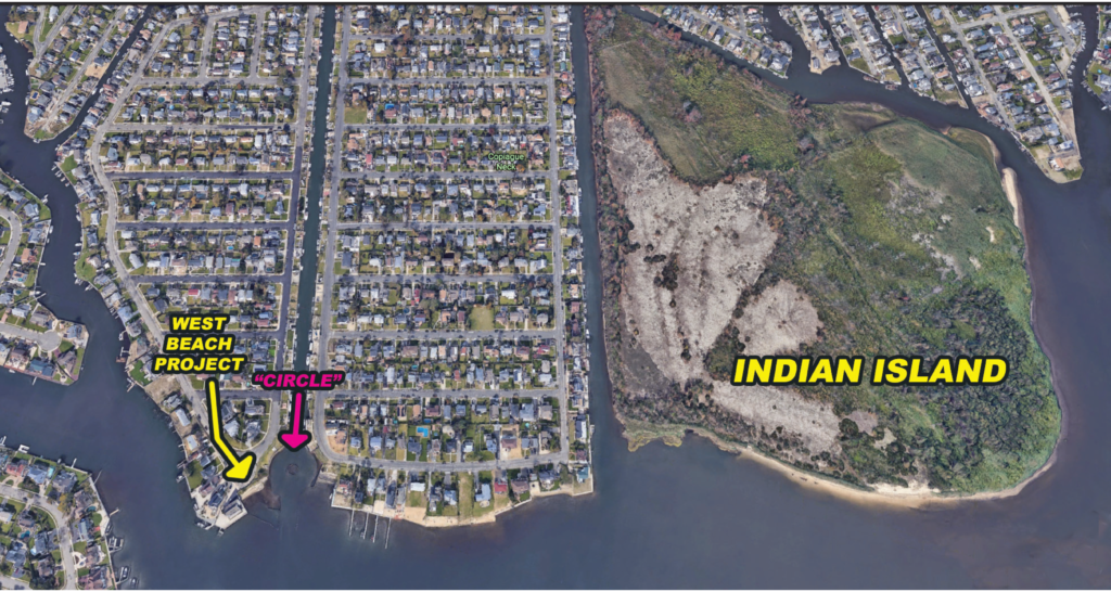
 The American Venice Civic Association, representing 1300 houses, aims to preserve and revitalize its community by focusing on historic and environmental restoration and resiliency measures. The Association has been fighting for recovery and coastal protection measures for nearly a decade and has identified the need for nature-based solutions to build community resilience and adapt to rising sea levels. The community is proposing a forward-thinking plan to transform an eroding beach at the mouth of the Grand Canal[4] into a Living Shoreline and preserve nearby Indian Island as a nursery and habitat sanctuary. The Living Shoreline will consist of wetland habitat serving as both flood protection and a nature preserve with an associated community monitoring initiative to maintain and protect the site after implementation. The associated preserve on Indian Island will serve as an incubation site to grow vegetation for the living shoreline and promote ecotourism via watersports and wildlife sightseeing. Community leaders have already gathered tremendous community support and buy-in. So far, the Town of Babylon has already taken the first step and removed all old bulkheads near the proposed site and has indicated commitment to further investment in coastal protection in the American Venice.
The American Venice Community Team sees flood mitigation, environmental protection, habitat restoration, environmental monitoring and community science as the main objectives for this Thriving Earth Exchange Project. Through these objectives the team hopes to build community resilience and unity. This project will both bring the community together by consciously educating and engaging community and school-age children, protecting the historic district and the waterways of the Great South Bay, as well as providing tangible benefits such as building credit towards the community rating system for the National Flood Insurance Plan (NFIP).
First, the group would like to develop a study centered around designing and building a Living Shoreline on the western corner of the mouth of the Grand Canal. The Team would like to work with an environmental engineer to join our Marine Coastal Processes and Hazards Specialist to help design the wetland, and then publish an implementation plan for the Living Shoreline. Following this, the Team will apply to a number of grants to supplement any of the Town’s financial assistance to help fund a community-built wetlands habitat. Specific outputs will include:
[1] Peak Superstorm Sandy storm surge of 7.73 feet measured at Great South Bay at Lindenhurst, NY
[2] Spring tides are exceptionally high tides that occur during the new and full moon, about twice a month.
[3] Estimated SLR in the Long Island Region by the 2050s could increase between 8-30 inches and by 2100, 15-72 inches.
[4] See photo for visual of beach location
Creating a living shoreline for community resilience: AGU’s Thriving Earth Exchange helps American Venice preserve and persevere amid changing conditions
Coastal communities along the Atlantic seaboard have experienced a range of hardships in the last two decades connected to routine and evermore destructive major weather events. The eight million residents of Long Island, extending 118 miles due east of New York City’s five boroughs, struggled after Superstorm Sandy destroyed upwards of 100,000 homes in 2012. In the aftermath, municipal authorities and property owners alike raised new and urgent questions about changing expectations for future events. How much higher could flood waters get? Could infrastructure be reliable for families fleeing inland or rescue crews pushing out towards the danger? Ultimately, what could it mean to live in a resilient coastal zone fated to increasingly more violent weather events but determined to thrive regardless?
Read the full story here.
Michele Insinga, Kathy Gullo and John Vogt will serve as the community leaders. The American Venice team is highly dedicated and engaged with the project, and thus will function as a collaborative team to contribute and meet project timelines.
(c) 2025 Thriving Earth Exchange