
Creating a conceptual model to inform coastal adaptation and flood protection strategy around a marsh-based wastewater treatment plant
Arcata, California, United States
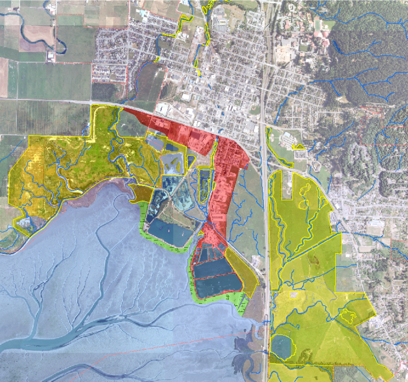
(Figure 1) Map of Arcata Bay showing highlighted restoration areas (in yellow), protection zones (red), and proposed new salt marsh living shoreline protection (green) around Arcata Marsh & Wildlife Sanctuary Recreational Area. Map from City of Arcata, Environmental Services.
This project addressed the City of Arcata’s priority to plan for sea level rise in Arcata Marsh. The city received scientific support working with Cal Poly Humboldt graduate student Maddie McNerthney, who is researching Saltmarsh Regression due to Sea Level Rise in Arcata Marsh for her Master’s thesis project. Maddie is now providing GIS support to the city and through this project was paired with a graduate research committee from University of Southern Mississippi to advise on marsh vegetation sampling and modeling to estimate sea level rise thresholds. Once complete, her research will benefit the community by increasing understanding of marsh dynamics under elevated water levels and the results will be communicated to key groups identified by the community leads, such as the Wetlands and Marsh Committee. The project resulted in a productive partnership made between the city government and research team.
Description
Arcata is located in northern California on the coast of rural Humboldt County along Arcata Bay estuary. Home to about 17,200 residents, including nearly 7,000 students at Humboldt State University (HSU), the coastal margins of the city were built on historically submerged area currently protected from inundation by dikes and levees. With rising sea levels, Arcata Bay’s shores are at risk to increasing impacts from flooding and higher than average tides.
The city government of Arcata recognizes the pending threats of sea level rise due to climate change. In particular, the city is considering adaptation strategies for the myriad public and private developments potentially affected. The city’s innovative marsh-based wastewater treatment plant is vulnerable due to its location (Figure 1) and is a critical priority for the city. Mitigating the impacts of increased flooding on homes and businesses in the South G Street corridor is also of great importance. Furthermore, preserving, and ultimately transitioning, ecological function and habitats in Arcata Marsh and Wildlife Sanctuary are primary adaptation objectives.
A Sea Level Rise Risk Assessment conducted in 2018 modeled sea level rise scenarios in the City’s Local Coastal Program (LCP) planning area. The modeling indicated the effects could be significant. While the South G Street area itself is an elevated structure created by historic fill, higher maximum tides will affect backwater flooding, groundwater elevation, and stormwater runoff rates. Even best-case modeled scenarios will require adaptation and accommodation.
Arcata residents have been engaged in the city’s adaptation planning efforts. Residents have participated in annual king tide monitoring and photo documentation events since 2017. The Friends of the Arcata Marsh, a local non-profit focused on education and outreach around the Arcata Marsh, provides tours, events, and education, some of which have been focused on sea level rise. The city has partnered with Humboldt State University on events. In addition, staff has held several stakeholder meetings, public forums, and study sessions with the Planning Commission and City Council on sea level rise. Arcatans are very engaged in the topic.
Living shorelines offer potential benefits for stabilizing sediment while maintaining shoreline migration capacity and preserving valuable habitat areas, and are one coastal protection strategy of high interest to the city. In the near term, building up hard structures like existing levees may provide sufficient protection around oxidation ponds. At some point, shifting toward nature-based living shorelines would provide co-benefits to preserve the salt marsh habitat and to dampen wave energy for flood protection. The City of Arcata is considering the merits of constructing living shoreline structures around the wastewater treatment plant oxidation ponds in tandem with building “eco-levees” (i.e. gradation between salt marsh/mudflats to upland), recognizing that this would be a temporary solution for shoreline erosion. Fully addressing the risks of rising ground and surface water from sea level rise will necessitate a measured retreat from former tideland areas in the long term.
The Project Plan
Arcata is striving to develop a well-researched plan for successfully executing shoreline protection measures between now and a higher sea level future. For this reason, Arcata seeks assistance in creating a conceptual model to visualize the salt marsh habitat in transition and identify tipping points at which to change adaptation strategy. A partner scientist should be able to synthesize existing information and recommend options to increase resilience and to inform the city’s coastal protection efforts over the next 5-10 years (short term), 10-25 years (mid-term), and 25-50+ years (long term).
An expert is requested to create a conceptual model showing the cross section of the salt marsh habitat on different time scales as erosion occurs, as living shorelines are built out, and as the marsh retreats landward. This work would build on an existing body of work done related to sedimentation, flood vulnerability mapping, hydrology and sea level rise scenario modeling in Humboldt and Arcata Bay for a more complete picture of how Arcata’s shorelines are changing and where the city government should target construction of stabilizing structures first. The work completed by the partner scientist should result in an accessible, well-visualized conceptual model that can be used for community outreach and engagement with data-driven recommendations to the Arcata government project team, and a brief written report for use by the project team.
Completing this work would benefit the overall Arcata community by enabling the city government to move forward confidently in strategically protecting eroding shoreline areas for stabilization, increasing the resilience of wastewater treatment infrastructure, homes, businesses, recreational areas and coastal habitats. It would also allow the city to more easily articulate the planned coastal adaptation strategy to a public audience, to set up permitting and remove barriers to compete for future funding opportunities.
The Project as it Happened
Major outputs of this project are a partnership made between the city and graduate student researcher plus academic committee, and ongoing research on Arcata Marsh. The research project direction and methodology has been informed by the city, including guidance on priority marsh shoreline areas to sample using drone imagery. Currently, the project is in a phase of data analysis and modeling. Preliminary results include a map of the site (I Street Marsh, below) and a vegetative habitat analysis, which found pickleweed (Salicornia pacifica) to be the dominant species. Collaboration between the research team and the city is expected to continue as results are finalized and shared with the public through presentations, a public-facing website, and a peer-reviewed publication.
Results from this project will also inform the city which sea level rise scenarios Arcata Marsh can tolerate, allowing decision makers to plan for coastal retreat or alternate solutions to adapt to climate change.
Secrets to Success and Lessons Learned
This partnership benefitted from matching a local university graduate student seeking a project topic with the community seeking scientific support. Maddie was connected with a research advisory committee, who provided technical guidance on the project. Both the researchers and the city benefitted from regular dialogue with one another by asking questions grounded in the needs of Arcata to inform project development. Because the committee members are based in coastal Mississippi and have research experience on Gulf of Mexico shorelines, the partnership resulted in knowledge sharing across regions.
For any similar projects matching a community with a graduate student as the volunteer scientist, it is recommended to have a plan in place for funding to support the student so they are able to devote sufficient time to the project. In this case, the student was employed by the city for GIS services. Future projects could include additional funding sources, such as a grant opportunity.
Timeline
The project should start by May 2021, meeting monthly as a project team over the course of roughly 12 months. The team will work to refine the outcomes and deliverables with the partner scientist, and then hold check-ins with the partner scientist about once each month throughout the duration of the work. The City of Arcata is eager to move forward in identifying the most feasible options for shoreline protection, to support planning efforts, review of funding sources, and applications for additional grants if necessary. Arcata’s draft Sea Level Rise Policy, LCP Plan and Wastewater Treatment Plan are currently being developed, and ideally, this project work would coincide with the LCP plan’s adoption by the city in mid-2021. Recommendations resulting from this work also have potential to shape the direction of steps toward implementation. The current project work would help leverage future grant funding by laying the groundwork for appropriate placement of stabilizing structures while supporting plans to scale up a living shorelines matrix for Arcata.
Project end date is anticipated in May 2023 with the conclusion of Maddie’s thesis program.
Project Team
Community Leads
David Loya, Community Development Director, City of Arcata
Susan Diehl McCarthy, Community Development Specialist, City of Arcata
Emily Benvie, Environmental Services Department, City of Arcata
Contributors
Mark Andre, Former Environmental Services Director
Netra Khatri, Engineering Division, City of Arcata
Jess Clifton, Engineering Division, City of Arcata
Jeff Anderson, Northern Hydrology Associates
Community Scientists
Maddie McNerthney, Cal Poly Humboldt Master’s student & City of Arcata GIS Technician
Dr. Patrick Biber, University of Southern Mississippi Gulf Coast Research Lab
Dr. Wei Wu, University of Southern Mississippi Gulf Coast Research Lab
Community Science Fellow
Morgan Corey, National Oceanic and Atmospheric Administration, National Marine Fisheries Service
Collaborating Organizations
City of Arcata
Cal Poly Humboldt (Humboldt State University)
University of Southern Mississippi – Gulf Coast Research Lab
Status:
Complete,
Location:
Arcata,
California,
United States,
Managing Organizations:
No organizations
Project Categories:
Climate Change,
Living Shorelines,
Project Tags:
No tags