
Identification of Pollutants in the Conodoguinet Creek Watershed: A Recommendation for Protection
Carlisle, Pennsylvania, United States
Local sources of pollution in the Conodoguinet Creek Watershed adversely affect surface and groundwater quality, posing risks to municipal and well-drinking water sources, locally caught fish, aquatic life, wildlife, biodiversity, and recreational activities such as fishing, swimming, and boating. This project aimed to establish a baseline by compiling and analyzing existing data, maps, and fieldwork to identify contamination sources and assess their potential impacts. A key objective was to inform the community about high-priority areas where pollution testing should be prioritized. The project also emphasized community education, engagement, and action. The final deliverable included recommendations for immediate actions and suggestions for continued monitoring, testing, and remediation.
Results
How was this study done?
To tackle these challenges, the project team developed the Creek Defenders Map and Pollution Report Form, designed to collect and analyze information to support the communities in the watershed.
The Creek Defenders Map integrates data from various sources, including USGS, EPA, citizen science initiatives, and scientific literature. It displays information on chemical sources, firsthand reports, water quality, and other environmental parameters. By consolidating this data, the map generates an interpretable “heat map” (as shown below) that highlights high-risk monitoring zones along the creek.

The Pollution Report Form empowers community members to report any pollution or environmental concerns they observe in their surroundings. It also allows users to submit multimedia evidence, such as photos or videos. Importantly, the system is designed so that new entries seamlessly integrate into the map, ensuring that the information remains current and relevant even after the project’s conclusion.
Challenges and Lessons Learned
While developing these tools, the project team encountered challenges related to data collection, including missing information, infrequent and sparse measurements, inconsistent formatting, and varying detection levels. A key takeaway from this project is that the absence of data does not imply the absence of pollution—a critical lesson that underscores the need for continuous monitoring and community engagement.
What did the project discover?
Major Chemicals of concern
PFAS
Per- and polyfluoroalkyl substances (PFAS) are a primary class of contaminants of concern due to their toxicity to humans and adverse effects on ecosystem health. Data from the Unregulated Contaminant Monitoring Rule (UCMR) 3 and 5 reveal frequent detections of legacy PFAS and perfluorinated short- and long-chain compounds, which are notoriously difficult to degrade. These pollutants have been detected at both the Carlisle Water Treatment Plant and the Shippensburg Borough Water Authority. In 2019, the US Geological Survey (USGS) reported the presence of PFBS, PFHpA, PFHxA, PFOS, and PFPeA near Hagerstown, PA, an area further east characterized by built land use.
PCBs
Polychlorinated biphenyls (PCBs), another class of toxic and persistent organic pollutants, have been detected in sediment, tissue, and water samples collected by the USGS. The Environmental Protection Agency (EPA) has identified two point sources of PCB contamination in the watershed. The first is the Navy Ships Parts Control Center, which is associated with PCBs and other contaminants. The second is the Letterkenny Army Depot, which is also linked to PCBs and additional hazardous substances.
PAHs
Polycyclic aromatic hydrocarbons (PAHs), which are present in coal, crude oil, and gasoline, can be released from these sources and other fossil fuel-based products. These compounds enter the atmosphere during the combustion of fossil fuels and organic matter. A 2010 study conducted throughout the Conodoguinet Creek watershed identified high concentrations of PAHs along the stream, particularly in areas with high industrial activity. In the western, more rural part of the watershed, elevated PAH loads were likely attributed to a local gas station leak. Additionally, high PAH concentrations were observed near Carlisle and in the far eastern portion of the watershed, closer to Harrisburg, in more urban settings.
Recommendations on where to test?
Based on the Creek Defenders Map, the project team outlined a four-phase plan for testing and monitoring the Conodoguinet Creek, as described below. A spatial distribution of the proposed phases is also shown in the map (screenshot included below). These phases were developed considering the outcomes of scientific research, although any socio-economic constraints (such as the availability of funds to prioritize one area over another) would require community input and adaptation.
LeTort Creek, located in the lower Conodoguinet Creek watershed, is recommended as the highest priority for initial testing. This recommendation is driven by several factors:
- The presence of majority environmental justice communities.
- Diverse land cover types, including agricultural land, tree cover, and urban areas.
- Proximity to potential PFAS industrial sources, such as Carlisle Barracks, a printing facility, and a metal coating facility.
Focusing initial testing efforts on LeTort Creek would help establish a baseline understanding of contamination risks while addressing environmental justice concerns in the watershed.
Overall, the four phases are as follows:
Phase 1 (blue) – Initial priority sites along LeTort Creek.
Phase 2 (red) – Sites to monitor directly along the Conodoguinet Creek to gauge overall health and state of contamination (microplastics, PFAS, PAHs, POPs). These include wastewater effluent.
Phase 3 (purple) – Follow-up sites (secondary tributaries) to monitor include Trindle Spring Run and others (based on phase 1 results)
Phase 4 (green) – Follow-up sites (secondary tributaries) to monitor include LeTort Creek, Trindle Spring Run, and others (based on phase 1 results)

Community Engagement
Throughout this project, the project team conducted multiple outreach events to educate community members about potential chemical pollutants and their associated health risks. As new information became available, they ensured timely communication with the community. Recordings of these events can be accessed on the community lead’s YouTube channel, managed by Tamela Trussell (YouTube Channel Link).
The Creek Defender Pollution Report Form was developed to facilitate ongoing community involvement. It is an online tool that allows community members to report pollution and incidents involving diseased or dead wildlife. This platform documents pollution data not only in the Conodoguinet Creek watershed but also in any watershed across the United States. The form includes fields for pollutant type, location, comments, and multimedia uploads (such as photos).
Additionally, the project team introduced The Creek Snapshot, a digital photo journal designed to share posts, photos, links, and files related to the Conodoguinet Creek watershed. This platform covers a variety of topics, including nature observations, pollution updates, and community events, fostering ongoing engagement and awareness.
The project team also presented the findings of our project at the recently concluded Annual Meeting of the American Geophysical Union in December 2024.

Description
About the Community
The Conodoguinet Creek stretches 104.5 miles from the Kittatinny Ridge, winding through the Cumberland Valley, and eventually merging with the Susquehanna River near Harrisburg. It traverses Franklin and Cumberland counties from east to west and touches parts of Dauphin County. Encompassing a 524-square-mile watershed, the area includes 40 municipalities, with the majority falling within Cumberland County—Pennsylvania’s fastest-growing county. The watershed is home to prominent institutions such as Dickinson College, Shippensburg University, the Army War College, and the Naval Support Activity in Mechanicsburg. It also boasts two world-renowned limestone trout fishing streams: Yellow Breeches and LeTort Creek. The Conodoguinet Creek Watershed provides essential drinking water and recreational opportunities for approximately 64,980 residents.
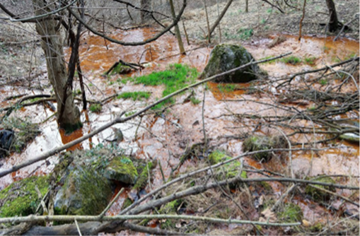
Historically, the region was predominantly rural and agricultural before 2000. However, in the years since, extensive farmland has given way to suburban development, including housing, warehouses, and big-box stores. This rapid development has introduced significant challenges, particularly through intense stormwater runoff that carries pollutants and sediment into the creek. In addition to nonpoint source pollution from impervious surfaces, the watershed faces potential point source pollution from several manufacturing facilities that use hazardous substances such as per- and polyfluoroalkyl substances (PFAS) and polychlorinated biphenyls (PCBs).
The Conodoguinet Creek Watershed provides vital ecosystem services to the community, supporting numerous streams classified as warm and cold water fisheries. However, the watershed faces growing pressure from rapid development and contamination. Despite the increasing industrial and human footprint, the cumulative impact of pollution on the watershed remains largely unknown to the community. This study aimed to address that knowledge gap by identifying potential sources of contamination and highlighting priority areas where pollution testing should be conducted.
The Project as it was Planned
A report will provide an analysis and a conclusion recommending further monitoring, testing, and remediation. Known and potential point and non-point source contamination with and without current toxicity data will be identified. It will include abiotic and biotic data, charts, graphs, and maps. Known data will include chemical and biotic type, testing dates, locations, and amounts.
The recommendations will also include wastewater discharge and treatment by both industry and municipality, drinking water treatment by the municipality and third-party providers, restrictions on landfill leachate land application of biosolids if contaminated with PFAS, remediation by military base if contaminated, and measures that homeowners could take like installing filters on faucets used for drinking and cooking.
These recommendations will be shared with the municipalities in the Conodoguinet watershed’s local and county government, NGOs, colleges/universities, scientists, businesses, farmers, and residents. The information will help drive further education, research, science, and policies to minimize and clean up contamination. The recommendations will also be used to apply for grants to further educate, research, and prevent and remediate contaminated areas to improve the watershed’s health and the local community’s health. Community education, engagement, and action will be emphasized throughout the project.
- Activities
- Gather and analyze initial data
- Literature review (including UCMR 5 occurrence data)
- Interview local/related NGOs and foundations
- Analyze this information to determine what additional data would be helpful
- Use conclusions to advocate and drive policy, behavior changes, and further research
- Gather and analyze initial data
- Outputs
- Comprehensive written report with recommendations for further monitoring, testing, and remediations
- 1-pager Infographic
- Letters to impacted government agencies, NGOs, Conodoguinet Creek Watershed academic and municipalities land use sustainability planning departments.
- Press release
- Op-eds will be written and submitted to local and state newspapers, Bay Journal, PA Environment Digest Blog, and the Stream of Consciousness. etc.
- Website
- Outcomes
- The community, watershed organizations, NGOs, educational institutions, governing leaders, and regulatory bodies will have access to the current known PFAS and other hazardous chemical contaminants, microplastic contamination, and tangible recommendations for further monitoring, testing, and remediation.
- Impacts
- The local community will be better informed about human and environmental harms and will have more tools and power to address contamination and exposure.
- Scientists will know where there are holes in the data and where to dedicate further research.
- Other communities will have a model to follow
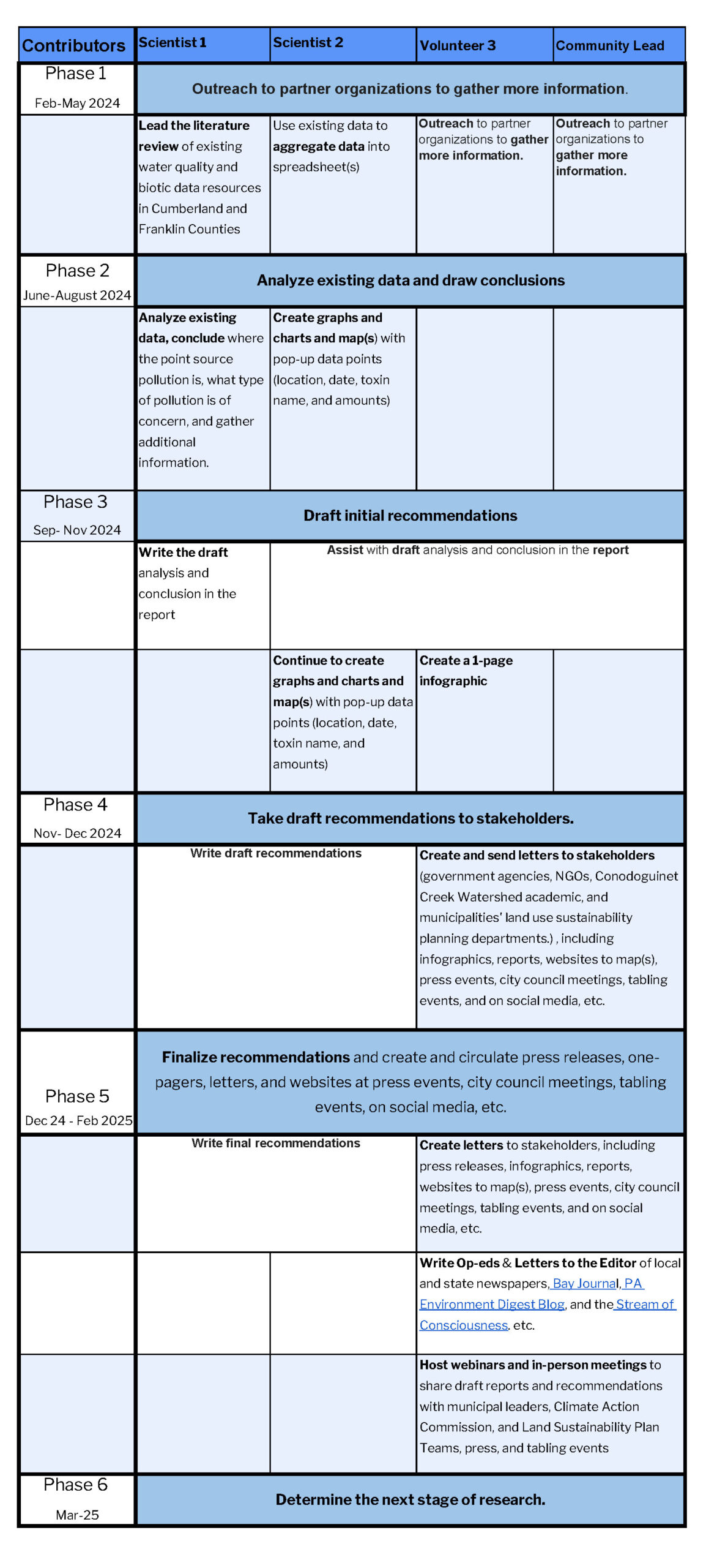
Timeline and Milestones (see also table below)
February – March 2024: Recruit Community Scientists and revise scope if needed.
March – June 2024: Initial literature review. Outreach to partner organizations to gather more information.
June – September 2024: Analyze existing data, draw conclusions on where point source pollution is, what type of pollution of concern, and gather additional information.
October – December 2024: Draft initial recommendations.
December 2024 – January 2025: Take draft recommendations to stakeholders.
February – March 2025: Finalize recommendations and create and circulate press releases, one-pagers, letters, and websites at press events, city council meetings, tabling events, on social media, etc.
April 2025: Determine the next stage of research.
View Timelines and Milestones Chart Here
Timeline and Milestones (with specific roles and responsibilities)
Project Team
Community Leads

Tamela Trussell. Tamela is the founder of Move Past Plastic (MPP) and TLC Education, a Climate Reality Leader, a Master Watershed Steward, a committee member of the Carlisle Climate Action Commission, and a board member of the Conodoguinet Creek Watershed Association.
Community Science Fellow

Shashank Anand is a postdoctoral research scholar in the Department of Biological and Agricultural Engineering at Texas A&M University. His primary focus involves enhancing the modeling approach for organic carbon dynamics under various land management practices and shifting climatic conditions. Shashank earned his Ph.D. from Princeton University in 2023.
Community Scientists

Chiara Smorada is a graduate student in Princeton University’s Civil and Environmental Engineering Department. Her current research focuses on the biological degradation of per- and polyfluoroalkyl substances (PFAS) in soil and river water. She studies microbial community shifts in PFAS-impacted sediment and investigates enzymes that may play a role in PFAS defluorination. She looks forward to sharing her knowledge about PFAS to empower others to engage in environmental stewardship.

Marissa Kulkarni is a Geospatial Specialist located in Santa Clara, California. She has deep experience with geospatial analysis, including remote sensing, spatial statistics, cartography, and ArcGIS software. Currently, she’s mapping utility-scale solar, wind, battery storage, and hydrogen energy facilities at RWE Clean Energy. As a Pennsylvania native and passionate environmentalist, she looks forward to supporting healthy, plastic-free waterways across the Conodoguinet Creek watersheds.
Astrid Lozano-Acosta is a science educator interested in inquiry-based learning and hands-on STEAM activities, with experience developing bilingual didactic materials. She has also performed data analysis of aerosol and groundwater information and volunteered with grassroots environmental organizations by providing scientific summaries, maps, and infographics.”
Status:
Complete,
Location:
Carlisle,
Pennsylvania,
United States,
Managing Organizations:
Anthropocene Alliance,
Project Categories:
Contamination/pollution,
Natural Hazards,
Natural Resources,
Water Quality,
Project Tags:
No tags