
Increasing community resilience for watershed urbanization
Hopkins, South Carolina, United States
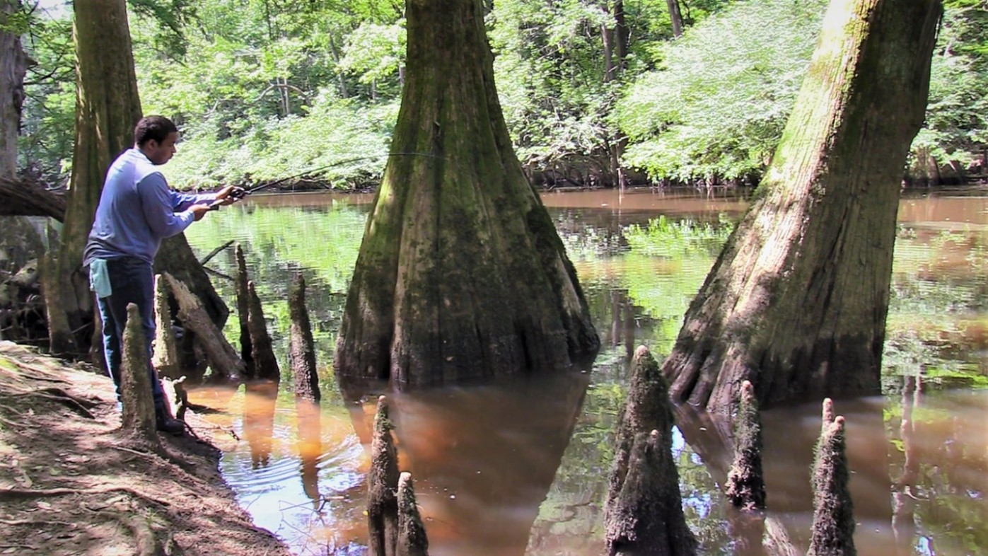
Quenten Masters, 2021 Fishing Management and Engagement Intern, monitoring and cataloging fish species in Cedar Creek at Congaree National Park. Cedar Creek, a regional paddling destination, drains approximately 68 square miles of lower Richland County and faces significant development pressure. Photo by Claudia C. Santiago.
This project seeks to leverage a community-level and interdisciplinary approach to water quality monitoring that engages local decision-makers, resource users, community members, and scientists. The South East Rural Community Outreach (SERCO), Congaree National Park (represented by Community Science Fellow and biological science technician Claudia Santiago), and other local community leaders will facilitate a five-phase plan. The project will establish a water quality monitoring protocol based on the South Carolina (SC) Adopt-A-Stream methodology but modified to better assess the local, swampy stream geomorphology. Academic experts in low-gradient, low-energy, fine-sediment, Coastal Plain blackwater stream systems will inform the redesigned protocol. Practical folklore knowledge from the local African American community and other historically excluded communities will align the initiative with local cultures and help establish its relevance. The community leads will engage local community members and partners to communicate water quality monitoring results and topics.
Description
Key Words
Urbanization: the process through which municipalities grow and the percentage of the population that moves to live in municipalities increases
Coastal plain: a flat, low-lying piece of land next to the ocean
Water quality monitoring: activities to evaluate the physical, chemical, and biological character of water concerning human health, ecological conditions, and designated water uses
Nitrification: process by which ammonia is converted to nitrites (NO2-) and then nitrates (NO3-). In agricultural systems, where fertilizer is applied as ammonia, conversion of ammonia to nitrate increases the number of nitrates that leak downward in the soil and can degrade water quality
Stream geomorphology: study of the changes in geology or land features of a stream over time
Community resilience: the continuous capability of a community to use available resources to respond to, withstand, and recover from adverse situations.
The Community
Richland County is constructing a regional sewer system that will significantly increase urban development pressures in the local watersheds around and within Congaree National Park (CONG). The Lower Richland Sewer System (LRSS) project is intended to connect failing septic systems with more reliable regional wastewater treatment infrastructure and eliminate several wastewater facilities that are not meeting SC Department of Health and Environmental Control (SCDHEC) regulations. Additionally, it may help reduce the amounts of fecal coliform, heavy metal, and pharmaceutical contamination found in Cedar Creek and other streams within CONG. While the new sewer system can address most of these issues, it also unintentionally supports an increase in commercial, industrial, and residential development along with socio-economic and gentrification concerns. The draft engineering plan for the LRSS project does not consider urban expansion in Lower Richland. Urbanization, however, could alter water quality by introducing new pollution sources, increasing the sediment load carried by streams, decreasing groundwater recharge, promoting eutrophication, and causing temperature variation in streams.
SERCO and local community leaders have initiated proactive engagement sessions to listen to the community’s concerns. Residents expressed that they cannot afford tap-on fees plus a monthly bill, and they do not need the service. In addition, residents are worried about potential health issues caused by malfunctioning sewer pumping stations in flood-prone areas. Gentrification and increased traffic are two core worries connected to a history of concern about displacement from their property, a changing landscape, and loss of rural “character.” The area has a long, complex, and rich culture that spans thousands of years, including the Mississippian paramount chiefdom of Cofitachequi, European colonial development, Antebellum slavery at several local plantations, and a powerful Reconstruction-era legacy that included baptisms in Cedar Creek. Freshwater fishing in the local creeks has been a long-standing tradition, and in many cases is still a potentially supplemental food source for residents.
The concerns of CONG are similarly complex and long-standing. An agricultural legacy and poorly maintained septic systems across Lower Richland have contributed to contaminants of emerging concern, specifically pharmaceuticals, agricultural chemicals, and fecal coliform bacteria. The presence of chemicals and pathogens threatens the biological activity of aquatic ecosystems in the waterways of CONG. Particularly, pathogens such as fecal coliform bacteria may cause serious illnesses in humans including various gastrointestinal (GI) illnesses. This has the potential to impact visitor experience, appeal, and spending at the park; approximately 150,000 visitors spend $8 million per year to visit the park to hike, camp, paddle, and fish.
The Project
We seek to develop and implement a modified citizen science water quality and geomorphology monitoring protocol. Community members will implement the protocol to collect baseline data that will help track how urbanization and pollution impact local surface waters. At CONG water quality is a major concern for fisheries and paddling. Evaluating a healthy watershed requires an understanding of landscape condition, habitat, hydrology, geomorphology, water quality, biological condition, and vulnerability. Chemical and biological monitoring are effective to monitor the stream health but require potentially expensive sensors and supplies as well as expertise. Stream geomorphology, on the other hand, provides an accessible, visual metric that is—if calibrated correctly—very amenable to citizen science monitoring. Stream geomorphology reflects how water, sediment, and organic matter balance with slope and width, surficial geology, soils, and vegetation to determine a river channel’s form. Human disturbances such as urbanization, erosion, pollution, and land use can cause a stream channel to change its pattern, profile, and dimensions. These changes can further impact habitat quality, threats to public safety, and other ecological parameters.
Continued monitoring at various sites can serve as a benchmark for development impacts, community action needs, and management/restoration goals. Additionally, monitoring program results could encourage actions to improve water quality, support healthy freshwater fishing, facilitate further research and monitoring, and reduce potential public health risks at CONG. The project aims to frame the monitoring protocol by leveraging practical folklore knowledge of the African American community and other historically excluded communities that have long resided in the area. SERCO, CONG Community Science Fellow Claudia Santiago, and other partners will facilitate a five-phase project consisting of the following activities:
- Phase I involves recruiting academic and professional partnersinterested in community engagement about local stream geomorphology. The streams found near CONG and Lower Richland are extremely low gradient blackwater streams and different from typical “Piedmont streams,” used as reference sites by SC Adopt-A-Stream. These differences have a significant bearing on the collection, analysis, interpretation, and monitoring of data. The purpose of this phase is to bring in scientific experts to help re-calibrate the reference models used for physical stream monitoring data collected by community science.
- Phase II involves facilitating knowledge exchange and promoting local group learning about water quality and sustainability through workshops. Dialogue between scientists and community memberswill frame and tailor multiple forms of scientific and expert knowledge to the specific context. The sessions could provide an understanding of how different community members perceive water quality issues.
- Phase III involves coordinating a partner-led symposium of one or more days that focuses on the science of coastal plain stream geomorphology and establishinga water quality monitoring protocol. The water quality monitoring program will be based on the SC Adopt-A-Stream methodology, but the final protocol will be informed by the symposium and workshops. This phase will involve recruiting community members, selecting sites, developing training, and coordinating data.
- Phase IV involves engagingdiverse (ideally intergenerational) field teams from Lower Richland to collect data.
- Phase V involvesrecruiting local community members to communicate water quality monitoring results through filmmaking.
Timeline and Milestones
Phases are subject to change
Phase I: November 2021- February 2022
Phase II: March 2022 – May 2022
Phase III: July 2022 – September 2022
Phase IV: October 2022- December 2022
Phase V: January 2023-March 2023
Project Team
Community Leads
Dr. Tameria M. Warren is the undergraduate studies coordinator for the School of the Earth, Ocean, and Environment (SEOE) at the University of South Carolina. She is also a member of SERCO, which is a community partner for the project. Dr. Warren is interested in increasing environmental awareness and engagement in the Lower Richland community, the home of the Congaree National Park and portions of the Congaree Biosphere Region.
Marie Barber Adams is the chair of SERCO and a retired educator whose family has been landowners in the Lower Richland area since 1872. SERCO is a non-profit organization focuses on historic preservation, conservation, and enhancing communities within the Lower Richland Heritage Corridor. SERCO continually strives to create partnerships within the Lower Richland area to provide charitable, educational, enrichment, and scientific programs to strengthen and expand the capacity of the community for a better quality of life for its residents.
Community Science Fellow
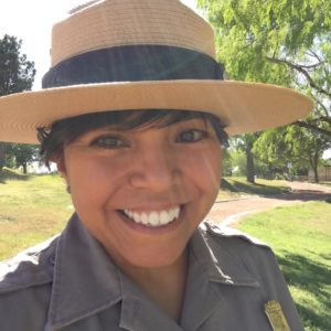
Claudia Santiago is a Biological Science Technician and Citizen Science Coordinator at Congaree National Park. She has worked with the interpretative program at Chamizal National Memorial, Gila Cliff Dwellings National Monument, and Washita Battlefield National Historic Site. As a geoscientist and interpreter, Claudia is enthusiastic about creating inclusive spaces that connect scientists and non-scientists and ensuring that underrepresented communities access science and public lands.
Status:
Complete,
Location:
Hopkins,
South Carolina,
United States,
Managing Organizations:
National Park Service,
Thriving Earth Exchange,
Project Categories:
Contamination/pollution,
Natural Resources,
Project Tags:
No tags