
Mapping & Attribution of Flood Exposure and its Health Consequences in the Pee Dee River Basin
Marion County & Rosewood, South Carolina, United States
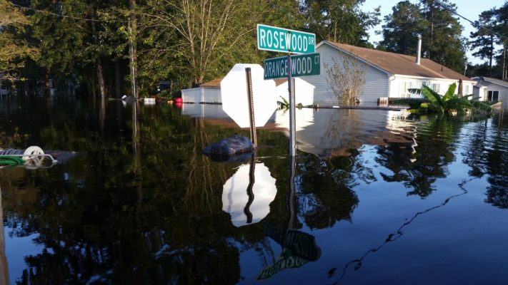
Photo courtesy of Terri Straka
Over the past 5 years, residents of Horry County and Marion County have been flooded on an increasingly regular basis, despite no history of severe flooding before 2015. While some floods were associated with tropical storms making landfall, other flood events have occurred on clear-sky days without advance warning or attribution of their causes. Our goal is to develop an interactive map that provides communities with clear information about each of the recent floods in the context of historical land-use change by combining satellite-derived layers with community-sourced, in-person observations. The map will also incorporate soil & groundwater testing to help quantify the health impacts of these floods, and include the locations and access information for water level data from river gauges. This effort will equip community members to both anticipate oncoming floods and to take evidence-backed action to mitigate the causes and consequences of these floods.
Description
This project is a collaboration between two communities located 100 miles apart in the Pee Dee river basin that have both experienced unprecedented flooding over the past 6 years. Rosewood Estates is a community located along the Intracoastal Waterway in Socastee (an unincorporated part of Horry County), just north of the convergence of the Waccamaw and Pee Dee rivers. While Horry County is generally known to be an affluent and politically powerful region of South Carolina, decision-making power and allocation of resources within the county is dominated by the Myrtle Beach area, leaving unincorporated parts of the county without a voice in local issues. Marion County is a small inland county nestled between the Great and Little Pee Dee rivers, just upstream of Horry County. Located in the “Corridor of Shame”, Marion County’s public services have been woefully underfunded for decades, and many residents rightly feel that the state has effectively written them off.
[caption id="attachment_26124" align="alignright" width="400"]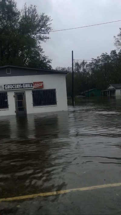 Photo courtesy of Virginia Singleton Sanders[/caption]
Since 2015, both of these areas have been subject to increasingly regular flooding events, despite no prior history of severe flooding. Some floods have been associated with named storms making landfall (i.e. Hurricanes Matthew & Florence), while other floods have occurred without warning on clear days. Members of both communities believe that many of the floods, particularly those occurring on clear days without an obvious weather-related cause, are due to large water releases from dams upstream, such as the Narrows Dam on Badin Lake and the Blewett Falls Hydro Power Station managed by Duke Energy. When questioned on the subject, Duke’s spokespeople have emphasized that the Blewett Falls dam is not intended for water management and that if a storm raises the volume of water entering the lake they have to release an equal volume downstream. This is not perceived as a satisfactory resolution for the clear-sky flooding events, which have occurred without warning (often at night) and are described as “coming at you like the ocean tide” and “rising inches per second” by community members. The floodwater, observed to be full of animal waste and hazardous chemicals, has contaminated the landscape, and community members are permanently unable to grow food or graze livestock in previously flooded fields. Private groundwater wells have become undrinkable, people have developed fungal infections and various other health complications related to the poisoning of their soil and structural rot of their buildings, and one member of the community attributes the repeated stress of constant flooding and rebuilding as a major cause of his parents’ passing. The idea of dredging the river has been raised in both communities, and though it faces resistance from conservation groups, members of Marion County emphasize that they’ve watched the Great Pee Dee river get substantially shallower over their lifetimes, with places that were once local swimming holes now able to be easily walked across due to buildup of debris and sediment. (They requested that the Army Corps of Engineers dredge the river, but the Corps turned them down). Thus far, the most tangible governmental action taken in response to the floods has been the buyout of some homes in the Rosewood Estates community. The ongoing buyout process has been a good solution for community members who are willing to relocate and able to get their applications approved, but the buyouts are often not reflective of the full value of the house and seen as a bad solution by some people who have lived there for decades and never had flooding issues prior to 2015. Some buyouts have been offered to Marion County folks, but most have deep ancestral ties to the land and aren’t prepared to abandon the place they have farmed their whole lives. In response to pressure from flooded residents of Rosewood, South Carolina established a “Floodwater Commision” to study the issue – they are perceived by community leaders as a largely useless political entity with some good members who advocate for badly impacted areas and at least helped get the ball rolling. The commission has released one report which garnered a good deal of backlash for advocating that naturally flood-resilient wetlands be paved over for new developments, while the rivers are channelized and new lakes are dug to absorb excess water in a poor facsimile of the natural protection offered by the wetlands. It is quite possible that this recommendation would actually worsen flooding for everyone. South Carolina has also instituted a new Resiliency Office, which is just getting off the ground, and there is some hope that this office can be persuaded to hear directly from the impacted people in Marion and Horry counties.
The Project
The sudden onset of repeated flooding in the Pee Dee River Basin in 2015 is evidently due to a complex combination of factors, most notably increased rainfall in the watershed (which may be related to ocean warming), reduction in the capacity of the river itself, water management practices upstream, and land-use changes (particularly deforestation and paving over wetlands). The effects of polluted floodwater on the health of people and their land have also not been measured or accounted for in any way. Rigorous attribution of the causes of these floods and quantification of their toxic impacts is critical to the communities’ ability to respond effectively to the existential danger they pose. Our goal for this project is to provide the people in harm’s way with a clear science-backed picture of both the driving factors and the major health consequences of these floods, laying the groundwork for future advocacy geared towards the most impactful solutions. We plan to develop an interactive map that combines satellite-derived analysis of land-use change and flood risk over the past several decades with community-sourced data, photos, videos, and personal accounts of each of the major floods that have occurred since 2015. By tying local documentation of the events in two different communities together with broader spatiotemporal risk analysis, we hope to demonstrate both the severity of the issue and the breadth of its effects. Creation of the map will also incorporate soil/groundwater testing (and other quantification of health outcomes as is possible), which has been severely lacking given the evident toxicity of the flooded land long after the water has receded. Finally, the map will include the locations of river gauges and access information for real-time water level data, so that it can be of use in the event of oncoming flooding. This will also help identify locations where additional gauges would be of most use to the communities. One of the first issues we intend this project to remedy is the occurence of floods without any warning. As long as the drivers of these clear-sky, zero-warning flood events remain unclear, it is difficult to design an effective early-warning system. Our analysis will reduce that uncertainty, and empower our community leaders to demand action from those in a position to implement the most effective early warning protocol. This could involve a negotiation with Duke Energy to forewarn everyone downstream when they will be releasing water, it could involve a collaboration with the USGS to install network-attached river gauges that send an alert when the water level rises too quickly, it could be a collaboration with meteorological forecasting groups to identify when rainfall in the basin is projected to greatly exceed its river capacity – the point is that we don’t yet know what will be most helpful, and our analysis is intended to remedy that issue. Depending on the results of this project, there could be a second phase focused on the development of an early warning system. Early warning is important and can save lives, but it is critical to understand that flooding is a very new development in the history of these communities, and our project must also empower people with the information they need to demand change. Clear allocation of the sources and distribution of flooding risk, along with demonstration of the health consequences of further inaction, will aid communities in both identifying the changes they need and then lobbying for them at the county and state levels. Based on the results of our analysis, these changes might include – for example – dredging, dikes, buyouts, agreements with dam managers, moratoriums on wetland development, and more.
Timeline and Milestones
- The project is envisioned to take 12-18 months in total.
- Candidates will be interviewed in October 2021 and the project will begin immediately after selection.
- A relevant date to keep in mind is that Horry County will be adopting new FEMA flood zone maps on December 16, 2021.
Project Team
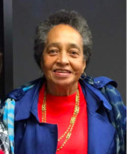 I am Virginia Singleton Sanders the mother of two children, eight grandchildren and nine great-Grandchildren. I am a native of South Carolina but left to attend college in North Carolina. My husband was a career military soldier so we spent thirteen years in Europe and lived in six states in the United States. Upon my husband’s retirement we returned to South Carolina and now reside in the Lower Richland community in Columbia, SC which I call “a diamond in the rough”. I served seven years on the Richland County Conservation Commission and five years of the Transportation Oversight Commission. I am currently working on the Healthy Community Campaign for the National Sierra Club in Marion County and Richland County South Carolina which are both Environmental Justice communities. The first initiative I worked on for the Sierra Club was to stop a two thousand acre Technology Park and Gated residential development on a floodplain that would have diverted the water toward a low income Environmental Justice Black community. It took five years of educating the public and fighting politicians and developers, but the community came together and we defeated them. Five years ago I organized bus riders in the city of Columbia to pass a penny tax initiative to improve Public Transportation as well as invest in walking and bicycle trails. After the initiative passed I helped the bus riders form an association. I am also currently working with the Thriving Earth Exchange to Stop the Nuclear Regulatory Commission from awarding a forty year permit to the Westinghouse Fuel Fabrication Plant located in the Lower Richland Community.
 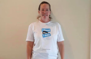 Terri Straka is a resident of the Rosewood Estates community in Socastee, Horry County, South Carolina. She is a founder of Rosewood Strong, a group of residents living in Rosewood, who were flooded during Hurricane Florence and have continued to be impacted by repetitive flooding. After seeing that the authorities weren’t doing anything, they came together to advocate for themselves to get justice and support. Terri has been fiercely advocating to the local officials to act on this issue, even leading a rally last year outside the offices of local government. Due to her leadership, Horry County applied for federal grants and received $15.6 million for flood mitigation activities, with $13 million going to fairly compensating and relocating repetitve flood victims in Socastee. She has continued to be a leader in raising awareness of the impacts of industrial and housing development as well as the Duke Energy Dam on exacerbating flooding as well as advocating for flooding solutions and infrastructure.
Community Scientists
Scott Curtis, Ph.D., is the Director of the James B. Near Center for Climate Studies at The Citadel in Charleston, SC. He is also the Dr. John Lining Professor of Physics. He holds a B.A. in Environmental Sciences from the University of Virginia and a M.S. and Ph.D. in Atmospheric & Oceanic Sciences from the University of Wisconsin-Madison. Related to the present study, Scott has investigated compound flood events in rural eastern North Carolina. With his team of researchers, he has employed mixed-methods approaches: determining historical risk with high-resolution inundation models and satellite data, and assessing risk perception, metrics of economic and health care impacts, and mitigation strategies with hazard professionals (planners, emergency managers, etc.). Scott enjoys biking and kayaking.
John Reinfelder is Professor of Environmental Sciences in the School of Environmental and Biological Sciences at Rutgers University. His research interests include the sources, transformations, bioaccumulation and trophic transfer of mercury and other trace elements in aquatic ecosystems, contamination of surface and groundwater, microbial ecology, acid mine drainage, and contaminant accumulation in rice. John received a B.A. in Biology from Johns Hopkins University and a Ph.D. in Oceanography from Stony Brook University. He joined the Rutgers faculty in 1996 where he teaches environmental chemistry and aquatic chemistry.
Community Science Fellow
 Carson Witte is a 4th-year PhD student at Columbia University, studying Air-Sea Interaction under the mentorship of Christopher Zappa. He holds a B.A. in Physics & Engineering from Pomona College and a M.A. and M.Phil. in Ocean & Climate Physics from Columbia University. He has spent the past several years working on Ikaaġvik Sikukun, a knowledge co-production project conducted in partnership with Indigenous Elders in the Alaskan village of Kotzebue. He is interested in using observational techniques in pursuit of community-led goals, bridging the scales of direct observation to wider spatiotemporal domains, and constantly asking questions of the cultural context in which scientific research is conducted and results interpreted. Carson also enjoys pretty much all types of outdoor recreation, is passionate about music, and loves to cook.
Partners
 Sheelah Bearfoot is a program manager at Anthropocene Alliance. She graduated with a degree in Genetics and Plant Biology from UC Berkeley in 2016. She’s Chiricahua Apache, and worked at the Native American Health Center in SF for two years as a diabetes educator before starting a master’s in Environmental Health Science at Hopkins, where she continued her focus on Indigenous health disparities.
  Alexis Hidalgo is a Program Manager for Anthropocene Alliance, the nation’s largest coalition of frontline communities fighting for climate and environmental justice, of which Virginia’s and Terri’s communities are both a part. She hopes to support in any way possible the incredible work that they are doing to merge science and advocacy in their communities.
Collaborating Organizations
![]() Founded on July 1, 1978, the South Carolina Chapter Sierra Club is the state’s largest grassroots environmental organization with over 40,000 members and supporters across South Carolina. In addition to leading outdoor adventures in all parts of the state, the South Carolina Sierra Club works to safeguard the health of our communities, protect wildlife, and preserve our remaining wild places through grassroots activism, public education, lobbying and litigation.
Founded on July 1, 1978, the South Carolina Chapter Sierra Club is the state’s largest grassroots environmental organization with over 40,000 members and supporters across South Carolina. In addition to leading outdoor adventures in all parts of the state, the South Carolina Sierra Club works to safeguard the health of our communities, protect wildlife, and preserve our remaining wild places through grassroots activism, public education, lobbying and litigation. ![]() Anthropocene Alliance is the nation’s largest coalition of frontline communities fighting for climate and environmental justice composed of 100+ communities in 34 states and Puerto Rico. They assist communities in understanding and addressing the impacts of flooding, wildfires, water contamination, air pollution, and other environmental concerns. The Anthropocene Alliance’s goal is to bring frontline communities together and amplify their voices so they can have safe, healthy, and equitable communities.
Anthropocene Alliance is the nation’s largest coalition of frontline communities fighting for climate and environmental justice composed of 100+ communities in 34 states and Puerto Rico. They assist communities in understanding and addressing the impacts of flooding, wildfires, water contamination, air pollution, and other environmental concerns. The Anthropocene Alliance’s goal is to bring frontline communities together and amplify their voices so they can have safe, healthy, and equitable communities.
Status:
Complete,
Location:
Marion County & Rosewood,
South Carolina,
United States,
Managing Organizations:
No organizations
Project Categories:
Flooding,
public health,
Project Tags:
No tags