
Improving Climate-Informed Flooding Mitigation And Stormwater Management Planning in Montgomery County, PA
Montgomery County, Pennsylvania, United States
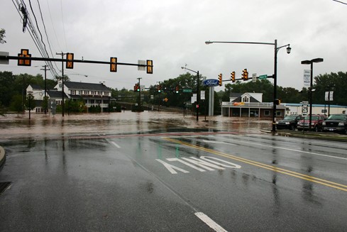
Flooding in Montgomery County, PA. Image courtesy of Montgomery County, PA.
In the face of a changing climate, accurately predicting and planning for climate vulnerability, including floodplain planning is of critical importance. Here, we aim to establish a climate-informed, scientific basis for floodwater planning for Montgomery County, Pennsylvania by 1) hosting meetings between Montgomery County Planners and a scientific subject expert, 2) hosting a public talk by an expert in the field aimed at an audience of local watershed management organizations and municipality leadership, and 3) hosting an interactive panel discussion to facilitate conversations between scientific experts and local leaders and managers. Results of these tiered conversations could lead to more informed and improved local flood water management strategies and development planning assessments by local community leaders.
Description
About the Community
Montgomery County, Pennsylvania is the third most populated county in Pennsylvania with a total population of over 830,000 and a larger population than four states and Washington DC. Like many suburban communities across the nation, Montgomery County has changed significantly over the past century, evolving from a primarily agricultural place with a number of large industrial towns to a dynamic employment hub that now also includes a wide range of high-tech and service jobs. Montgomery has always been a center of commerce and is home to towns and communities of diverse sizes, ranging from suburban to rural.
The Schuylkill River and Perkiomen Creek and other water bodies are important geographic features of Montgomery County. In the wake of recent storms, including Hurricane Ida, local stormwater flooding and flood plain management are of increasing importance to the community. Montgomery County is home to numerous active Environmental Advisory Councils (EACs), watershed organizations, and master watershed stewards. The Planning Commission has previously worked with municipal managers on watershed issues, collaborated on multi-municipal planning partnerships, led stormwater management education events and recently identified (via survey) that flooding is a top area of hazard/risk concern among residents.
About the Project
The community would like to identify the impact of climate change and future development on riverine flooding and share it with local resource managers and municipalities so that they can develop appropriate and informed planning measures, which will result in reduced risk and improved living for residents of Montgomery County, PA. We understand that FEMA flood maps underestimate damage risk and that unlike coastal areas, riparian areas haven’t been provided with projected climate change flood risk maps. That said, the community is interested in understanding the most up-to-date science investigating best practices for community protection The community is also interested in identifying local-scale variability and factors that may be relevant to future flooding.
Overall, the community hopes to engage with a scientist that would feel comfortable exploring how enhanced rainfalls/storm events (climate change impacts) and further development play a role in future floodplain risk. Output of this work will be a report led by the community scientist that outlines and potentially maps floodplain risk that can be distributed to local municipalities and watershed management collectives in order to support evidence-based decision making at the local level.
Timelines and Milestones
Due to the clear outlined need of this project, we hope to achieve our goals in a timely manner. We hope to receive a report from a partner scientist on flood plain vulnerability by September 2022, in order to incorporate findings from the report into the Montgomery County Hazard Mitigation Plan by December 2022.
Project Team
Community Leads

Jon Lesher is the Environmental Planning Assistant Manager for the Montgomery County Planning Commission. Jon’s duties include writing and reviewing ordinances, reviewing sewage and land use proposals, conducting planning related studies, and public outreach efforts. Jon is the project manager for the County’s Energy, Resiliency & Sustainability (ERS) Program, wrote the Renewable Energy Series and leads the County Planning Commission’s renewable energy and resiliency efforts. Jon is also involved in County-wide sustainability and resiliency initiatives. Before joining Montgomery County Jon has related experience working for the Brandywine Conservancy and in stormwater management. Jon earned his undergraduate degree from Ursinus College and a Master’s in Regional and Community Planning from Temple University.

Drew Shaw is an Environmental Planning Manager for Montgomery County, PA. His primary responsibilities include Stormwater issues (NPDES, Act 167 plans, special studies); municipal waste planning; hazard mitigation planning; environmental protection (natural areas inventory and development review for environmental impacts). He holds a Master of Regional Planning degree from Penn State University, and a B.S. in Environmental Studies/Geology from Binghamton University
Community Science Fellow

Hannah Palmer (she/her) is an interdisciplinary climate scientist and biogeochemist dedicated to the pursuit of science informed policies that promote healthy communities and environments. Hannah earned a Ph.D. in Earth and Planetary Sciences from the University of California, Davis in 2021, conducting research focused on understanding ocean and climate change in the recent past to better inform the future. During her Ph.D. she engaged in science policy work through the Presidential Graduate Opportunities for Leadership Development Fellowship and as an intern with the California Council on Science and Technology. Hannah is a Chancellor’s Postdoctoral Fellow at the University of California, Merced working to investigate how wildfire impacts carbon emissions and vulnerable communities adjacent to wildfire.
Collaborating Organizations
The mission of the Montgomery County Planning Commission (MCPC) is to strive to maintain and improve Montgomery County’s quality of life by promoting sound planning, strengthening the transportation network, supporting healthy and prosperous communities, and working to create vibrant places and protect natural and historic resources.
We will use our expertise to proactively guide strategic and long-range decisions through high-quality and innovative plans, promotion of choices, collaboration, engagement, and balancing competing interests, under the direction of the Montgomery County Board of Commissioners.
Status:
Complete,
Location:
Montgomery County,
Pennsylvania,
United States,
Managing Organizations:
No organizations
Project Categories:
Flooding,
Project Tags:
No tags