
Assessing Heat Vulnerability in Olympia, WA
Olympia, Washington, United States
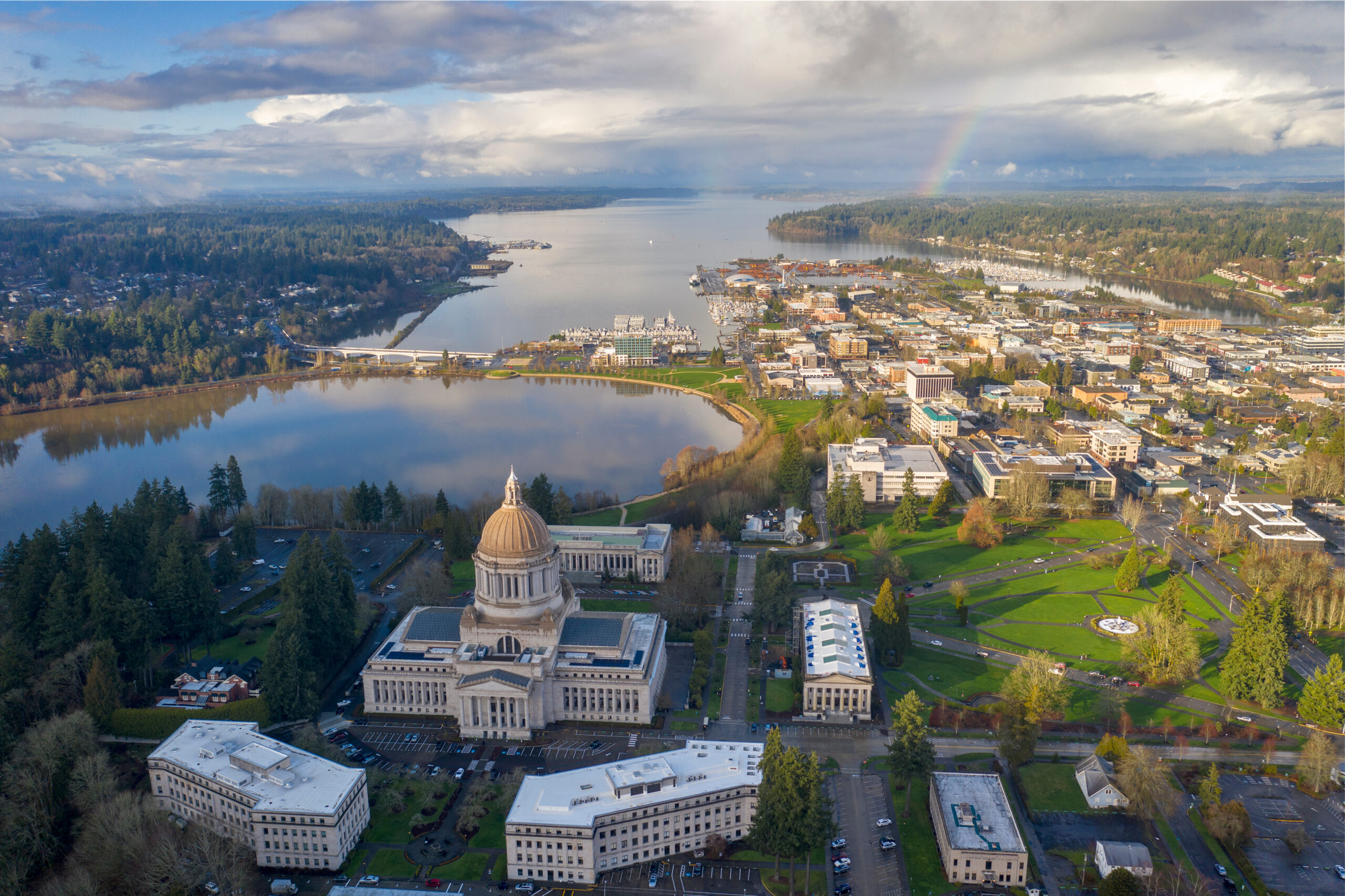
Photo courtesy of Pamela Braff.
The extreme heatwave of June 2021 sent a shock across communities in the normally mild Pacific Northwest; leaders in Olympia, the mid-sized capital city of Washington, identified preparation for future heat events as a central priority. In summer 2023, local government employees and scientific experts from across the US partnered to measure the effects of urban development on high temperatures in Olympia. The team deployed low-cost temperature sensors across the city for three months, then combined these temperature records with satellite measurements of surface radiation and land cover using machine learning. From this integrated dataset, they created a map of the distribution and magnitude of the “urban heat island” effect on near-surface air temperatures in Olympia, informing development planning in three highly built-up districts and providing a baseline for future heat monitoring.
In June 2021, communities across the typically cool and moist Pacific Northwest faced the most intense summertime heat in recorded history; in the coming decades, such heat waves are only expected to intensify. In response, the City of Olympia seeks to identify the neighborhoods and community members most impacted by urban heat islands in order to prioritize preparedness efforts and emergency responses. By combining remote sensing data with ground based measurements and other local data, our project will engage the community in producing a robust heat vulnerability map of Olympia.
Results
This project was conceived by Dr. Pamela Braff at the City of Olympia – herself a former Thriving Earth participant as a community science fellow. Pamela and Ben, the science fellow for the project, outlined a plan and recruited volunteer scientists with the relevant expertise. As team members joined, they [filled in] the initial outline from their wisdom and hard-earned experience. While we had initially considered a broader program with a strong outreach components (e.g. community participants carrying sensor), we decided that letting City staff handle the measurements would be much more feasible.
Once the team was formed, the initial phase involved planning the temperature sensors. We benefited greatly from team members, particularly Theo Ross and Anamika Srivastava, who were familiar with accessing community-relevant data from enormous satellite datasets. These datasets provided a first-guess at where the warmest areas would be, from which the team selected 30 locations to measure directly. Prof. Darryn Waugh, who has organized similar campaigns in Baltimore, provided direction on what technology to purchase – iButton temperature sensors – and how to use them.
Once plans were complete, the measurements went well. Hannah Ljunggren, the community lead for the bulk of the project, organized the placement and maintenance of the sensors, together with Lana Jarvis. Most sensors were placed on trees. Data had to be downloaded manually from each sensor once every two weeks; the few sensors that mysteriously disappeared were duly mourned.
Finally, TC Chakraborty used a method he had developed to combine the sensor measurements with satellite data we’d retrieved previously. This analysis is freely available on the project Github (https://github.com/TC25/ThrivingEarthOlympia) to facilitate future analysis. Finally, the team also compiled a report for the City of Olympia. [link to come]
Our large project team was both a key to success and a challenge for this project. The large number of scientists was often helpful, as various members were able to contribute actively when they had time without stalling progress when they were too busy. On the community leader side, personnel changes due to time constraints were a similar issue; Pamela initiated the project, but then handed leadership to Hannah for the summer and fall. The changes in participation did lead to some gaps in communication and challenges in consolidating all the work, but keeping all the plans, data and codes stored online (via Github, Google doc, Slack).
Reflections:
There are lots of great resources for future similar projects. Weather stations are becoming increasingly affordable, and there are many networks of weather station data already available (e.g. Ambient, though these are generally concentrated in wealthier residential areas). CAPA Strategies offers a select few cities a detailed heat island analysis in partnership with NOAA.
It’s helpful – perhaps necessary – to do a science project that the scientists involved already know how to do. On the other hand, this can be boring for the scientists; they will naturally want to learn something new and improve on past iterations. One way to make it personally valuable for scientists is for communities to communicate about how the data can and will be used, and let the scientists tune their study to that question; this piece is usually missing in scientist-initiated projects, which limits the usefulness of the work.
The project team met weekly (30 min – 1 hour) initially as the project was forming, then slackened to biweekly and monthly once the sensors were in place. Initial planning was relatively time intensive for the community lead and community science fellow, perhaps 3 hours/ week. Sensors were placed by the end of June, and taken down in late September.
Outside of meetings, time commitment varied widely over the course of the project. For the community leads, there were 2-3 full days of sensor placing/maintenance each month of the summer. Scientists generally contributed when they had time and there was a task at hand; that being said, they each did a lot.
Description
About the Community
The City of Olympia, the capital of Washington state in Thurston County, is a mid-size city of approximately 55,000 people situated on the southern end of the Puget sound. The City recently joined the Race to Resilience (https://icleiusa.org/pathways/resilient/race-to-resilience/), a global initiative of the United Nations that aims to build the resilience of global communities to climate risks. As a part of the Race to Resilience Pledge, the City of Olympia has committed to integrate climate change adaptation and resilience in all aspects of urban planning and undertake a community-wide climate risk and vulnerability assessment. Increasing temperatures, particularly summertime heat waves, are a particular concern, since the community is facing temperatures not previously experienced in this region with increasing frequency; temperatures in and around Olympia soared over 100 F for consecutive days in June 2021, claiming hundreds of lives across Oregon, Washington, and British Columbia. While the City already operates cooling centers during hot days, the City would like to better understand the spatial distribution and impacts of extreme heat in Olympia.
About the Project
The city government would like to assess the distribution of extreme heat impacts in Olympia, to better understand impacts of extreme heat on vulnerable populations, and to inform the development of future policies, plans, projects, and hazard mitigation strategies to prepare for and adapt to the impacts of extreme heat in Olympia.
To accomplish this, the volunteer science team would combine remotely sensed temperature data (e.g. from NASA’s ECOSTRESS mission) and demographic data regarding vulnerable populations (e.g. the US census) to map heat impact; this strategy has been successfully implemented in several mid-sized American cities. In addition, the scientists will collaborate with local government and community groups to engage residents in collecting local temperature measurements throughout the city during the summer of 2023; this community science data would be used to inform and/or validate the remotely sensed product.
A potential deliverable of the project is a multi-layered GIS map of the City of Olympia displaying the relative daytime and nighttime temperatures within the city, as well as the neighborhoods with greatest vulnerability to heatwaves (considering indicators such as age, general health, and access to air conditioning). The scientist and community leads would analyze these maps to identify which neighborhoods should be the focus of initiatives to reduce heat impacts. A second deliverable of this project may include recommendations of programs, policies, or projects to increase community-wide adaptation and resilience to extreme heat, particularly for vulnerable areas identified through this project. Together, these resources would help inform the steps Olympia is planning to take towards resilience to a hotter climate, and limit the health impacts of future heat waves.
Timeline and Milestones
The City would like to conduct a community heat mapping campaign in the summer months of 2023. This would require considerable community support and preparation, so developing a clear plan of action as soon as possible is a priority.
The City is also currently working on a project to conduct a tree canopy assessment and landcover classification, which will include an analysis of impervious surface cover. This project is scheduled to be completed by June 2023, and the results from this project may help inform the heat vulnerability assessment.
Project Team
Community Leads
[caption id="attachment_28363" align="aligncenter" width="200"] Pamela Braff Jul 11, 2019. (Photo by Aileen Devlin | Virginia Sea Grant)[/caption]
Dr. Pamela Braff is the Director of Climate Programs for the City of Olympia, WA. Pamela’s work includes developing internal staff capacity to address climate change and mainstreaming climate action across all levels of city policy, planning, and decision-making.
Before joining the City, Pamela served as a Coastal Policy Fellow for the National Oceanic and Atmospheric Administration and a Climate Extension Specialist at the Virginia Institute of Marine Science. She has led several initiatives to advance extreme weather and climate change resilience including developing local climate impact summaries, integrating future climate projections within hazard mitigation plans, and providing technical support for coastal resource management and flood risk planning.
Pamela received her PhD in Marine Science from William & Mary and an MS in Forest Resources and Environmental Conservation from Virginia Tech.

Hannah Ljunggren
Hannah Ljunggren currently serves as the Senior Climate Program Analyst for the City of Olympia. She manages various programs focused on helping the community become more resilient to the impacts of climate change. Prior to joining the City, Hannah worked for various other agencies to implement a variety of environmental programs and policies.

Lana Rae Jarvis
Lana Rae Jarvis is a current Evergreen State College student completing her degree in Environmental Studies with a focus on climate justice. She is so excited to be working with and learning from the City of Olympia’s Climate Program team. She hopes to do more work in the environmental field helping communities adapt to meet the climate crisis.
Community Scientists
Anamika Shreevastava
Hello! I am a NASA Postdoctoral Fellow working at the Jet Propulsion Laboratory (JPL) on thermal remote sensing applications, specifically mapping extreme heat in urban areas. I did my PhD from Purdue University in Ecological Sciences and Engineering where my doctoral thesis focused on Characterizing the intra-urban complexity of the Urban Heat Island.
Cities face the worst brunt of extreme heat in the changing climate as they already experience elevated local temperatures caused by urban heat island. To overcome this challenge, they must look for novel ways to adapt and be resilient. I view this problem as a trans-disciplinary challenge that is at the nexus of two interacting complex systems – extreme weather and urban socio-technological systems. Now at JPL, I use a combination of remotely sensed LST (from Landsat and ECOSTRESS) and high-resolution Weather Research Forecast (WRF) modeling to simulate urban thermal dynamics at a neighborhood scale.
Darryn Waugh
Darryn Waugh is a Professor in the Department of Earth and Planetary Sciences at the Johns Hopkins University. His primarily research interests are large-scale atmosphere and oceanic flow and transport, with a focus on understanding global environmental issues such as stratospheric ozone depletion and climate change. In recent years his interests have expanded to include planetary atmospheres and urban heat and air quality.
Darryn was born in New Zealand, and obtained Bachelor and Masters degrees in Mathematics from the University of Waikato, NZ in 1985 and 1987, respectively. He earned his Ph.D. in Applied Mathematics at Cambridge University, UK in 1991. He was a post-doctoral fellow at MIT and a research scientist at Monash University, Australia, before joining the Hopkins faculty in 1998.
Tirthankar (TC) Chakraborty
TC is an Earth scientist in the Atmospheric Sciences and Global Change Division of the Pacific Northwest National Laboratory. He is currently working on improving urban representation in land models using various observational products, including satellite-derived estimates, and examining extreme events over coastal cities. Previously, he completed his PhD from Yale, where he developed a surface energy balance perspective to aerosol-climate interactions by combining theory and climate modeling. TC has worked extensively on the urban heat island effect by leveraging satellite measurements, crowdsourced weather station data, and conceptual modeling frameworks. He thinks that cities will be the nexus of climate adaptation and is interested in optimal strategies for minimizing heat stress and its within-city disparities.
Theo Ross
Theo Ross graduated from the University of Oregon with a bachelor’s degree in geography and spatial data science. He is currently working on a NASA DEVELOP project at Jet Propulsion Laboratory with science advisor Dr. Anamika Shreevastava to investigate the effects of urban tree cover on heat mitigation in Los Angeles. Theo is dedicated to addressing environmental issues by developing and implementing solutions through GIS and innovative technology.
Community Science Fellow

Benjamin (Ben) Taylor is the community science fellow for this project, which means that he supports the community lead and volunteer scientist in their collaboration and communication. Ben is a graduate student at the University of California, San Diego, where he studies the distribution of warming and acidification in the global ocean; before that, he received a BA in Physics from Princeton University. He’s passionate about connecting global insight to local, relational knowledge of the wonderfully complex system of life-giving geophysical flows that we inhabit.
Status:
Complete,
Location:
Olympia,
United States,
Washington,
Managing Organizations:
No organizations
Project Categories:
Natural Hazards,
public health,
Sustainability,
Project Tags:
No tags