
Identifying future urban flood risk hotspots
Richmond, Virginia, United States
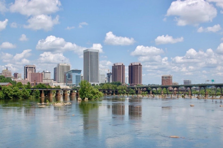
City of Richmond skyline
Description
Context
Richmond is getting hotter and wetter due to climate change. In 2017, Mayor Levar Stoney announced RVAgreen 2050, the City’s equity-centered climate action and resilience planning initiative. RVAgreen 2050 aims to achieve net zero greenhouse gas emissions by 2050 and to help the community adapt to climate impacts such as extreme heat, extreme precipitation and sea level rise. As an input to the RVAgreen 2050 planning process, which launched in early 2020, the Office of Sustainability is conducting a climate vulnerability and risk assessment, which identifies the people, neighborhoods, built assets, and natural resources in the city that will be most impacted by climate change. Given that there are limited resources to address the City’s adaptation and mitigation needs, it is important to conduct this assessment to prioritize actions that address the highest risks and most immediate vulnerabilities, while also allowing for future flexibility. Office of Sustainability staff have evaluated and mapped in ArcGIS over 150 demographic variables, built assets, and natural resources. These range from factors that affect a person’s ability to deal with very high temperatures, such as respiratory illness and access to air conditioning, to critical community assets such as police stations and bridges that could be impacted by increased storms. The Office of Sustainability also created an innovative map-based tool called the Climate Equity Index that is available to all city staff and the public to enable a better understanding of how climate change is impacting the community.
Project Scope
Precipitation modeling for Richmond will be an integral part of the city’s climate vulnerability and risk assessment. The city worked with a class at Drexel University to model precipitation projections in Richmond at various future time scales while accounting for the ways in which climate change will modify the volume, timing, and distribution of precipitation throughout Richmond. The precipitation modeling results were completed in August 2020. A sample of the data is below; the full dataset and methodology will be provided to the project scientist.
[caption id="attachment_24628" align="aligncenter" width="624"]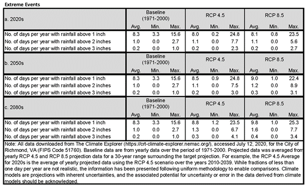 Projected extreme events for Richmond, VA[/caption]
The project idea is to further develop the city’s assessment by applying the precipitation modeling projections to Richmond’s topography and built infrastructure and to identify the areas and assets that are most vulnerable to future flooding. The resulting flood maps will help the city and the community assess the exposure of Richmond’s critical infrastructure and community resources to flooding, and provide a detailed dataset to identify at-risk areas and assets. It will also help to prioritize areas of the city in need of adaptation actions.
An example of this type of modeling was completed for the City of Somerville, MA’s climate vulnerability and risk assessment (see Appendix D for methodology). A city-wide “bathtub analysis” was used to apply future design storms (Storm models created by the researcher to test different assumptions about the impact of a storm based on a storm’s duration, frequency, etc.) to the city terrain to identify areas within the city that are most vulnerable to flooding due to local topography.
[caption id="attachment_24629" align="aligncenter" width="624"]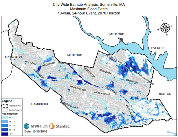 City-wide bathtub analysis for Somerville, MA[/caption]
This information will be made available to all city staff and the public to enable Richmonders to better understand how climate changes could impact the city and how they can adapt to future climate change. The community hopes that, in partnering with an expert scientist, Richmond citizens and government will acquire flood maps that clearly represent flood-risk scenarios for the city. The flood maps and associated data will be helpful communication tools for key community stakeholders and the city’s RVAgreen 2050 initiative.
Timeline
- April 2020: RVAgreen 2050 community engagement begins
- August-September 2020: Drexel University delivers precipitation projections and methodology report
- February-March 2021: RVAgreen 2050 community engagement phase #2 begins – ideally would have flood risk maps by this time
- December 2021: RVAgreen 2050 draft complete
Ideal Deliverables
- Report/set of files with:
- Estimates of future design storms based on data from Drexel University class as described above for:
- 10-year, 24-hour design storms for present day, 2030s, 2050s, and 2070s
- 100-year, 24-hour design storms for present day, 2030s, 2050s, and 2070s
- Current flood maps based on bathtub analysis and present day 10-year and 100-year, 24-hour design storms (PDFs and ideally in GIS format)
- Work with city staff to compare current flood maps to existing flood locations to be identified by city staff through complaint reports and other sources
- Determine where modification may be needed to bathtub model and/or other considerations for more detailed modeling efforts in the future
- Future flood maps (PDFs and ideally in GIS format) for:
- 10-year, 24-hour design storm for 2030s, 2050s, and 2070s
- 100-year, 24-hour design storm for 2030s, 2050s, and 2070s
- Short methodology document
- Recommendations on how the city should document flood events for future modeling that will be more detailed in nature; also potentially include recommendations on priority areas/actions to address based on modeling project results
- Estimates of future design storms based on data from Drexel University class as described above for:
- 1-hour virtual City staff and external stakeholders meeting on project methodology and results
- 5-10 minute overview video/Zoom recording for lay audiences to understand process and results
Data Availability: The City of Richmond has geographic data available in many formats including LIDAR, ortho, and others as needed.
Project Team
 Brianne (Mullen) Fisher is the Sustainability Coordinator for the City of Richmond, Virginia. Brianne supports efforts related to RVAgreen 2050, the City’s equity-centered climate action and resilience planning initiative to achieve net zero greenhouse gas emissions by 2050 and help the community adapt to the impacts of climate change. In previous roles, she has worked for Yale University, the Urban Sustainability Directors Network, and the Partnership for Smarter Growth. Brianne has a Juris Doctor from the University of Richmond School of Law and a Master of Urban and Regional Planning from Virginia Commonwealth University.
 Jenn Clarke is the Public Education and Outreach Coordinator for the City of Richmond’s Stormwater Utility and their integrated RVAH2O clean water initiative. With diverse experience in communications at the intersection of human and environmental wellness, Jenn is passionate about building relationships, partnerships, and community in an effort to effect positive hands-on change to improve the health of the James River and how life is enjoyed along it. Jenn originally hails from Washington State, where she received her BA in Environmental Studies at the University of Washington.
 Eva Kostyu, Community Science Fellow, Thriving Earth Exchange
 Dr. Steven Emerman, Community Scientist
Dr. Steven Emerman has a B.S. in mathematics from The Ohio State University, M.A. in geophysics from Princeton University, and Ph.D. in geophysics from Cornell University. He taught hydrology and geophysics for 31 years, including teaching as a Fulbright Professor in Ecuador and Nepal, and has 70 peer-reviewed publications in these areas. After retirement from university teaching, Dr. Emerman founded Malach Consulting, which specializes in evaluating the hydrologic impacts of development projects, such as dams, mines, pipelines, residential development, and timber harvesting. Dr. Emerman has evaluated proposed and existing development projects in North America, South America, Europe, Africa, Asia and Oceania, and has testified before the U.S. House of Representatives Subcommittee on Indigenous Peoples of the United States. He is the Chair of the Body of Knowledge Subcommittee for the U.S. Society on Dams and a co-author of Safety First: Guidelines for Responsible Mine Tailings Management.
Status:
Complete,
Location:
Richmond,
United States,
Virginia,
Managing Organizations:
No organizations
Project Categories:
Climate Change,
Flooding,
Project Tags:
No tags