
Assessing Wetland Capacity to Provide Flood Control Benefits
Staten Island, New York, United States
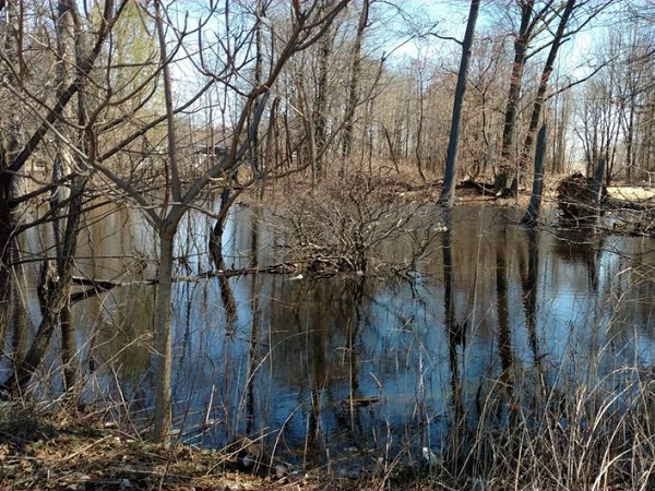
Photo Courtesy of Gabriella Velardi-Ward
Results
The Team
Gabriella Velardi-Ward, Coalition of Wetlands and Forests, [email protected]
Ericka Naklicki, Professional Wetland Scientist, T&M Associates, [email protected]
Results
The focus of the Staten Island project was to work with a Professional Wetland Scientist (PWS) to understand the limits of the wetlands on a vacant property slotted for development in Graniteville, Staten Island. The PWS, Ericka Naklicki, helped Gabriella Velardi-Ward with the Coalition of Wetlands and Forests (CWF), identify the limits of the wetlands and uplands on the property, obtain a better understanding of the benefits of the habitats, and navigate the regulatory process underway for the proposed development of the property.
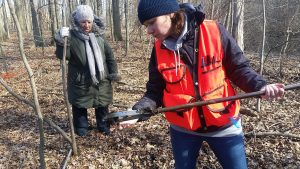
Gabriella and Ericka met on the property twice in order to assess the limits of the wetlands through vegetation inventories and assessing the soil conditions. Ericka took data logs and conducted desktop research to identify rare, threatened or endangered species on the site. Ericka provided a memo of field work findings and a document on the benefits and values of the habitats discovered on site.
Together, given the field assessments and wetland delineation, Gabriella and Ericka concluded that preserving the wetlands and forest would be in the best interest of the community as a whole and to the city and state. The Graniteville Habitat Wetlands and Functions/Values document details how the forested freshwater and tidal wetlands and upland areas provide several values for the community and local flora and fauna. One key benefit of the wetlands and forest is increased flood protection from high tide flooding, projected to worsen in the coming decades with climate change and sea level rise. The document was shared with CWF members via an email listserv and the group plans to use it during future hearings.
 Media coverage was very important for garnering attention. CWF used the media coverage to launch letter writing campaigns to urge the New York State Department of Environmental Conservation (NYSDEC) to closely consider the functional benefits that the Graniteville wetland provides to people living nearby. CWF used electronic outreach as well as person to person contact. During the last week of August 2019, CWF made a big push to submit over 1,500 letters requesting a public hearing in order for the public to make the case of the importance of the wetland and therefore for the denial of a permit to remove 1800 mature trees and to construct a large strip mall on the Graniteville forested wetland. CWF also set up tables at supermarkets and invited people to sign form letters requesting a hearing and stating how the loss of the wetland will impact their lives. As a result of the outpouring in response, City, State and Federal elected officials began to support the position of CWF, to save the Graniteville Forested wetland aka the Graniteville Swamp. They began sending letters to NYSDEC concerning the development, asking DEC to reject the application for a permit and stating the importance of saving this wetland. New York City’s Comptroller, Scott M. Stringer, sent a letter urging the state to reject the permits for the proposed development. Congress Member Max Rose, State Senator Diane Savino, State Assembly Member Nicole Malliotakis and State Assembly Member Michael Cusick sent similar letters.
Project Outputs:
- Graniteville Wetland Memo – FINAL – Preliminary Wetland Investigation – conducted on March 23rd, 2019
- Graniteville Wetland Habitat benefits_values -Graniteville Wetland Habitat Wetlands Functions and/or Values Report
- Site Map – GIS Environmental Constraints Maps
Articles:
Activists Still Hoping to Derail Plan to Develop on Staten Island Wetland – City Limits, June 24, 2019
Vital Staten Island Wetlands About To Get A BJ’s Wholesale Club – Gothamist, August 28, 2019
Comptroller Stringer Calls on State DEC to Reject Development Permit on Staten Island’s Graniteville Swamp Wetlands – New York City Comptroller, Press Release, August 30, 2019
Scott Stringer urges DEC to deny permits for BJ’s development in wetlands; Island pols call for public hearing – silive.com, August 30, 2019
Stringer calls on state to deny permits for Staten Island BJ’s – Crain’s New York Business, August 30, 2019
Encroaching development threatens a crucial Staten Island wetlands – Curbed New York, September 6, 2019
Reflections
From this project, others may learn better ways to partner with Thriving Earth Exchange for their own purposes. For instance,
The team noted that the following contributed to the success of the project:
- Partnering with a reputable community science partner (Ericka Naklicki, PWS) helped lend credibility and access resources to increase the community’s knowledge of the issue and spark productive conversations with the broader community and local elected officials.
- Visiting the wetland to conduct field assessments in different seasons helped to capture seasonality and changes.
- Communication was vital to ensure both project progress and that all team members were on the same page.
However, there were a few key things that the team would do differently if they had the chance to do this project again:
- Visit the site more often to collect data and make observation – this could would have allowed the team to notice things that hadn’t been noticed on earlier field trips.
- Check for the Endangered Eastern Mud Turtle earlier in the season and find a herpetologist to contract to perform the assessment.
- (From the community leader’s perspective) – Do some homework ahead of partnering with a scientist to better understand the suite of wetland tests and assessments necessary, to know more fully what options there might be in working with the scientist, and to be able to better identify goals.
To other teams currently pursuing Thriving Earth Exchange projects and for those that anticipate doing a Thriving Earth Exchange project, the team recommends:
- Be prepared with information and basic knowledge of scientific techniques ahead of time.
- “Even in the face of impossible odds, you can’t win it if you’re not in it”. – Keep the pressure on at all times. Don’t lose hope.
- Keep children and their futures in your mind when you do this work.
Description
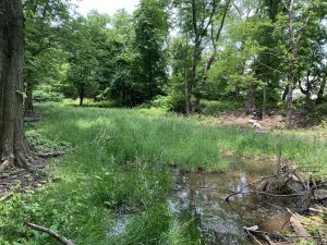
Hurricane Sandy was a tragic event for Staten Island, one of New York City’s 5 Boroughs. More than half of the deaths that occurred in New York City during the storm occurred on Staten Island. The storm resulted in extensive flooding, power outages and downed power lines across the Borough. Once home to an extensive network of tidal wetlands, nearly two-thirds have been filled in and developed. Of the remaining wetlands across Staten Island, estuarine emergent wetlands, or tidal salt marshes, predominate. Palustrine emergent and forested wetlands (inland freshwater wetlands that lack flowing water) are also found spectacled across the landscape. It was these wetlands that protected some residents from flooding during Hurricane Sandy.
Residents of Graniteville, a predominately African American and Hispanic neighborhood in the north west section of Staten Island, attribute coastal flood protection during Hurricane Sandy to a 30-acre wetland known as the Graniteville Swamp and Forest on South Ave. The wetland has both freshwater wetlands and tidal influence from Arthur Kill. The residents living on the east side of the wetland did not flood and point to the functional benefits that the wetland provided, including water retention, wind blockage, and reduction in the energy brought on by high storm surges. Future flood maps produced by New York City government, including New York City Planning and FEMA, show increased risk to the neighborhood—a mobile home park with approximately 120 homes sits just to the west of the wetland is at total risk of inundation under future flood scenarios. Residents are concerned about high tide flooding, storm surge flooding and heavy rain events. Adding to this worry is a pending proposal to build a BJ Wholesale Club and additional retail on 18 acres of the Graniteville Swamp. Currently, applications for permits to allow the builder to proceed are currently being reviewed by the New York State Department of Environmental Conservation (NYSDEC). Initial permits applied for prior to 2012 were denied as NYSDEC identified the area as wetland. In August 2012, two months before Hurricane Sandy, a subsequent lawsuit settled in favor of the developer that the land is a forest and can be developed.
The Coalition for Wetlands and Forests was established to raise awareness about the proposed destruction of the Graniteville Swamp and how its loss will impact residents. The group is comprised of residents, civic associations, condo associations and environmental groups. Together, they rally every Saturday morning, canvass to talk to residents, write letters to their local elected officials, and organize educational forums on topics such as environmental racism. Residents fear what will happen to the important wetland benefits they receive if the development moves forward. The Coalition of Wetlands and Forests would like to find a scientific partner who can determine whether the Graniteville Swamp is in fact a wetland and provide written evidence to document that classification. They would also like documentation of the flood risk that Graniteville is facing. The goal of this Thriving Earth Exchange project is to bring scientific evidence and understanding to the questions and priorities of local residents, so that residents can use that science to make decisions and take actions.
This project has been conceived and designed in partnership with community leaders at The Coalition for Wetlands and Forest and with our national partner, Flood Forum USA.
Project Team
Community Leads
Gabriella Velardi-Ward is the founder of Coalition for Wetlands and Forests in Graniteville, Staten Island, NY.
Gabriella is an artist, photographer, architectural designer and priest. As part of her architectural degree she studied ecology and urban planning. She worked for the NYC Department of Parks and Recreation (DPR) for 23 years as a designer and construction supervisor. As an architectural designer, she represented DPR to the Mayor’s Office of Construction for Sustainable Construction and helped formulate policy, city wide, for large public projects, which now require sustainability in design and construction.
In 2017, she called together Staten Island environmental groups, civic associations, condo associations and people who care, and formed the Coalition for Wetlands and Forests in order to prevent the destruction of the Graniteville Wetland Forest. If the wetland forest is lost, this environmental justice community will be at high risk of flooding. The wetland is the only buffer against climate change and air pollution from the many sources of toxins around the community.

Sarah Lipuma is an environmental researcher based in New York City. She is employed as Research Assistant at the Hudson River Foundation, a not-for-profit organization which promotes environmental stewardship and scientific research in the Hudson River Estuary. She volunteers for the Coalition for Wetlands and Forests, a grass-roots community group in Staten Island that aims to protect a wetland from the development. She plans to attain a Master’s Degree in Environmental Policy to explore climate change adaptation through the lens of climate justice, to make sure discriminatory policies in land use are not repeated and worsened by the destructive effects of sea level rise and flooding.
Science Liaison

Ericka Naklicki is a Principal Environmental Scientist for T&M Associates in New Jersey. She has 17 years of experience in the field of environmental consulting. She is certified as a Professional Wetland Scientist (PWS) by the Society of Wetland Scientists. Her areas of expertise include wetland delineations as well as the preparation of applications and final reports to the regulatory agencies.
In addition, she is experienced in the preparation of Geographical Information Systems (GIS) maps for various project types including wetlands, floodplains, threatened and endangered species, aquifer and land use maps. She also has experience using Global Positioning System (GPS) surveying equipment.
Collaborating Organizations
This project is part of one of TEXs’ new cohorts. TEX has partnered with Flood Forum USA which supports grassroots flood groups across the country by helping them develop strategies for a sustainable future. TEX is working with twelve of their grassroots groups to connect them with scientists who can help them better characterize neighborhood-level flood risks and work effectively with local decision makers to mitigate those risks.
![]()
ISeeChange is dedicated to empowering communities to document and understand their environment, weather and climate in order to increase resilience. ISeeChange mobilizes communities to share stories and micro-data about climate impacts to inform and improve climate adaptation and infrastructure design. Their platform, tools, and investigations provide equitable, iterative ways for residents to personalize, measure, and track climate change impacts and better participate in community adaptation decisions.
Each post is synced with weather and climate data and broadcast to the community to investigate bigger picture climate trends. Over time, community members can track how climate is changing, season to season, year to year, and understand the impacts on daily life.
ISeeChange is a strategic partner of Thriving Earth Exchange as community members use their platform and tools to better characterize, visualize, and communicate neighborhood-level climate trends and co-develop solutions to mitigate those risks.
Status:
Complete,
Location:
New York,
Staten Island,
Managing Organizations:
Thriving Earth Exchange,
Project Categories:
Climate Change,
Flooding,
Natural Hazards,
Project Tags:
No tags