
Connecting community-collected data with nationwide datasets to scale up flood mitigation efforts in coastal urban areas across the U.S.
Alabama, Coastal communities, Connecticut, Florida, Georgia, Louisiana, Maryland, Massachusetts, Mississippi, New Jersey, New York, South Carolina, North Carolina, United States
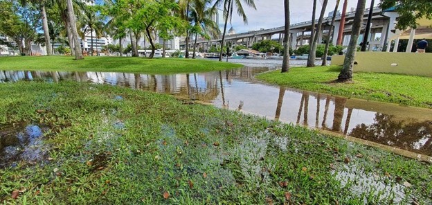
Flooding in Miami, Florida. Photo by Claudia Sebastiani shared through the ISeeChange platform.
ISeeChange is a global climate data and engagement platform where local leaders, engineers, and the public build solutions together. It is seeking nationwide datasets to pair with community-collected data to scale up flood monitoring efforts in coastal urban communities across the U.S.
Description
Background
ISeeChange is a climate data and engagement platform headquartered on one of America’s adaptation frontlines —the Gulf Coast—and informed by the communities we serve. We are a diverse team that includes a mix of journalists, user experience designers, engineers, data scientists, urban planners, and anthropologists.
ISeeChange began as a prototype and concept in Colorado from field interviews with drought-impacted farmers and ranchers. As we scaled our community globally, we started to see opportunities to grow insights generated through observation, communication, and education into direct impact and local solutions. After developing successful prototypes on urban heat and flooding in Harlem and New Orleans, we committed to using the community sourced data and stories to co-design climate solutions, not just identify problems. In 2018, we became a thriving social impact start-up with partners and clients across the United States and the globe.
ISeeChange partners with many coastal communities that are experiencing flooding, such as Miami, FL, Wilmington, NC, Ocean City, NJ, and New Orleans, LA (see hyperlinks for project information). Through photos, storytelling, and other data measurements, these communities provide invaluable flood event documentation. In real-time, this hyper-local information is shared among community members and aids in disaster response. Collecting this data over time reveals broader patterns and impacts of a changing climate. Because climate change is causing increased flooding in many urban coastal communities, ISeeChange is expanding its community partnerships across the U.S, and globally. To scale up their approach, ISeeChange seeks to use ancillary datasets that inform flood monitoring efforts in coastal urban areas across the country. Not only will these datasets supplement back-end analysis of community-collected data (e.g., fill in data gaps), they will also directly assist communities in local decision-making on flood monitoring.
The Project
ISeeChange seeks the following types of datasets and welcomes scientific insight regarding additional scalable datasets that can inform community flood monitoring:
What?
Modeled data, such as climate projections, or empirical data relating to factors such as weather, soil saturation, soil permeability, infrastructure, and tides.
Where?
U.S. nationwide data, and if possible, global data (such as select remote sensing data). While there is often a trade-off between spatial extent and spatial resolution, these datasets should be impactful at the community-scale.
When?
Historical and real-time data for use in flood mapping and active flood monitoring.
How?
Accessible, open-source, and minimal processing required.
Timeline
Proposed Project Timeline
- March 2021 → Search for, select, and connect with scientific partner(s)
- April-May 2021 → Work collaboratively with scientist(s) to identify useful datasets; access and prepare datasets for application
- Summer 2021 → Begin incorporating datasets into community science efforts (community engagement, back-end processing)
This project will be iterative and require regular conversations with scientific partner(s). While many coastal urban areas experience flooding events, a variety of factors unique to each community (e.g., housing types, location along a shoreline or river) will require a nuanced and iterative approach to data access and application.
Project Team
Community Leaders
 Julia Kumari Drapkin is dedicated to connecting communities to each other and their changing environments and is the CEO and founder of ISeeChange. Drapkin founded ISeeChange after over a decade of reporting natural disasters and climate change across the globe and in her own backyard on the Gulf Coast. Under her leadership, ISeeChange has received national and regional awards, as well as recognition by the Obama White House Climate Data Initiative, NASA, MIT Solve, Echoing Green, Grist, the American Association for the Advancement of Science, and TechStars. Prior to journalism, Julia did anthropology research for seven years in Central America.
 Lindsey Wagner is a civic researcher and designer. Through early 2013, she was the user experience lead on eight national public media projects, one of which was the prototype of ISeeChange. Outside of working with ISeeChange, Lindsey has also led field research in digital accessibility for people with vision impairments for the State of Massachusetts, prototyped financial equity tools for low-income college students at Blue Ridge Labs, and researched immigration journeys and access to paid leave for the Public Interest Technology group at New America.
 Irini Genitsaridi is the lead data scientist at ISeeChange with many years of experience in artificial intelligence, machine learning, statistical modeling, and web application development areas. During the last decade she worked on the architecture and development of innovative data science solutions as a member of international and interdisciplinary teams, in private companies, research foundations, and non-profit organizations. Irini is focused on quality and creativity with self-motivation to streamline processes. Born in the beautiful island of Greece, Crete, she completed a PhD in Artificial Intelligence and MSc, BSc in Computer Science at the University of Crete.
Community Science Fellow, AGU Thriving Earth Exchange
 Susan Lamb earned an M.S. in Soil in Water Sciences from the University of Florida and her interest in human-water relationships has guided her to research ranging from irrigation decision-making on the U.S. High Plains to community-led water projects in rural Nicaragua. She is passionate about bridging communities and scientists to support water justice efforts on scales both local and global. In addition to her current role as a Community Science Fellow, she is also a researcher with NASA DEVELOP partnering with Indigenous Peoples on the Northern Great Plains to monitor flooding on tribal lands.
Status:
Complete,
Location:
Alabama,
Coastal communities,
Connecticut,
Florida,
Georgia,
Louisiana,
Maryland,
Massachusetts,
Mississippi,
New Jersey,
New York,
North Carolina,
South Carolina,
United States,
Managing Organizations:
No organizations
Project Categories:
Flooding,
Project Tags:
No tags