
Measuring the impact of flood management strategies on flooding and water quality in a historic residential neighborhood
Ellicott City, Maryland, United States
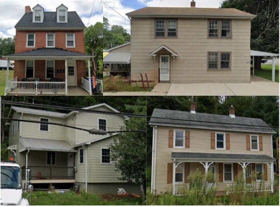
Homes in the 8600 Main Street neighborhood of Historic Ellicott City, Maryland, many of which are immediately adjacent to the Hudson Branch tributary of the Patapsco River, are highly threatened by flooding and associated runoff pollution. These risks are exacerbated by the recent approach to flood management, which relies upon an 108” culvert, which is well past its lifespan, that intensifies the volume and flow rate of floodwater in the neighborhood. The county’s flood management strategies are currently being reevaluated but there is no indication that preservation of residents’ homes is a priority in this decision process. Community residents have identified many potential alternative approaches, including many nature-based strategies, to mitigate the flood risk using locally available resources. Our objective is to quantify the floodwater volume and velocity as well as water quality concerns associated with different flood management strategies and identify possible nature-based solutions that could be implemented on a local scale. This information would allow neighborhood residents to advocate, as well as seek funding and other support, for improved flood management approaches, which are deeply needed so that residents can remain in their homes and mitigate the risk of catastrophic flooding.
Description
For Collaborators
We are still open to the partnering with additional experts who may have something to contribute to our collaboration, so please get in touch if this describes you! In particular, we are seeking an expert who can contribute technical skills in stormwater modeling at a local scale. We are open to working remotely with scientists located anywhere in the USA or elsewhere.
The Community and the Challenge
The 8600 Main Street neighborhood is located in the West End Main Street community of Historic Ellicott City, Maryland, a historical mill town on the Patapsco River. The neighborhood borders the Hudson Branch tributary of the Patapsco, a short distance upstream from the downtown district. Though located in a wealthy county, the neighborhood faces the loss of generational wealth and heritage; it is threatened by gentrification and a growing risk of catastrophic flooding, and many heritage residences have been acquired by the county. There are around 60 homes in the West End of Main Street as well as other heritage communities along the periphery of Main St and local tributaries that are threatened by severe flash flooding.
The 8600 Main Street neighborhood is working with Thriving Earth Exchange to gather resources to enable efforts to protect and preserve the heritage community. They aim to move beyond a focus on rebuilding after flooding to a new framework of building long-term resilience. Residents are engaging with a wide range of resources to build resilience, and they hope that scientific data produced in partnership with Thriving Earth Exchange can galvanize and support their ongoing efforts to preserve their community.
For more information on the challenges facing Historic Ellicott City and their work to build resilience, you can view the following resources:
- Ellicott City Safe and Sound
- Anthropocene Alliance partnership with Ellicott City
- Let’s Work to Save Historic Ellicott City community Facebook page
The Project
We aim to collect data to articulate multiple components of the flood risk threatening the 8600 Main Street neighborhood along the Hudson Branch:
- Floodwater volume. The current culvert was reduced in size following the 2011 flash flooding and is not sufficient to reduce the volume of floodwater that threatens homes along Main Street during flooding and may even exacerbate risks by redirecting and increasing the floodwater velocity around homes. At the same time, green infrastructure features that historically reduced flood risk, including floodplain walls, floodplains and plunge pools, were damaged in 2011 flash flooding and since have been neglected and continue to remain dysfunctional. We aim to quantify the impact of current channel management (or lack of) on flood risk and estimate the impact of alternative strategies.
- Water quality concerns. Floodwater washes over a local commercial property, potentially picking up contaminants that are then carried through residents’ properties and homes. We aim to identify these contaminants and any associated risks, and to identify possible solutions that could be implemented on a local scale.
- Potential nature-based approaches to mitigating flood risk. There are several local resources that could provide opportunities to mitigate flood risk, including the following: land that could potentially be used for floodwater detention; existing vegetation as well as opportunities to expand vegetated buffers on residents’ riparian property; a record of historical green infrastructure that was previously successful in lowering flood risk and could possibly be restored.
The community hopes to make the results of this project available to relevant governing bodies and management agencies at the municipal, state, and/or federal level. Neighborhood residents also plan to use the results to inform their advocacy for effective flood risk solutions and in applications for funding and other external support to implement solutions. Flood risk mitigation strategies for the Hudson Branch are currently being reviewed as part of broader discussions of watershed management, so there is some urgency in obtaining data to inform residents’ participation in this decision process.
Project deliverables will likely include data reports and visualizations related to floodwater volume and velocity, water quality concerns, and the potential role of nature-based flood mitigation. These will be provided to community members and are intended to be used for communicating with municipal and state government entities in upcoming flood management decision processes.
A new flood management strategy is necessary for residents of the 8600 Main Street community to continue living in their neighborhood and avoid serious risk to their homes and lives. The data we plan to collect through this project are expected to significantly improve residents’ ability to participate in decisions about flood management in their neighborhood and to advocate for a new approach to flood management that mitigates the risk to their heritage community. They are eager to collaborate and share knowledge with the many communities across the country facing similar flood risks.
Timeline and Milestones
- The project should begin as soon as possible due to the existing flood risks facing the community.
- A review of flood management strategies (CWA Section 404) for the Hudson Branch watershed is underway, though the timeline for this process is not currently known. The community hopes to use results obtained from this project to inform their participation in this decision process and to support their ability to advocate for evidence-based strategies that mitigate the risk to their neighborhood.
- The initial data collection phase may be relatively short in duration, but there may be additional follow-up data collection; details will be worked out with the partnering scientist(s).
Project Team
Community Lead

Gayle Killen has supported community recovery from runoff rapids since 2011, after witnessing devastation in her historic community first hand. She has since flood proofed her home through wet-proofing and rainscaping and works to help the remainder of the community become resilient as well. While not specifically “anti-development”, she recognizes the role that redevelopment plays in historic communities such as her own and strives to preserve as much as possible. Gayle is a certified Wildlife Habitat Naturalist and a Natural Building enthusiast. She has used native rain scapes to collect and manage runoff, reinforced the walls of her 1809 historic Icehouse with Hempcrete, and has installed a TESLA SolarRoof with Powerwall batteries to preserve her historic home located in a Chronic Disaster Zone.
Community Scientists
Jose M Molina is a hydrologist, climate researcher and water resources engineer specializing in environmental time series analysis and forecasting, climate change modeling, stochastic simulation of hydrologic systems, and sustainable water solutions for international development. Research interests include but not limited to statistical downscaling incorporating large-scale climate variability, Earth science data products for hydroclimate extreme events analysis and prediction, climate-based risk assessment of food and water systems and irrigation and drainage infrastructure. Jose also volunteers in fog projects that provide clean and safe drinking water to rural communities in developing countries. In his free time, he loves riding his mountain bike in Patapsco, Maryland.

Marita Roos is a registered landscape architect and planner who writes, designs, plans, builds and teaches with the aim of enlarging our participation in the urban/natural environment. Marita is principal designer and planner with UrbanBiology LLC, focusing on planning for green infrastructure, parks and green streets, integrated with local goals for climate resilience, art and placemaking. Her recent work with the Neighborhood Design Center includes the Windom Road Green Street & Barrier Art project with the town of North Brentwood, and the Story of Water and Art with Joe’s Movement Emporium. She is currently working with NDC on designs for David C Driskell Park in Hyattsville, MD, honoring the life and work of a notable local Black artist.
Marita has worked and collaborated with numerous organizations throughout her career including Vita Nuova Inc, DC Clean Rivers, the City of San Antonio, Andropogon Associates and HNTB engineering. For one of her favorite projects, the 2008 Central Delaware River Waterfront Visioning Plan, she facilitated engagement activities with dockworkers, residents, property owners and advocacy groups to regenerate seven miles of Philadelphia shoreline as a living, diverse, environment. Marita holds an MSc in biodiversity management from the University of London Imperial College at Wye and an MLA in landscape architecture from the University of Georgia.
Pearce Wroe is a professional water resources engineer who has been practicing stormwater engineering since graduating with a B.S. in civil engineering from the University of Maryland, College Park in 2006. In 2020 he founded the Stormwater Shoppe, LLC to apply his engineering experience in a way that makes people happy about stormwater management. He is also currently a Stormwater Management Project Manager for the City of Gaithersburg, MD where he reviews land development plans and manages stormwater capital improvement projects. Prior to founding the Stormwater Shoppe, Pearce spent over a decade designing stormwater facilities and drainage systems of all shapes and sizes. His passion for a beautiful natural world through stormwater management guides his practice and sometimes annoys his friends and family who don’t feel quite as strongly about it.
Community Science Fellow

Caitlin Mandeville is an ecologist and PhD candidate at the Norwegian University of Science and Technology in Trondheim, Norway. Her research focuses on conservation applications of biodiversity citizen science, touching on the topic from several perspectives including open data access, intersections between citizen science and outdoor recreation, and the role of citizen science in protected areas. Before her current work, she earned a B.Sc. from the University of Wisconsin-Madison, explored ecosystems around the US through seasonal fieldwork and environmental education positions, earned a M.Sc. from the University of Wyoming researching the impact of temperature regulations on freshwater stream fish, and spent two years coordinating community science programming with New Hampshire Sea Grant. She is passionate about working directly with communities on conservation.
 Anthropocene Alliance Partner
Alexis Hidalgo is the Program Manager for Anthropocene Alliance, the nation’s largest coalition of frontline communities fighting for climate and environmental justice, of which the Historic Ellicott City Flood Solutions is a part of. She hopes to continue supporting in any way possible the incredible work that Gayle is doing to merge science and advocacy in her community.
Status:
Complete,
Location:
Ellicott City,
Maryland,
United States,
Managing Organizations:
No organizations
Project Categories:
Flooding,
Project Tags:
No tags